Attractive town beside the Tumut River at the foothills of the Snowy Mountains.
Regardless of the season, Tumut is an exceptionally pretty country town. Nestled in a valley on the edge of the Snowy Mountains it is surrounded by rolling foothills. As early as the 1850s the European settlers, dreaming of their home, were planting poplars and willow trees along the banks of the Tumut River. It is a town with four distinct seasons - summers can be blisteringly hot (it reached 43°C in 2014); autumns are a riot of reds, oranges, yellows, burgundies and browns; winters commonly see snow on the surrounding hills and fogs and heavy frosts in the valley; and spring, like a European spring, bursts upon the valley which becomes intensely green before burning off with the summer suns. The Tumut River, which runs for 145 km before joining the Murrumbidgee River at Gundagai, flows through the valley. Fertile river flats spread out on either side of it. The rainfall, most of which falls in the winter between June and September, virtually ensures that the valley is green and fertile for most of the year.
Location
Tumut is located 410 km south-west from Sydney and 194 km due west from Canberra. There are two roads to the town from Gundagai - either through Gocup (35 km) or Brungle (37 km). The town is 280 m above sea level.
^ TOPOrigin of Name
The name Tumut is derived from a Wiradjuri word, probably 'doomut' which meant either 'camping ground' or 'quiet resting place by the river'. Although this is widely accepted, it is open to debate as the word is not listed in Grant & Rudder's Wiradjuri Dictionary.
^ TOPThings to See and Do
Lombardy Poplars
One of the town's most distinctive features are the handsome stands of Lombardy poplars. The original row, and therefore the oldest, is the run of poplars located over the pedestrian bridge below All Saints Anglican Church. These trees were planted in 1861 and are particularly impressive in autumn. In recent times a number of other rows of poplars have been planted (one on the Tumut Plains Road, two on the Brungle Road) ensuring that the valley turns golden in autumn.
Exploring Historic Tumut
Tumut has a number of important historic buildings including impressive hotels, the Court House and the Anglican Church. A brochure of a heritage walk is available at the Visitors Centre for a small fee. Some of the highlights of the walk include:
All Saints Anglican Church
The story of All Saints Anglican Church offers a rare insight into religion and rural/regional issues in the mid-19th century. By 1847 the Tumut Anglican community had decided they wanted to build a church. So George Shelley, who owned land on Tumut Plains, drew up a rough architectural plan which was not acted upon. In 1857 an 'Episcopalian barn' was built and it was not until 1875 that the foundation stone for a proper church was laid. The architect was Edmund Blacket who was designing a large number of churches at the time. Blacket's most famous designs include the quadrangle at Sydney University, St Andrew's Cathedral and St Marks at Darling Point. At the time Blacket was the Diocesan Architect for the Church of England. The evolution of the church was that the nave of the building was completed in 1876; Blacket designed a stone font in 1879; and Blacket's sons replaced the pews in 1886 and re-roofed the building in 1908. Today All Saints is regarded as one of Blacket's finest buildings. It is an unusual example of a Blacket built of bricks. Most of his buildings were constructed of stone. The style is a Gothic Revival-style church and it is designed in a cruciform pattern with two vestries and a square buttressed tower and broach spire.
Tumut Court House and Police Station
In Wynyard Street, up from the Anglican Church, are the Police Station (1874), the Court House (1878) and the Stables (1879). With their hip roof and timber veranda posts, the buildings are typical 19th century country town law and order buildings. They were designed by James Barnet, one of the most famous Colonial Architects.
Oriental Hotel
Over the road from the Court House, at 48 Fitzroy Street, is the Oriental Hotel which was originally known as the Queen's Arms. There was a pub on this site as early as 1850 and the first publican was a man named Madigan. A new hotel was designed and built by Frederick Kinred in about 1876 and reflects the affluence produced by the local goldrushes. Kinred took over Madigan's license. The pub is noted for its exceptional cast iron veranda.
Bank Corner
The centre of the town, at the corner of Wynyard Street and Russell Street, became known as Bank Corner when two of the corners were occupied by banks in the late nineteenth century. The Bank of New South Wales (now Westpac), which was built in 1891, is a late Victorian Free Classical building characterised by a two-storey arcaded veranda and Ionic pilasters, a hipped corrugated iron roof and three large chimneys.
The CBC Bank (now the National), built in 1889, is a Victorian Classical Revival building designed by the Mansfield brothers. It has a veranda supported by fluted cast-iron columns and there are attractive French windows on the first floor. Both were handsome two storey buildings with residences for the managers above the bank chambers.
Montreal Theatre
Designed and built by local draper J J J Learmont in 1929 this historic picture theatre opened on 2 April 1930. The name Montreal was an anagram of Learmont. During the heyday of movie going, in the 1950s and 1960s, the theatre would be packed out on a Saturday night with young couples eager to avail themselves of the double seats at either side of the downstairs. The theatre was sold by the Learmont family in 1998 and is run today as the Montreal Community Theatre Inc with a strong group of volunteers. Check out http://montrealtheatre.com.au/?page_id=5 for details of this important 1920s rural Australia picture theatre.
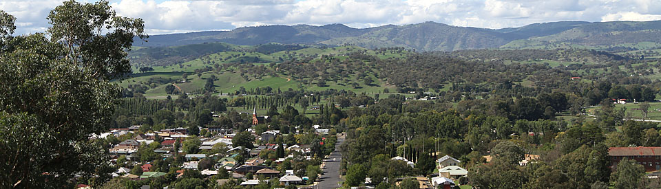
Rotary Lookout and other Views of the Valley
At the top of Wynyard Street (the main street) is the Rotary Lookout which offers excellent views over the entire valley. From here it is easy to locate the distinctive All Saints Anglican Church, the trees that edge the Tumut River and the river flats of Bombowlee. There are excellent views from the hill and if you travel along Godfrey Street you get dramatic and beautiful views across Tumut Plains and up the Goobragandra River. The road through the Brindabellas to Canberra also offers fine views of the valley.
Tumut Museum
Located at 63 Capper Street, the Tumut Museum began in 1975 and was opened in 1979. Its website explains: "The focus of the Museum is on our collection of Miles Franklin memorabilia, Historical Photographic Collection and items of agricultural machinery relating to the Tumut district. We also collect other items of significance to our community." It is open Saturdays and Sundays from 1.00 p.m. to 4.00 p.m., tel: (02) 6947 9899 or check out http://mgnsw.org.au/organisations/tumut-district-historical-society-museum/ for additional details.
Roman Catholic Church of the Immaculate Conception
The Tumut Catholic parish came into existence in 1858 with a congregation of 1,000 spread from Wagga to Cootamundra. In that year Bishop Polding visited Tumut and laid the Foundation Stone for the first church. By the 1870s the first church was too small and so the present Church of the Immaculate Conception, built out of blue trachyte rock at a cost of £3,200, was constructed. It was opened by the Bishop of Goulburn on 24 November, 1878. It stands impressively on the corner of Capper and Carey Streets.
Pioneer Cemetery
For years the town's Pioneer Cemetery, on the road out to Adelong and Batlow, was allowed to decay but recently it has been revitalised. It is now possible to get a rare picture of the early years of settlement in the area. The most notable gravestone is that of Thomas Boyd who travelled with the explorers Hume and Hovell and was probably the first European to settle in the Tumut Valley.
Walks Around Town
In the car park below All Saints Church there is a sign with a map and three detailed walks around town.
River Walk
Distance: 2000 m return
Grade: Easy
Length of Steps: 2400
Average Walking Time: 22 minutes
Begin at Pioneer Park
Bull Paddock Loop
Distance: 3500 m
Grade: Hard
Length of Steps: 4200
Average Walking Time: 40 minutes
Begin at Pioneer Park
Town Loop
Distance: 2300 m
Grade: Medium
Length of Steps: 2760
Average Walking Time: 25 minutes
Begin at corner of Russell and Richmond Streets.
Suitable maps are available at the Visitor Information Centre.
Elm Drive
Another memorable local experience, particularly in autumn and spring, is the remarkable 'Avenue of Elms' leading down to the Tumut racecourse. Given the decimation of European elms by Dutch Elm disease this is a walk that older people from Europe enjoy as a nostalgic reminder of the trees of their childhood.
Tumut Broom Factory
Millet brooms have been handmade at the Tumut Broom Factory since 1946. Located on 30 Adelong Road and open from 9.00 a.m. to 5.00 p.m. Monday to Friday it is possible to see the brooms being made and equally possible to buy one. Check out http://tumutbroomfactory.com or tel: (02) 6947 2804.
Other Attractions in the Area
Tumut Valley Violets
One of the district's more unusual tourist attractions is the African Violet Farm located at 572 Tumut Plains Road in the old Tumut Plains School House (1878). The African Violets, all 750 named varieties, are grown hydroponically. It is reputedly the largest African violet farm in Australia. It offers Devonshire teas and coffee at the Garden Cafe and is open daily from 10.00 a.m. to 4.30 p.m. For more information contact the owners on (02) 6947 2410 or check out http://www.valleyviolets.com.au.
Blowering Dam
To the south of the town, 12 km from the town via the Snowy Mountains Highway, lies Blowering Dam. The dam, the last to be built as part of the Snowy Mountains Scheme, has the second largest storage capacity in the Snowy Mountains. The dam wall is 120 metres high. In 1978 Ken Warby broke the World Water Speed record when he travelled across the dam at 511.11 km/hour.
The Aboriginal Community at Brungle
The Aborigines Protection Act of 1909 led to the establishment of 'reserves' or 'stations' for Aborigines. These reserves were run by white managers who had enormous control over the residents. They inspected houses for cleanliness, controlled the amount of alcohol, and sent children away if they felt the parents were not capable of looking after them. Brungle was one of the first 'reserves' under this plan and the first manager was so hugely disliked that the local community simply departed within months of his arrival. Other Aborigines were brought in from outlying districts but when the offending manager departed the original inhabitants returned. Today it is an active and successful Wiradjuri community.
The Brindabella Road to Canberra
The road across the mountains via Brindabella to Canberra is gloriously scenic and wild. If it has not been raining the road, which has an extended unsealed section, is adequate but, after rain, the clay soil can become difficult and dangerous. The appeal of this lonely journey is that there are remarkable views back across the Tumut Valley and Brindabella was where Miles Franklin lived and wrote My Brilliant Career.
Trout Fishing
Tumut has become a popular destination for fly fishing. The Tumut River and its tributaries, particularly the Goobragandra, have become justifiably famous for the challenges presented by the brown and rainbow trout. The Blowering Dam is well stocked with cod, yellowbelly and trout.
Bushwalking
There are a large number of bushwalking tracks in the area many of which are now part of the 440 km Hume and Hovell Walking Track which runs from Yass to Albury. One of the most interesting is the 18 km Thomas Boyd Trackhead. Information about the tracks, including detailed topographical maps, can be obtained from the Tumut Visitors Centre, tel: (02) 6947 7025.
Festival of the Falling Leaf
It is often argued that autumn in Tumut offers the most spectacular display of 'colours' in New South Wales. In the 1950s the local headmaster, Alf Woods, instituted the idea of a Festival to celebrate the arrival of autumn and the falling leaves which characterised the town's many parks and gardens. It has become a hugely popular event and is held each year in April-May. For more information check out the website: http://www.fallingleaffestival.com.au/ which has dates and other important information.
Black Perry Lookout
About 45 km from Tumut, on the Snowy Mountains Highway between Tumut and Talbingo, there is a turnoff to Black Perry Lookout. This lookout on the edge of the Kosciuszko National Park offers an excellent panorama over the rugged, densely timbered wilderness that is the Snowy Mountains. Check http://www.nationalparks.nsw.gov.au/kosciuszko-national-park/black-perry-lookout/lookout for more information.
Yarrangobilly Caves
Located 76 km south of Tumut on the Snowy Mountains Highway, the Yarrangobilly Caves were formed in a belt of limestone 440 million years ago. There are an estimated 60 caves in the area, of which four - South Glory Cave, North Glory Cave, Jersey and Jillabenan - are open to the public. The great appeal of Yarrangobilly Caves is that this is much more than an cave experience. It is ideal for bushwalking, trout fishing and there is the Thermal Pool where the water, even when there is snow on the ground, is 27°C. And, of course, being in the Snowy Mountains the air seems crisper and cleaner and the night skies are ablaze with stars which seem to shine brighter and sharper. Check out https://www.aussietowns.com.au/town/yarrangobilly-caves-nsw for more detailed information.
History
* Prior to European settlement the Tumut Valley was inhabited by the Wiradjuri First Nations people for thousands of years.
* In 1824 the explorers Hume and Hovell travelling down the Murrumbidgee River, discovered the point where the Tumut River met the Murrumbidgee, and entered the Tumut Valley.
* By 1828 settlers had moved into the valley. Thomas Boyd, an Irishman who had been on Hume and Hovell expedition, settled at 'Rosebank' near Gilmore and a Mr Warby settled at 'Darbalara' near Brungle. On 27 November, 1828 the explorer Charles Sturt stayed at Warby's house.
* Elizabeth Warby, probably the first European to be born in the valley, was born at Darbalara on 10 May, 1830.
* The district was slowly settled by squatters over the next thirty years. By 1856 the town had three pubs, a single school building and a few mud and slab huts.
* The town was surveyed in 1848 but a major flood in 1852 persuaded the settlers to move the town to higher ground.
* By 1860 the town was prospering. There was a local newspaper. The local cricket club was holding annual meetings and when cricket was played on the town's racecourse three publicans' booths were providing refreshments.
* The goldrushes at Adelong and Kiandra saw the town become a conduit for miners heading to the goldfields. Consequently, in 1860, there was a report of 1,200 men passing through the town in four days.
* With gold the town acquired its solitary local bushranger - William Brookman, a carpenter, who joined the 'Blue Cap' gang.
* By 1866 there were eleven pubs in the town and by 1880 this had increased to eighteen.
* In 1877 James Kelly (brother of Ned Kelly) stole some horses in Wagga. He tried to sell in them in Tumut.
* A branch railway line from Gundagai to Tumut was authorised in 1884 but it wasn't completed until 1903.
* Tumut became a municipality in 1887.
* The Tumut Shire, including Batlow and Adelong, was created in 1928.
* By the 1950s the town had become a service centre for Batlow, Adelong, Talbingo and smaller settlements in the surrounding district. There was a Butter Factory, a millet broom factory, a timber industry and the area was noted for sheep and both dairy and beef cattle.
* In 1968 the Blowering Dam was officially opened.
* In 2001 Visy opened their Tumut Pulp and Paper Mill at Gilmore.
* Between 2001 and 2006 it as estimated that Visy was directly and indirectly involved in the employment of 2,800 people in the Tumut Shire.
* In 2009 Visy's Pulp and Paper Mill was expanded with an investment of $450 million.
* Today the town is prosperous largely due to the success of the timber industry. It remains an important service centre and, with the popularity of skiing, fishing and bushwalking, its tourism industry has grown.
^ TOPVisitor Information
Tumut Region Visitor Centre, Old Butter Factory, corner of Gocup and Adelong Roads, tel: (02) 6947 7025.
^ TOPUseful Websites
There is a useful local website - http://www.visittumut.com.au/ - which includes information about accommodation and eating in the town.
^ TOP
The Montreal Theatre – my grandfather J J J Learmont had this theatre designed and built in 1929 and it opened on 2 April 1930. The name Montreal is an anagram of our name (Learmont). The theatre was sold by our family in 1998 and is still running today as the Montreal Community Theatre Inc with a strong group of volunteers. More details can be seen on http://www.nsw.nationaltrust.org.au/montreal.html or a Google search of Montreal Theatre Tumut
Good work Roger, glad someone knows the exact dates! Such a great town to grow up in, the freedom kids enjoyed and the challenging climate made us tough kids!
Tumut Valley Canoe Club meet at 5.00 pm during daylight savings at their clubhouse next to the Tumut Riverglade Caravan park. Contact Adam on 0407 896 074 for details
Our own brewery! Open every weekend and every public holiday (except Christmas Day). Worth mentioning. Check out http://www.trbc.com.au for more information.
Police sen serg of police John Costello wife Mary Costello 1906 to Dec 1917 Tumut police
Also policed Tumbarumba batlow Gundagi yass wagga uranna bowna albury batlow
They helped everyone that need help raised money for schools , hospitals , familys in need ,
War , feed the jails ,
Gave donations to st vincent hospital Sydney and the Convents
Some of the towns people also helped they held dances raffles anything they could to help
Went to Sydney ryted to Rosebay and then looked after soldiors when they come home from war sick nursed them back to health .
Then 1947 passed away god bless there soles
you should put the area Km2
Ta
Are there apple orchards in the Tumut area?
Yes. Batlow, which is close by, is famous for its apples and, if I remember correctly, there is an outlet at Gundagai where they sell Batlow apples.
There are 4 Roads into Tumut the other two include the Snowy Mountains Highway from Adelong or from the other side being Talbingo. In fact you could also include the Wee Jasper Rd which makes five.
There are many great cycling routes around Tumut with fantastic mountain bike tracks and gravel roads. Road cyclists are also treated to a great variety of riding from lovely quiet country roads to hills and the beautiful vistas that go with that.
But, sadly, not a brilliant cycle route from Tumut to Batlow. It could rival the many great cycle routes in New Zealand, Victoria and South Australia. Maybe, just maybe, sense will prevail. It would be such an important tourist asset to the region.
Information on Thomas Boyd my grandfather several generations removed and his home Rosebank
You haven’t mentioned the amazing ruins outside Adelong of the old gold mine. An absolutely fascinating place to visit that anyone in the area interested in history, archeology, engineering or geology would find surprisingly engaging and extensive.
Yes. They are mentioned under Adelong.
Hi guys, i know it might be a long shot but I’ll try. I’m looking for a hunting property in your area, shoot me a message if anyone is interested Thank you, much appreciated.
Are there any relatives of Herbert Boyd Falconer in Tumut. He was my Grandfather.