Popular 100 km-long historic island south of Hobart.
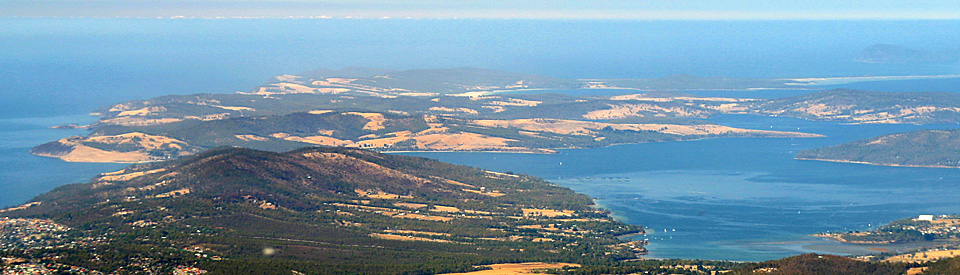
Bruny Island, which is about 50-60 km long, is a popular day trip destination easily accessible from Hobart. In reality it is two islands joined by a narrow isthmus called "The Neck". Interestingly North Bruny Island is quite different from South Bruny Island. The north is characterised by open pastures and light bushland and is known to be drier than the south. The south is heavily timbered, hilly and has sections of rainforest.
The visitor should ensure they visit all parts of the island. The ferry arrives at the north and the road passes south of the tiny townships of Dennes Point and Barnes Bay; the Neck is home to the Truganini Lookout which offers some of the best views on the island; and the southern part of the island includes the townships of Adventure Bay, Alonnah and Lunawanna as well as the impressive Cape Bruny Lighthouse. It is the natural beauty of Bruny Island which is the real attraction. The beaches are impossibly white, the waters (on a clear day) are wonderfully blue, and the road down the island winds from one bay to the next. The island, which has an area of 36,210 ha, has a total of 225 km of road. Today its main industries are farming and tourism.
Location
The ferry across to Bruny Island is located 33 km south of Hobart via the Channel Highway to Kettering where the vehicular ferry to Roberts Point on North Bruny takes 15 minutes, departs ten times a day, and eleven times on Friday. See https://www.sealinkbrunyisland.com.au for details.
^ TOPOrigin of Name
The French explorer, Bruni D'Entrecasteaux is remembered in both the D'Entrecasteaux Channel and Bruny Island. Originally name "Bruni" the spelling was changed to Bruny in 1918. The local Aborigines called the island Lunawanna-alonna which explains why two of the island's small settlements are named Lunawanna and Alonnah.
^ TOPThings to See and Do
(1) North Bruny Island
Cape Queen Elizabeth Walk
At the southern end of the North Island, just before you reach The Neck, the Cape Queen Elizabeth Walk (3 hours return and defined as moderate) heads off the Main Road out to the coast, passes the Bruny Island airstrip, runs between Big Lagoon and Little Lagoon, climbs up Mars Bluff, offers some excellent views across The Neck and then traverses some particularly impressive coastal heathland. There are two possible tracks beyond the Big Lagoon - one heads towards remote Miles Beach, the other heads southward and offers views across Adventure Bay. Check out https://www.brunyisland.com/adventure/hikes-and-walks for more details.
(2) The Neck
The long, narrow isthmus of land known as "The Neck" joins North Bruny to South Bruny. The main attractions are the Neck Game Reserve which has boardwalks and viewing platforms where patient visitors, at dusk, can observe little penguins returning to their burrows after a hard day collecting food out at sea. There is an explanatory interpretation board. This is also a place where you can observe short-tailed shearwaters. A superb 360° view of the north and south sections of the island can be had from the Truganini Lookout.
3) South Bruny Island
Alonnah
Alonnah is one of the main towns on the island. It is located approximately 35 minutes from the ferry and, apart from a Police Station and a School, its main claim to fame is the Hotel Bruny which is, reputedly, the southernmost pub in Australia.
Bruny Island Cruises
Bruny Island Cruises leave from Hobart and collect passengers at Adventure Bay. It is possible to join the cruise at either destination. The website explains the experience as "Spend a full three hours travelling along Bruny Island's rugged Southern Tasmanian coastline to spot the island's abundant sea and coastal wildlife such as seals, dolphins, whales, albatross and other seabirds. Sit at the bottom of Bruny Island's towering sea cliffs, feel the joy of being surrounded by thousands of seals and watching dolphins surf on the bow wave of the boat." The cruise travels down the east coast of Bruny Island from Adventure Bay to The Friars and Tasman Head. It has won literally dozens of awards including Tasmania's Best Tourist Attraction and been voted one of the Greatest 100 Trips of the World. Certainly it is the best way to see the island's dramatic southern coastline. Check out http://www.brunycruises.com.au/ where it is possible to download a brochure which provides details of prices and times.
Memorials on the Island
At Adventure Bay there are memorials to the early explorers including a memorial to Captain Furneaux (opposite the caravan park); a Bicentennial Memorial to Captain Cook (erected in 1977) which is located at the far end of the road around the bay; the site of Cook's Tree where in 1866 the Comte de Beauvoir recorded that the tree had the inscription "Cook, 26 jan 1777". There is a brochure, complete with a map identifying the relevant historic places, available titled simply Adventure Bay. It lists 16 places of interest around the bay.
Bligh Museum of Pacific Exploration
Located at 876 Main Road, Adventure Bay, the Bligh Museum of Pacific Exploration was established in 1954 by the late Dr J. Bruce Hamilton to display historic maps, documents, paintings and other artifacts relating to Tasman (1642), Furneaux (1773), Cook (1777), Bligh (1788, 1792), D'Entrecasteaux (1792, 1793), Flinders (1798) and Baudin (1802) all of whom explored Adventure Bay. The museum is open daily from 10.00 am - 4.00 pm or by arrangement. For more information tel: (03) 6293 1117 or 0407 689 877.
Walks at Adventure Bay
Adventure Bay was used by whalers from the late 1820s until the early 1840s. Today it offers the visitor a number of pleasant and interesting bush and coastal walks.
There are five main walks:
(a) Mavista Nature Walk
Drive along Adventure Bay Road and turn into Lockleys Road and then into Resolution Road. The Mavista Nature Walk is clearly signposted. It is an easy 20-30 minute amble through rainforest and fern glades near Water Fall Creek. There are useful information boards containing details of the island's floral history.
(b) Grass Point
The Grass Point Walk starts at the entrance to the National Park where there is a useful information board. You have to traverse the short beach to start the coastal track to Grass Point. It takes 90 minutes return, is of moderate difficulty, and is suitable for families. It covers flat terrain and traverses dry forest. The archaeological dig of Captain Kelly's whaling station has uncovered a number of structures from that era including his well-constructed stone rubble whaling headquarters. During the spring and autumn it is possible to see southern right whales making their way along the coastline.
(c) Fluted Cape
If you want a challenge, this is for you. The walk is three hours return and is defined as "challenging". It can be started from either the East Cove carpark or Grass Point. It offers fine coastal views, spectacular views of Fluted Cape, opportunities to see White Breasted Sea Eagles and to explore the dry forest coastal flora.
(d) Mount Mangana
The walk, which takes around 90 minutes return and is of moderate difficulty, passes through beautiful rainforest with eucalypts and ferns and offers panoramic views.
(e) Clennett's Top Mill Site
This short 30 minute return and easy walk passes through rainforest from the western side of Coolangatta Road to an old mill site where there are a number of interpretation boards and pieces of ancient machinery.
Labillardiere Peninsula Walks
The Labillardiere State Reserve on South Bruny has been listed by the National Estate. The listing explains: "Labillardiere carries a diverse selection of its vegetation, including structures of open forest, eucalypt woodland, open woodland, scrub/heath associations, shrubland, open shrubland, hummock grassland, herbland and closed herbland. Wildflowers grow in great profusion and giant trees thrive in the forests ... It provides a representation of southern Tasmanian flora and fauna in a largely pristine condition".
There are two main walks at Labillardiere Peninsula
(a) Luggobine Circuit walk
The Luggobine Circuit walk is a moderate, 90 minutes return walk which starts at Jetty Beach and completes a circuit which is a pleasant, short version of the longer and more challenging Labillardiere Peninsula Walk.
(b) Labillardiere Peninsula Walk
The Labillardiere Peninsula Walk is a strenuous seven hours return walk around the peninsula which encompasses heathlands, beaches, dry forests, Mount Bleak, exposed coastline and fine coastal views of Partridge Island which is home to one of the largest populations of the endangered forty-spotted pardalote - a small bird with a very small beak which is only about 10 cm long and weighs between 9-13 grams.
East Cloudy Head Walk
The East Cloudy Head Walk is a demanding 4-hour, 12 km return trek although the first 3 km along the white sands of Cloudy Beach are glorious. It takes in panoramic views along the coast, impressive heathlands and the diversity of birds on East Cloudy Head. Access to the start of the route is via the C644. See https://www.alltrails.com/trail/australia/tasmania/east-cloudy-head-track for more details and a map.
Cape Bruny Lighthouse
Cape Bruny Lighthouse is a serious drive from the ferry taking more than an hour (and then you have to drive back) but the journey is worth the effort. The cape was first recorded by Abel Tasman in 1642. The lighthouse, which is the third oldest Commonwealth light station in Australia, was built in 1838 after three ships had been wrecked in the area in 1835. It was designed by John Lee Archer and built with convict labour. The tower was made from locally quarried stone and the lamp was initially lit by whale oil. It is 19 metres high with an elevation of 105 metres and a range of 26 nautical miles. The lighthouse was replaced in 1996 by an automated solar lightstation on the adjacent headland. The historic lighthouse which is no longer operational was transferred to the Tasmanian Government in 1998 and the reserve around the lighthouse has become part of the new Labillardiere National Park. For more detailed information check out https://www.capebrunylighthouse.com.
History
* Prior to European settlement Bruny Island was inhabited by the Nuenonne First Nation people.
*The first European to visit Bruny Island was Abel Tasman who sailed the Zeehaen and Heenskerck, along the coast in November 1642 and briefly entered Adventure Bay. He was prevented from landing by gale force winds.
* In 1773 Captain Tobias Furneaux and Captain James Cook reached Adventure Bay where they replenished their water and wood supplies. Cook was sailing the HMS Resolution and Furneax the HMS Adventure after whom the bay was named.
* Four years later on 26 January 1777 Cook sailed the HMS Resolution and HMS Discovery into Adventure Bay and stayed for two days. William Bligh was Cook's sailing master. Cook reported that he made amicable contact with the Aborigines on the island.
* In 1788 Captain Bligh arrived in Adventure Bay in the HMS Bounty with a botanist named Nelson. It is known that they planted some seeds, which they had brought from the Cape of Good Hope, at East Cove.
* In 1792 Bligh returned and found that an apple tree had sprung from the seeds. This has led to the claim that Bligh was the true father of the 'Apple Isle'.
* In 1792 the French explorer, Bruni D'Entrecasteaux reached the island. In spite of the earlier visits by British explorers it was D'Entrecasteaux who gave his name to both the island and the channel which separates Bruny Island from the mainland.
* By 1804, when the settlement was established at Hobart Town, whalers and sealers were already on the island. It was common for them to take First Nation women hostage and use them both as sealers and sexual slaves.
* The most tragic story relating to Bruny Island is story of Truganini who, quite inaccurately, became known as "the last Tasmanian Aborigine". Truganini's early life (she was a native of Bruny Island and her father had been an important elder) and her treatment at the hands of the Europeans is emblematic of the treatment of Tasmanian First Nation people. By the time she was seventeen she'd been raped (and probably contracted syphilis), her mother had been stabbed to death, her uncle had been shot, her stepmother had been kidnapped by mutinous convicts who took her to China, her sisters had been enslaved by sealers, and her betrothed had been murdered.
It is the story of the death of the man she was betrothed to which gives an insight into the brutality of this early period of Bruny Island's history. In my book Blood on the Wattle: the Massacre and Maltreatment of Aborigines since 1788, the story is recounted: "Perhaps the most devastating event in Truganini's life occurred shortly after she agreed to marry a man called Paraweena. At the time Truganini was wont to visit the convict camps around Bruny Island. Paraweena, accompanied by a friend, came to call her back from the camp. The convicts protested: they wanted Truganini to stay. Eventually two convicts, Paddy Newell and Watkin Lowe, both of whom had reputations for viciousness, agreed that Truganini could leave. They even offered to row the three Aborigines across the narrow stretch of water to North Bruny Island. Halfway across the channel Newell and Lowe overpowered Paraweena and his friend and threw them overboard. As the two men attempted to clamber back into the boat one of the white men grabbed a hatchet which had been lying in the bottom of the boat and lashed out at Paraweena. He cut his hand off at the wrist. Then he turned and did the same to Paraweena's friend. Newell and Lowe rowed away, leaving the two injured men to drown."
* In 1829 George Augustus Robinson, the self-styled Protector of Aborigines, established an Aboriginal settlement near Great Bay on Bruny Island.
* By the 1830s the island was being used for timber, apple orchards and sheep and cattle grazing.
* In 1838 the Cape Bruny lighthouse was completed.
* In 1918 the spelling of the island was changed from Bruni to Bruny.
* In 1975 the ashes of Truganini were finally scattered in D'Entrecasteaux Channel.
^ TOPVisitor Information
Bruny D'Entrecasteaux Visitor Information Centre, 81 Ferry Road, Kettering, tel: (03) 6267 4494.
^ TOPUseful Websites
Bruny Island Tourism has its own website - http://www.brunyisland.org.au/ - which has useful information about accommodation, eating and ferry times.
^ TOP
No reason is given for the change in 1918 from Bruny to Bruny?