Substantial town on the Gascoyne coast where the river runs upside down.
Carnarvon is a prosperous service town and holiday destination surrounded by banana plantations. It is located between Shark Bay and the Ningaloo Reef. Since the 1930s it has become famed for its produce with the rich flats of the Gascoyne River being used to grow bananas, avocados, coconuts, dates, macadamia nuts, mangoes, pawpaws, pecans, tomatoes, pineapples, melons and various varieties of beans due to the aquifers on the Gascoyne River. Today it supplies 70% of Western Australia's winter vegetable requirements. Carnarvon achieved fame when, on 20 July 1969, Neil Armstrong stepped out of Apollo 11 onto the surface of the moon. His famous words "One small step for man. One giant leap for mankind" were relayed via the tracking station at Carnarvon. Today the town has a range of tourist activities and is an important service centre for the surrounding properties.
Location
Carnarvon is located 895 km north of Perth on the North West Coastal Highway, Carnarvon. Located on the southern bank of the Gascoyne River it lies 3.3 metres above sea level and has an annual average rainfall of only 229 mm.
^ TOPOrigin of Name
Carnarvon was named after Henry Herbert, 4th Earl of Carnarvon, who was the British Secretary of State from 1866-74 and had been the Secretary of State for the Colonies in 1866-67 and 1874-78.
^ TOPThings to See and Do
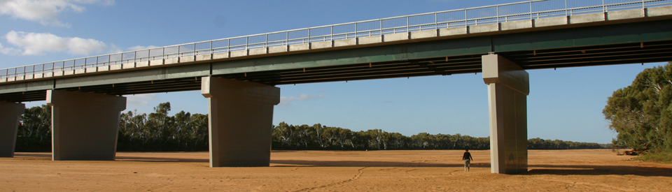
The River That Runs Upside Down
On average the Gascoyne River only flows for 120 days a year ... well, flows above the surface of the riverbed for 120 days a year. It is one of the strangest sights in Australia to drive across the river - it is a broad river and the modern bridge is impressive - look below and see a totally dry riverbed and observe the pipes and pumps on the riverbanks.
The river's water table (known as its aquifers) lie below the sand and it is possible to access them by drilling through the sand until you reach the water. It is equally possible to go for a walk across the dry riverbed. It is firm - people even ride cars and motorbikes on it - and you would never know there is water below.
The reason: Carnarvon is located at the only point on the Australian coastline where the vast desert areas of Western Australia reach out into the Indian Ocean. The result of this strange phenomenon is that the mouth of the Gascoyne River is a 300 km tongue of sand which acts as a huge water storage system.
Perhaps the strangest feature of all is that this is real desert country. Check out the Bureau of Meteorology climate statistics (http://www.bom.gov.au/climate/averages/tables/cw_006011.shtml) and you will find that the area experiences an average rainfall of 227 mm (that is less than 9 inches) per annum and that it only gets an average of 25 days of rainfall (less than a day of rain in November and December) a year. Knowing those harsh statistics, to gaze across the banks of the river and see fertile fields of bananas and tropical fruit is genuinely surreal. Such richness in an area the Western Australian Department of Agriculture has described as 'mulga scrubland'.
It is equally true that this is cyclone territory (more than 16 have hit the town in the past 50 years) and when the cyclones hit the river floods as though it had never been dry and, given the ferocity of the winds, the crops are decimated. The 14 March, 2015 flood and disaster caused by Category 3 Cyclone Olwyn (which hit the town directly) was reported by the ABC at the time with the Shire President, Karl Brandenburg, declaring: "We're critical at the moment with no power and water … You can imagine hospitals, airports, sewerage, even getting the debris off the roads so we can get the emergency crews around … There's tree debris everywhere, there's sheets of iron, roller doors, signs in the street. Huge trees have been uprooted, roller doors have been caved in, roof sheeting is missing everywhere.
"The rain was horizontal, I watched one of my trees disappear in the backyard … I watched poles start to fall over down the street in front of my house and just trees everywhere. All the bananas, I've been told, have pretty much been decimated, and now we're even struggling for water … We're just at the start of a good season with a good river and now the plantations have been absolutely flattened … Not only are the crops all destroyed, the sheds are missing as well, and canopies they have for bird and wind breaks for their crops are all shredded."
History of Banana Growing
In 1928 a local named Jack Buzolic wrote: "At present Carnarvon is a small place with four hotels, six stores (four held by white people and two by Chinamen), three drapery shops and one boarding house, and consists of about six hundred people ... Now the whole of Carnarvon and surrounds make their living by the sheep stations in the district ... My opinion is that, of the tropical fruits bananas would grow to perfection if cultivated properly." He planted banana suckers that year and by 1930 had picked his first saleable crop. Although there had been interest in tropical agriculture since 1922 no one had really bothered until Buzolic decided to develop bananas thus broadening the economic base of the town and turning it into one of the most important banana growing areas in Australia. From that modest beginning Carnarvon now supplies 70% of all fruit and vegetables consumed in Western Australia during the winter months. Its total output is over 30,000 tonnes per annum. Crops are usually good although the area has experienced 16 cyclones, 8 floods and 7 droughts in the last 50 years.
The Main Street - Robinson Street
By the 1880s Carnarvon had become the service centre and port for the Gascoyne's wool industry. Life on the stations was hard and the treatment of the local Aborigines was appalling. Camel teams, driven by Afghan camel drivers, brought the wool from the stations to the port. It was these camel teams that produced Carnarvon's extraordinary main street, Robinson Street, which may well be the widest street in Australia. The novelist Nene Gare has explained the function of the main street: "The wide main streets were made to take a double team of camels pulling twelve-foot-high drays shod with big iron wheels. There had to be room for the Afghan drivers to take a round turn, with the result that modern traffic finds itself with parking space in the middle of the road as well as at both sides."
Carnarvon Earth Tracking Station - the OTC Dish and Carnarvon Space and Technology Museum
Located 10 km south of Carnarvon, the Carnarvon Space Tracking Station was built as a combined Australian-American project with the assistance of NASA. It was completed in 1966 and was used extensively during the various NASA moon projects. The dish weighs 300 tonnes and is 29.6 metres in diameter. It was the base which gave the command for the Trans Lunar Insertion (TLI) which sent the Apollo missions to land on the moon. On 20 July 1969 Neil Armstrong stepped out of Apollo 11 onto the moon and famously said: "One small step for man. One giant leap for mankind". Those words were relayed to the world via the tracking station. Between 1964-1975 the tracking station was vital to the Mercury, Gemini, Skylab and Apollo missions launched by NASA and, at its peak, employed 220 people. It was eventually closed in 1987 after being used to track Halley's comet. Today it is home to the Carnarvon Space and Technology Museum which takes visitors back to a time when the station was a vital part of the space race. It took seven years for the volunteers to collect the memorabilia and equipment which allows visitors a unique opportunity to be part of the tracking station during the 1960s. It was opened in 2014. Today the museum is open seven days a week from 9.00 am - 4.00 pm April to September and from 10.00 am - 2.00 pm October to March. Check out http://www.carnarvonmuseum.org.au/ for more details.
Historic Precinct
The town's Historic Precinct is located just 3 km from the town centre and incorporates One Mile Jetty, the Shearing Hall of Fame, the Carnarvon Tramway and the Lighthouse Keepers Cottage Museum.
One Mile Jetty
The One Mile Jetty stretches 1493 metres into the bay on the western side of Babbage Island. It was built in 1897, added to in 1904 and widened in 1912. Carnarvon was the first port to load live sheep. However it discontinued the operation in 1966 when road transport replaced the ships that plied the coast. It is possible to catch the Coffee Pot Train. Check out http://www.carnarvonheritage.com.au/coffee-pot-train.aspx for details.
Shearing Hall of Fame
A recent attraction in the Historic Precinct is the Shearing Hall of Fame. As the website explains: "The Shearers Hall of Fame showcases the history of shearing in the Gascoyne region. The display highlights the vibrant shearing culture of the area and tells many tales and stories of the local legends over the years. One such famous story tells of the ‘Mad Eight’ who in 1923 at Williambury Station shore almost 18,000 sheep in a fortnight, all with hand shears. When it was found that the Williambury fleeces that year averaged 11lb each, the Mad Eight clinched their place in the Shearing’s Hall of Fame." Check out http://www.carnarvonheritage.com.au/shearers-hall-fame.aspx for more details.
Lighthouse Keepers Cottage Museum
At the landward end, and overlooking the jetty, is the Lighthouse Keepers Cottage Museum. It was built in 1897 and used until the 1970s. It was opened as a museum in 1988 and provides an insight into the daily life of lighthouse keepers.
Gwoonwardu Mia Aboriginal Heritage and Cultural Centre
Opened in 2009 the Aboriginal Heritage and Cultural Centre combines a cafe (which serves bush tucker), an art space, a retail space where artefacts can be purchased, an interactive interpretative exhibition where local people tell their stories (Old People Talking) and a botanical garden and walking trail where the visitor can identify indigenous plants. Check out http://www.waitoc.com/operator-info/gwoonwardu-mia-the-gascoyne-aboriginal-heritage-and-cultural-centre-inc for details. It is open Monday to Friday from 9.00 am - 4.00 pm. Tel: (08) 9941 1989.
Water Activities
Carnarvon prides itself in being a holiday destination with a mild climate and plenty of water activities including boating, swimming, surfing, kite boarding, paddle boarding, windsurfing and canoeing.
Other Attractions in the Area
Blowholes, Quobba Station, Lake Macleod and the Korean Star
North of Carnarvon lie a series of unusual attractions including The Blowholes, Quobba Station, Lake Macleod, the Dampier Salt Mine and what remains of the wreck of the bulk carrier, Korean Star.
The Blowholes
Located 24 km north of the town is a turnoff to 'The Blowholes'. The Blowholes (the plural is relevant - there must be 20 or 30 of them) are just south of the point where the road reaches the coast. This is 75 km from the town. The road crosses some large sand dunes and the traveller is greeted with a huge sign declaring: 'KING WAVES KILL'. This is not a casual warning. Surprise king waves have caught and drowned a number of visitors. The Blowholes were first discovered by Europeans as recently as 1911 and since then they have become a popular tourist attraction. They are reliable with the swell from the Indian Ocean being forced through the rocks. On a good day the spray can reach a height of 20 metres.
Lake McLeod and Dampier Salt Mine
Located 65 km north of Carnarvon, Lake Macleod is a huge 207,200 hectare coastal salt lake which is 110 km long and 40 km wide. The lake is mined by Dampier Salt, a subsidiary of Rio Tinto, who ship the salt out of the area from the jetty at Cape Cuvier. Road trains carry the salt to Cape Cuvier. For a detailed description of the process check out http://www.riotinto.com/ourcommitment/features-2932_5111.aspx.
Quobba Station
Located 83 km north of Carnarvon, Quobba Station is a working station which stretches for 80 km along the coastline north of Carnarvon. It is now a holiday destination for people interested in fishing, surfing, enjoying pristine beaches, whale watching in season, marvelling at the wildflowers in season, and walking along the lonely beaches looking for dolphins, turtles, osprey and sea birds. Check out http://quobba.com.au for details of accommodation and holidays.
Korean Star
On 21 May, 1988 Cyclone Herbie hit the area and the Korean Star which was waiting to be loaded was blown onto the rocks where it subsequently broke into two. The wreck lies at the bottom of the 60 metre cliffs at Cape Cuvier and can be reached by 4WD down a road which cuts between the cliffs. However in the 25 years since it was wrecked the sea has worked its magic and very little of the wreck is left today.
Miaboolya Beach
It is rare to find a nudist "clothes optional" beach in Western Australia but this popular destination, 22 km north of Carnarvon, is the place where the locals go to swim, do some crabbing and, if the mood takes them, do a bit of naked sunbaking.
Bernier and Dorre Islands
Off the coast from Carnarvon are Bernier and Dorre Islands. In recent times the waters around the islands have become famed for their fishing with anglers getting good catches of Pink Snapper, Spangled Emperor, Red Emperor, Coral Trout, Baldachin Groper, Cod, Spanish Mackerel and Cobia.
The islands are now both uninhabited (there is no access to Dore Island and there is only day access to Bernier Island) apart from the very rare banded-hare wallaby, Lesueur's rat kangaroo, little barred-bandicoot and Shark Bay mouse all of which are extinct or nearly extinct on the mainland. The islands are narrow strips of coastal limestone surrounded by cliffs which rise, at their highest point, to about 45 metres. Today it is almost forgotten but both Bernier and Dorre Island played a significant role in the destruction of the Aborigines of the Gascoyne and Pilbara. Some time before 1910 the islands became used as a 'hospital' for mainland Aborigines who had contracted venereal disease. The 'patients' were shipped across to the islands to isolate them and, in turn, they were separated so the men were located on Bernier Island and the women on Dorre.
In her book The Passing of the Aborigines, Daisy Bates recalls: "Dorre and Bernier Islands: there is not, in all my sad sojourn among the last sad people of the primitive Australian race, a memory one half so tragic or so harrowing, or a name that conjures up such a deplorable picture of misery and horror unalleviated, as these two grim and barren islands of the West Australian coast that for a period, mercifully brief, were the tombs of the living dead. When I landed on Bernier Island in November 1910 there were only fifteen men left alive, but I counted thirty eight graves. There were seventy-seven women on Dorre Island, many of them bed-ridden. I dared not count the graves there."
Today the islands are for fishing and, during the months between May and November, it is common to see whales moving through the area.
^ TOPHistory
* Prior to the arrival of Europeans the area was home to people from the Inggarda, Baiyungu, Talanji, Thudgarri and Mulgana Aboriginal language groups,
* In 1610 the Dutch sailor Henderik Brouwer crossed the Indian Ocean from the Cape of Good Hope to Batavia by sailng the Roaring Forties and then turning north before reaching the coast of Western Australia.
* On 26 October, 1616 Dirk Hartog reached Cape Inscription where he placed his famous pewter plate.
* After 1616 the area of the coast which includes Carnarvon became known as Eendrachsland after Dirk Hartog's vessel Eendracht.
* The coast was explored and traversed in the 17th and 18th centuries by Abel Tasman, Willem de Vlamingh, William Dampier, Pelsaert, Phillip Parker King, and the Frenchmen Freycinet, Hamelin and Baudin.
* Early explorers dismissed the coastline because of its unreliability of the rainfall, lack of permanent water supplies, and the harsh desert vegetation.
* Lieutenant George Grey explored the area in 1839. In February 1839 Grey and ten men were landed on Bernier Island with three whale boats. The plan was to explore the coast north of Bernier Island. They quickly established that there was no water on the island and decided to head for the mainland. During the crossing one boat was smashed on rocks and most of the provisions for the expedition were destroyed. The trip to North West Cape was abandoned and the party attempted to return to Perth. At Gantheaume Bay the other boats were wrecked and the men were forced to walk the 500 km back to Perth.
* It was explored by F. T. Gregory in 1858 (an epic journey which covered 2000 miles in 107 days) but his reports were of an inhospitable environment with limited agricultural potential.
* In 1876 the first settlers, Aubrey Brown, John Monger and C.S. Brockman, overlanded 4000 sheep from York. Brown settled on Boolathana station and Brockman established Brickhouse station.
* Carnarvon was gazetted in 1883 and for most of its early life it served as a port and supply depot for the surrounding pastoral industry.
* Carnarvon's first tramway was built in 1884.
* By 1934 the Gascoyne region was supporting 1.4 million head of sheep.
* In 1964 a NASA tracking station was established at Carnarvon. It was the base which gave the command for the Trans Lunar Insertion (TLI) which sent the Apollo missions in to land on the moon.
* On 20 July 1969 Neil Armstrong stepped out of Apollo 11 onto the moon and famously said: "One small step for man. One giant leap for mankind". Those words were relayed to the world via the tracking station.
* The tracking station was closed down in 1974.
* In 1988 Cyclone Herbie caused the Korean Star to run aground on the coast. It has since been slowly destroyed by the sea.
^ TOPVisitor Information
Carnarvon Visitor Centre, Civic Centre, Robinson Street, tel: (08) 9941 1146.
^ TOPUseful Websites
Carnarvon has two good official websites. Check out http://www.carnarvon.org.au and http://www.carnarvon.wa.gov.au. The Carnarvon Holiday Planner can be downloaded at http://www.carnarvon.org.au/wp-content/uploads/2013/05/Carnarvon-Coral-Bay-Holiday-Planner-2015.pdf.
^ TOP
Years ago I visited Carnarvon by road and visited an Aboriginal girls hostel. At the time they had a 20-seater bus and visited the blow holes.
I’m surprised and disappointed that the most important historical people of Carnarvon have been named as 2 footballers. Whilst they became good footballers they contributed little else of great importance to the town when compared to Kingsford Smith who operated an early transport facility and Frank Wise who stood for parliament and became premier of the state. Although credit for growing the first commercial bananas is given to Jack Buzolic, it was Frank Wise who had some banana suckers sent over from Queensland and grew them in Carnarvon on an experimental basis during his period as an agricultural adviser. I can give some interesting stories re the above if required.
Dear Len, We are always interested in local information which enriches the site. Thanks for this information. Anything else you can offer will be greatly appreciated.By the way: I can’t see where we mention any footballers in our history of the town.
Look at Granny Glasgow who delivered over 700 babies. She out stayed 32 doctors and had no holidays for 40 years. Her first husband was a policeman named King. They called him “The King of the West”. I was told he was speared. Granny Glasgow’s maiden name was McGuire her father was a star gent at arms. Her grandson was lost in a flood of the river while taking photos. His father’s name was Jimmy King. There is a centre named the Granny Glasgow Infant Centre. This from her great-grandson and can supply a bit more info if you want.
Your Granny Glasgow sounds absolutely fascinating. I love hidden nuggets of history like this. Thanks for sharing her story. Is there a book about her life ?
I was suprised that the whaling station wasn’t mentioned much, it was a prawn and scallop factory after that, and the prawning boats use to bring in the catch, because my mum worked in the factory and Dad was on the boats at night. we came over from Victoria and stayed at the caravan park near the prawning factory and I went to the High school there.
Years ago I worked driving a grader then scraper based at Lynton Station for pipeline damper to Perth. Good times. I wonder if some of the local community who worked for the shire are still living (Jimmy Michael Denny Belottie or any body else) Love to have chat. They used to call me pommie (ian driving an old white holden pick up) …
With regards to the introduction of the banana industry, although you are correct to say that Jack Buzolic was the first to grow bananas commercially, it was Frank Wise who first introduced the industry by having some banana suckers sent over from Queensland, planted them and established that they could be grown in Carnarvon..
He could be said to be the father of the banana industry in Carnarvon
Mr Wise came over from Queensland as an agricultural advisor and entered WA parliament in 1933 then became premier of the state in 1945
While travelling Australia in a 1996 Ford Falcon towing a 13′ 6″ caravan in 1974, my wife and I parked up at the caravan park and got jobs as deck crew on a prawn boat. We were a couple of young Kiwis on our OE, fresh out of the army and having a ball.
Can’t remember the name of the Prawn Fishery, but they had a sizeable fleet and a large factory operating 24/7. Had a great time and a RAAF guy took us up into the hills and showed us an old WW2 Airfield which he was a sort of caretaker for.
While we were there, a ‘Starlifter’ plane of the American Air force landed, to service the American Military Personal stationed at the Tracking Station. This was the largest freight ‘plane in service at that time.
Your description of the roles of the NASA Tracking Station and the OTC Earth Station are mixed and muddled. The NASA site was located approximately 5km south of the OTC site. Refer to Google Maps for the detail. The museum is located on the old OTC site and this site contains two of the original OTC satellite communications antennas. Commands to the Apollo missions were sent from the NASA site using antennas which were removed when the site closed in 1975. The NASA site was subsequently used by Radio Australia as a replacement for its Darwin site, which was destroyed by Cyclone Tracey on Christmas Day 1974.I worked at the OTC site from 1970 to 1983 and a relative worked at the Radio Australia site.