One of the earliest Victorian goldrush towns
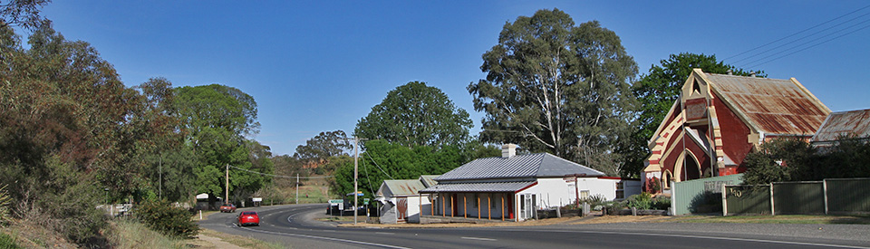
Chewton is a charming and historic gold mining village on the Pyrenees Highway only 6 km south-east of Castlemaine. The very crooked course of the main street reflects the fact that it was based upon a bullock track which wound around a quagmire of muddy claims in a landscape denuded of all vegetation. It is also a comment on the amusing fact that the goldrush town came into existence before the authorities could lay out a neat, grid plan for the settlement. There are many interesting relics of the gold mining days in and around the village which offer an excellent opportunity to understand the hardships and complexities of a gold mining settlement in the 1950s. Chewton itself would prove to be one of the state's richest gold mining localities and one of the most enduring.
Location
Chewton is located 6 km south-east of Castlemaine and 118 km north-west of Melbourne.
^ TOPOrigin of Name
It is probable that Chewton was named after the British army officer, Viscount Chewton. When it was first settled by gold prospectors it was known simply as Forest Creek.
^ TOPThings to See and Do
Exploring Chewton
There is an excellent and detailed guide to the main historic locations in and around the town (check out and download http://chewton.net/wp-content/uploads/2016/11/explore-map.jpg) which lists a total of 36 places of historic interest most of which are located on Main St (the Pyrenees Highway).
Of particular interest are (the numbers relate to the numbers of the downloaded map):
2. Ottery's Butchers Shop
At the height of the goldrush there were 13 butcher's shops in Chewton. Only two remain and this one, at the western end of the Pyrenees Highway dates from the 1860s. It still operates as a butcher's shop and often advertises "Fresh Pet's Meat".
5. Garfield Waterwheel and Mine
Located one kilometre north of Chewton via North Street, is the huge and impressive stone base which once held the Garfield Waterwheel. It was Victoria's largest such wheel (and allegedly the biggest in the world) with a diameter of 22 metres, it carried 222 wrought-iron buckets and it drove a 23 head stamper battery for crushing quartz ore at the Garfield Mine which opened in 1887 and closed in 1911. The Victorian Heritage Database explains: "The wheel was mounted on large stone foundations and was set in motion by a supply of water from a nearby water race. The race had been installed by the State government, as part of the Coliban Water Supply Scheme. The battery and waterwheel were later operated by the Forest Creek Gold Mining Company until about 1903." Check out https://vhd.heritagecouncil.vic.gov.au/places/5254 for more information. There is a signposted 1.2 km walking track which leads to the old Garfield minesite at German Gully.
6. Argus Hill
Located off Walker Street, and listed on the Victorian Heritage Database, the Argus Hill Reef Workings, known locally as Hollow Hill, offer an excellent insight into the scale and scope of gold mining in the area. As recently as 1937 Argus Hill Chewton Gold was floated with 50,000 shares of ten shillings each. They were still working the seam a decade later when they recorded "Further investigation of the reef channel at 260 feet will be undertaken as soon as air and water pipes have been installed."
9. School Teacher's House
Located opposite the Old Wesleyan Church, this simple stone dwelling was built in the late 1850s and was used by the local school teacher, Charles Hardy until 1895.
11. The Monster Meeting Site
Located off Golden Point Road, near the car park, is the site of the shepherd's hut where the Monster Meeting took place on 15 December, 1851.
Here’s the full story as told on the excellent Monster Meeting website - this is taken from a downloadable brochure (https://www.monstermeeting.net/wp-content/uploads/2019/07/MMDLFlyerWeb.pdf): “In late 1851 thousands abandoned their jobs and homes in cities, towns and stations to rush to Forest Creek on the Mt Alexander goldfield. It was the richest shallow alluvial goldfield ever discovered.
“Governor La Trobe tried to stop the gold rush because he feared it would overturn the established social order. He introduced a gold miner’s licence for 30 shillings per month to deter gold diggers. It was a lot of money to pay whether you found gold or not. But it still didn’t slow the gold rush. So he announced that the licence would double to 60 shillings per month. This caused immediate protests across the goldfields.
“In Forest Creek notices urged Fellow Diggers to meet and agitate for justice and 3,000 gathered to protest and determine what they should do. They asked local Gold Commissioner Powlett to convene a general meeting of all miners to consider the proposed increase but he declined. Instead he rode to Melbourne to warn La Trobe of a potentially large and hostile gathering to oppose the increase. So the diggers convened the meeting themselves.
“In the late afternoon of Monday 15 December 1851, with their new flag flying, 15,000 diggers gathered peacefully and announced that they would not pay. And their protest worked. La Trobe, fearing insurrection after being warned of the great meeting, revoked the proposed increase.
“United in their refusal to pay, the diggers became the ‘Diggers’, a political force of men who understood that their strength lay in unity. And this became a connecting thread through the protests of the next three years.
“The Diggers’ triumph did not end conflict about the licence, but it had a major impact on subsequent events.
“The Monster Meeting was Australia’s first organised mass protest meeting. It began a pattern of popular protest orchestrated by leaders who made the link between the ambitions of those ordinary miners and the broader political context of the times.
"In response La Trobe tried to increase government control of the goldfields with a stronger military presence, but to no avail.
"The Diggers’ demands for an end to the licence system grew and spread. Organised protests over the next three years saw the end of the licence system and the first steps to democracy with the introduction of some voting rights, more access to land and the end of the old order on the goldfields."
18. Mount Alexander Hotel
Located on the hill to the east of the Old Wesleyan Church, is the old Mount Alexander Hotel (c.1854) is now a private residence. The sandstone building was once part of the hotel which, before it burnt down in 1863, was recognised as the grandest hotel on the goldfields. There is an old hut at the back which was probably a shepherd's hut which pre-dated the discovery of gold.
19. Old Wesleyan (now Uniting) Church
Located next to the Mount Alexander Hotel, and dating from 1861, the Old Wesleyan Church has, at various times, been both the local Methodist and Uniting Church. It is now the Chewton Community and Senior Citizens Centre. The tiny 1860s shop (no.20) next door has been a baker, a bootmaker and a stationery store.
21. Red Hill Hotel
The charming Red Hill Hotel, characterised by vines which grow out the front, dates from around 1854 and retains an outbuilding which was used as a music and entertainment hall. It is listed on the Victorian Heritage Database. Check https://vhd.heritagecouncil.vic.gov.au/places/69120. The Francis Ormand Mine was once located on the other side of the road.
23. Mine Manager's House
Located next door to the Red Hill Hotel, this was the Mine Manager's house. It was built around 1862 and operated as both the private home and office of the manager of the Francis Ormond Mine.
24. Post Office
The attractive post office with its arches and polychrome brickwork dates from around 1877. The Victorian Heritage Database Statement of Significance notes: "The Chewton Post Office is an essentially intact and fine example of a small post office, with arcade and round arches, designed by the Public Works Department in the period 1870-1885. It was constructed following the appointment of the former Chewton mayor and councillor, JB Patterson, to the Commissioner of Public Works in 1879. Patterson had previously said that he would like to provide Chewton with a "nice little public building. The Post Office is an example of the work of Public Works Department architect, George Watson, whose other work includes the design of the Bendigo Post Office." Check https://vhd.heritagecouncil.vic.gov.au/places/4640 for more information.
The Post Office has a fascinating history which is recorded by the Chewton Domain Society: "At Federation in 1901, the building became part of the Postmaster-General’s Department, which in 1922 planned to discontinue services from the building. To prevent that closure, it was purchased from the Department by citizens of Chewton, and it’s ownership vested in local Trustees. Postal services were run by an independent business operator, licensed by the postal authority.
This system continues to the present day. The register notes it as “an extraordinary example of the importance of local enterprise in ensuring the continued provision of postal services on the premises”. The services do not include house-delivery, so the people of Chewton visit the building daily to collect and send their mail as well as using the numerous services offered at the Post Office.
These daily visits to the Post Office made it the town’s chief meeting place and local message exchange. In this way, not only is the building preserved but also its historic role as the centre point of community life and cohesion. The local Shire of Metcalfe took over the responsibilities of ownership in 1951, but the Trustees continued to manage the building until 1984 when the Shire accepted that responsibility also. Custodianship by local government ended in 1997 when ownership was transferred to the CDS." Check https://chewton.net/history for more information.
25. Town Hall
The Town Hall (1858) at 145 Main Street now houses a couple of thousand photographs - The People and Places Display - relating to the town's past. They are contained in some 25 albums which are organised thematically. The exhibit is open from 1.00 pm - 4.00 pm on Sundays. The simple building was constructed as a Community Hall and served as the meeting room for the Chewton Borough Council from 1861 to 1916. It was once used as a courthouse and retains some structural features relating to that function. For more detailed information check the Victorian Heritage Database at https://vhd.heritagecouncil.vic.gov.au/places/2697. Recent developments are recorded by the Chewton Domain Society: "After 1916, when the historic Borough of Chewton was absorbed by the Shire of Metcalfe, the building continued to be used for community purposes, a tradition which is still unbroken. It is used regularly for community activities: book launch, jazz festival venue, pop-up shop, fashion parade, exhibitions etc. Threatened with demolition at least once in modern times, its preservation is due to local volunteer effort and government assistance over many years. A major renovation program started in 2011 saw the hall closed until 2013 with extensive internal and external works on the structure happening in that time. In 2014 the Mount Alexander Heritage Award prize for Contractors for Specialist Heritage Trade Skills was awarded to the restorers of the Town Hall and in 2016 the CDS received the award for the Restoration of a Heritage Place." For more information check out https://chewton.net/history.
26. Portable Police Lock-Up (c1860s)
Located next to the town hall is the unusual portable police lock-up. An historic relic of the gold days this gaol is made of 5-cm thick oregon slabs which were bolted together. The sign explains: "It consists of a frame of iron rods passing through the heavy wooden planks of the walls, floor and ceiling. If a prisoner managed to break through the wood, he would find he was still imprisoned in an iron cage. These lock-ups could be dismantled and the four wall units, the floor, ceiling and roof loaded onto a police dray to be transported and quickly re-assembled where needed." It was probably made in the 1860s and was formerly behind the town hall on the police paddock. The lockup was saved, restored and reconstructed in 1994-1995 by members of the local community.
33. Trewartha Terrace
Located on Main Street next to the Primitive Methodist Church, Trewartha Terrace, dating from 1859, is an unusual building noted for its zinc coated iron roof tiles which were imported from England. They predate corrugated iron. Similar tiles were used on the roof of the Theatre Royal in Castlemaine. The sign outside notes: "Captain James Trewartha was on the Mount Alexander goldfields at least as early as 1852. In 1858 he built a hay and grain store on the present site. However in January of the next year he had decided to sell his Forest Creek property to enter into a large mining venture. By 1859 Trewartha had mortgaged this property and it may be at this time that the hay and grain store was replaced with the present terrace of two houses."
34. Primitive Methodist Church
Located at 140 Main Road, the Primitive Methodist Church was built in 1860. The Victorian Heritage Database notes that it was "designed by Crouch and Wilson and an unusually early use of the Gothic style by the Primitive Methodists. The most distinctive element of the design is the pair of flying buttresses projecting at angles from the facade." Check https://vhd.heritagecouncil.vic.gov.au/places/69241 for more details.
Other Attractions in the Area
Pennyweight Flat Cemetery
Located 2 km west of Chewton along the Pyrenees Highway and established in 1851, Pennyweight Flat Children's Cemetery was one of the first cemeteries on the Forest Creek Goldfields. Despite its name it was a general cemetery. Watch for the Albion Hotel and 200 metres beyond the hotel turn right into Dick Street, then left into Farran Street and right into Colles Road which leads across Zeal Bridge. The cemetery is 500 metres along this road. 200 people were buried here from 1852-1857 - many had died from typhoid and diphtheria and many of them children.
Eureka Reef
Located 3 km from the Pyrenees Highway on Eureka Street, the Eureka Reef mine area includes a 1.8 km walk which includes the remains of some of the earliest quartz mining relics in Victoria, the foundations of a very early crushing battery, the ruins of a mining village and a chasm which was once an exposed quartz reef.
Expedition Pass Reservoir
Expedition Pass Reservoir is located about 3 km north-east of town, adjacent to Golden Point Road. The reservoir was built in 1868 specifically to supply water for the mines. In recent times it has become a popular for swimming, fishing and picnicking.
Spring Gully
Spring Gully is located south of the town and west of Fryers Road. It is a pleasant location in a gully that was once heavily mined. There is a 1.5 km walk which includes the Spring Gully Junction Mine. The road to Spring Gully passes the Wattle Gully Mine and the solitary grave of Elizabeth Escott and her 16 year old daughter, Fanny.
Elizabeth Escott's Grave
Fryers Road heads south from Chewton to Vaughan Springs and about 1.5 km along the road the Alanmore Track heads left. A short distance along the track is a grave surrounded by a wrought-iron fence. This is the grave of Mrs Elizabeth Escott who emigrated from England, with her eight children, when her husband died. Her eldest daughter, Fanny, is buried beside her.
Site of First Gold Discovery
Located 7 km north of Chewton on the Midland Highway is a turnoff onto Specimen Gully Road and, along the road, about 2 km from the Midland Highway, on the left-hand side, are the remnants of an old stone cottage which was occupied by a shepherd working on the original sheep station which was owned by Dr Barker. A plaque indicates that the shepherd in question discovered gold nearby, which resulted in the local goldrush. There is a plaque on the cairn which reads: "The first gold from the Mount Alexander Goldfield was discovered in this gully by Christopher John Peters on 20th July 1851. Associated with him were John Worley, Robert Keen and George Robinson."
Fryerstown
Located 8 km south of Chewton, Fryerstown is a small village. At its peak during the goldrush it reputedly had 15,000 miners, 25 hotels, 3 schools, 5 breweries and 37 quartz reefs. By 1888 the numbers were down to 542 residents and 2000 within a radius of 3.2 km, including 334 Chinese diggers. At that time there were four hotels and three state schools. It now has a population of a little over 200.
Vaughan and Irishtown
Beyond Fryerstown (it is 12 km from Chewtown to Vaughan) lie the old mining settlements of Irishtown and Vaughan. There were and estimated 13,000 prospectors in the area during the goldrush, including large communities of Chinese miners. With the end of the alluvial gold the numbers quickly dwindled (by 1887 the population was down to 200). Sluicing and dredging were carried out in later years. Bald Hill was at the junction of two very rich gold leads which were extensively mined and sluiced into the 1950s. The Vaughan Mineral Springs Reserve (100 ha) is one of 14 mineral springs discovered by goldminers in 1852. The reserve was declared in 1878. It contains a swimming hole, mining relics, walking tracks along the banks of the Loddon River, native forest, an historic rotunda, and a camping ground. Just outside the reserve, at the top of the hill, is an 1850s burial ground known as the Chinese Cemetery.
Dry Diggings Track
The Dry Diggings Track is a 55 km walking and cycling route which winds its way through the old goldfields countryside which lies between Castlemaine and Daylesford. It passes through Chewton, Fryerstown, Vaughan, Mount Franklin and Hepburn Springs. There is an excellent, detailed Goldfields Track website which explains that "the Castlemaine Diggings National Heritage Park was created in 2002 in recognition of the region’s intimate association with the Victorian gold rush era. From the wet temperate forests on top of the Divide to the dry northern plains, it’s a roller coaster journey for most of the way and not recommended for the inexperienced walker or novice rider. At its outset, the walking track contours on steep slopes above Sailors Creek, hidden away in forest from the mineral spa towns of Daylesford and Hepburn Springs. The bike route goes through town before rejoining the shared use track at Golden Springs. Soon after, your arrival at the spectacular erosion columns of Beehive Gully acts as a fitting introduction to the typical narrow, high-walled gullies pockmarked with mine shafts and riddled with stone ruins, encountered throughout this track. What you are traversing in places like Browns, Sebastopol and Sailors gullies is an open air museum consisting of a century and a half of old mining artefacts – a ghostly, abandoned landscape fading back into bush." For more detailed information and a map check out http://goldfieldstrack.com.au/Pages/Explore/Dry_Diggings_Track.aspx.
History
* Prior to the arrival of Europeans the area was home to the the Dja Dja Wurrung people who were one of five language groups making up the Kulin nation.
* The first European in the area was Major Mitchell on his journey into 'Australia Felix' in 1836-37.
* The first European settler in the region was a Dr Barker whose sheep station, established in the late 1830s, incorporated the present townsite.
* A shepherd named John Worley found gold on Dr Barker's property in 1851 while panning in Forest Creek.
* It has been claimed that 30,000 prospectors arrived in the area within three months in 1851.
* The shallow alluvial goldfield, known as Forest Creek and the Mount Alexander diggings, drew prospectors from Melbourne.
* In December, 1851, 15,000 diggers held a "monster meeting" to discuss grievances relating to a planned increase in the price of the gold licence.
* Chewton was surveyed in 1854. The Red Hill Hotel was opened that year.
* Land sales commenced in 1855. The first buildings constructed included stores, churches and pubs. A school was opened that year.
* A Congregational Church was built in 1856.
* An Episcopal Church and a Wesleyan Church were opened in 1857.
* The town hall was completed in 1860.
* The railway reached Chewton in 1861. A census that year recorded 3353 residents.
* By the end of the 1860s the mining was carried out by a small number of companies sinking shafts in pursuit of gold-bearing quartz reefs.They ran their stamper batteries 24 hours a day.
* Sluicing and dredging for gold were aided when Expedition Pass Reservoir provided a reliable water source in the 1870s.
* The Wattle Gully Gold Mine opened in 1876.
* A government school was opened in 1877.
* A Post Office was opened in 1879.
* By the late 19th century there were three major mines in the immediate vicinity: the Garfield Mine on the north side of town, the Francis Ormand Mine opposite the Red Hill Hotel and the Wattle Gully Mine just south of town.
* On New Year's Eve, 1889 the Francis Ormand Mine filled with water in a flash flood and two men were killed. The mine owners wanted to seal the mine and leave it but the miners insisted the 360 m shaft be pumped out and the bodies recovered for proper interment.
* By 1891 the population had dropped to 1212.
* By 1933 the population of the town was 454.
* In 1974 six children and their teacher were kidnapped from Faraday School and a $1,000,000 ransom was demanded. However, the captives escaped and the kidnappers were caught.
^ TOPVisitor Information
The nearest Visitor Centre is the Castlemaine Visitor Information Centre, 44 Mostyn Street, Castlemaine, tel: (03) 5471 1795. Open 9.00 am - 5.00 pm seven days a week.
^ TOPUseful Websites
There is a useful and detailed local website. Check out https://chewton.net.
^ TOP