Substantial country town in rich agricultural and wine growing region with deep, emotional connections with Japan.
Over the past three decades some country towns have grown and prospered, others have declined both in importance and population. Cowra has grown. Located on the Lachlan River it has become the commercial and administrative centre of a shire where livestock, wool scouring, vegetable growing and processing, vineyards and tourism are the main drivers of the local economy.
Cowra would just be another prosperous rural service town surrounded by vineyards, grazing, rich farmlands and boasting quality restaurants, galleries and craft shops if it hadn't been for its role as a prisoner of war camp during World War II. The public identity of the town has been changed and enriched by the Cowra breakout of 1944 (in which 378 Japanese prisoners of war attempted to escape from a local camp) and the subsequent developing and deep associations with Japan. This dramatic trauma in the history of the district has led the town to focus on and promote the values of pacifism and internationalism. The Japanese Garden, the Japanese cemetery, the Sakura Walk at cherry blossom time, the remnants of the POW camp and the World Peace Bell are all reminders of the town's importance both during the war and after the war as a benchmark of healing and reconciliation.
Location
Cowra is located 310m above sea-level and 305 km west of Sydney via Katoomba and Bathurst. It sits at the junction of the Mid Western and Olympic Highways.
^ TOPOrigin of Name
In the early days of European settlement the crossing point on the Lachlan River was known as 'Coura Rocks'. There is some evidence that a cattle station was established by a Reverend Fulton which was also known as Coura Rocks. It is believed Cowra, probably coming from a Wiradjuri word "Ngoura", is a word used to describe the local area. Certainly the New Wiradjuri Dictionary explains that "ngurang" means home, camp, place or country.
^ TOPThings to See and Do
Exploring the Connections between Cowra and Japan
There is a natural sequence to experiencing all of Cowra's Japanese sites. Follow the route and you will end up being moved by the bravery of the Japanese prisoners of war and the essential decency of the country people who, both in 1944 and still today, were capable of reaching beyond racism and hatred and seeing the humanity and cultural differences which defined Japan.
(1) The Hologram at the POW Theatre
At the Cowra Visitor Information Centre there is a small theatre where, over a period of 9 minutes, the story of the POW outbreak is told by the hologram of a small girl, a resident of Cowra, who describes the events of 5 August, 1944 when 378 Japanese POWs escaped from the camp over the hill from the town. It is an essential part of the story and will place all the subsequent places you visit into the larger context of the camp and the breakout. It has been described by travel writer, Bill Bryson, as "the most enchanting thing I have ever seen".
(2) The Story of the Cowra POW Camp and the Cowra Breakout
In 1940 an army training camp was established at Cowra. Over the next few years over 70,000 military personnel were trained at the establishment. In 1941 a prisoner-of-war (POW) camp was built on the north-eastern outskirts of town.
By 1944 the camp contained about 4,000 prisoners - mostly Italians, Germans and Japanese - who were held in four separate compounds. Each compound was 6.87 ha and there was a pathway, known as the Broadway, which was 700 metres long and 45 metres wide, which divided Camps B and C from Camps A and D. Camp B held 1,104 Japanese POWs. It was seriously overcrowded.
On 5 August, 1944, this camp became the site of the largest mass POW escape in British military history. It was also the only such escape in Australia.
It is important to understand the context of the mass escape. The camp also held Italian prisoners who were, by and large, happy and cheerful. For them the war was over. The Japanese POWs, by contrast, were surly, difficult and resentful. Attempts at employing them outside the camp proved a failure due to their aggressive behaviour. Their lack of co-operation was the product of a culture which imbued in them an overwhelming sense of shame. The Japanese code of honour viewed capture as a disgrace for the individuals involved, their families and their country. Japanese soldiers were expected to commit suicide rather than be humiliated by the subservience implicit in imprisonment. Most of the prisoners had been captured when they were too weak to offer resistance or they were merchant seamen who had been saved when their ships had sunk. They gave false names as they felt news of their capture would shame their families. The Japanese authorities reported all those missing in action as dead. When informed of the deaths during the breakout, the Japanese authorities insisted that those killed must have been Japanese civilians because, in their minds, there was no such person as a Japanese POW. When the prisoners eventually returned to Japan they felt their 'shame' should make them unworthy of return to Japanese society. Half never told their families they had been POWs. It is against this background that the breakout has to be understood.
As early as 3 June, 1944 a Korean prisoner had reported hearing about a plan among the Japanese to attack the camp's garrison, seize arms and ammunition and escape. The report was taken seriously and security was increased.
At 1.30 a.m. of 5 August a Japanese soldier blew a bugle and the prisoners in Camp B opened their hut doors. Screaming loudly and armed with knives, chisels, forks, saws, axe handles and baseball bats the prisoners rushed the wire separating them from Broadway while two other groups headed for the perimeter wire on the other side of the camp. They threw blankets over the barbed wire, or crawled under it, while others dressed in heavy clothing, threw themselves onto the wire so others could climb over. Twenty buildings were burned down in the melee.
Two Australian soldiers who had manned one of the Vickers machine guns were overrun and murdered. Remarkably one of the soldiers, Private Hardy, managed to sabotage his gun before he was killed. Another private was stabbed to death and a lieutenant was killed during the round-up the following morning. Another four Australian personnel were wounded.
In total 378 Japanese POWs escaped. The townsfolk and the media were given partial, and at times false, information.
Within nine days 334 escapees were recaptured. One POW reached Eugowra, 50 km away. Others were killed and some committed suicide - two by putting their heads on railroad tracks. In all 231 Japanese died and 108 were wounded - three dying subsequently of their wounds. The organisers of the break-out had ordered that civilians were to remain unharmed and this proved to be the case.
There are stories of great humanity. One woman named Mrs Weir refused to hand over two escapees until she had given them tea and scones as they had not eaten for days. The men returned to the Weir farm in the 1980s to thank the family.
A student exchange program was established in 1970 between Cowra High School and the Seikei High School in Kichijyouji in Tokyo.
(3) The Japanese Garden and Cultural Centre
The superb Japanese Garden and Cultural Centre (the true highlight of any visit to Cowra) was established with the aid of the Japanese government in 1978-79 to honour both Australian and Japanese dead.
A symbol of the historical ties between Cowra and Japan, it was erected on a 5 ha site and funded by the Australian and Japanese governments and by private donations. It is now maintained on a non-profit basis by tourism.
The garden was designed by Ken Nakajima, a world-renowned figure in traditional Japanese landscape gardening, who worked with the School of Environmental Design from Canberra College of Advanced Education.
After completing the garden Mr Nakajima wrote: "The Japanese treasure nature and try to live with it. My Cowra garden takes this principle into consideration as a 'motto' and treasures all existing objects. In this respect, you will note that all gum trees and rocks on the site have been utilised in their original state."
The garden was designed to reflect the total Japanese landscape. The mountain represents all Japanese mountains. A stream flows down the mountain through a waterfall to a lagoon (representing the mountain ponds) and on to a larger koi-filled lake which equates with the ocean. Japan's cities are represented by the buildings, trimmed hedges suggest rolling hills and each gravel path offers new perspectives to convey the variety of views when meandering through the Japanese landscape. The garden was also designed to blend in with the indigenous environs. Consequently gum trees surround the garden.
A traditional tea house sits on an island. There are wooden footbridges, a wisteria pergola, a bonsho (calling bell), a temple lantern, manicured shrubs and lawns and a delicate and symbolic arrangement of rocks. The 113 species of flora includes water lilies, cherry trees, wisteria, chrysanthemums, magnolia and Australian natives and there are over 120 bird species in the garden. The overall effect is one of serenity and harmony.
Traditional Japanese design has been employed in the construction of the Cultural Centre which houses a display of Japanese art including the Somenishiki Ornamental Vase, 500 hand-carved Japanese dolls, Nanga paintings and a fossilised chrysanthemum estimated to be over 70 million years old.
Within the complex is the Bonsai House (with Bonsai display), a pottery house, a gift shop, a nursery, and the Chabana Restaurant which fuses Japanese and Australian elements and furnishes views over the garden. In the car park is a Japanese rock sculpture which symbolises peace.
In early October, when the cherry blossoms bloom, the centre becomes the focus of Sakura Matsuri, the Cherry Blossom Festival during which there are demonstrations of Japanese arts and crafts, recitals on the shakuhachi flute, tea ceremonies, martial arts demonstrations, kite flying and Japanese food. The complex is open from 8.30 am to 5.00 pm daily, tel: (02) 6341 2233. Check out http://www.cowragarden.com.au/ for prices and more details. There are audio guides available
(4) Sakura Avenue
Sakura Avenue is the road that runs below the Japanese Gardens and connects with the POW Campsite. In spring it is a true wonderland of blossoms as the Avenue of Cherry Trees bursts into bloom. It is one of the highlights of the town during spring.
(5) The POW Campsite
Sakura Avenue heads to the Guard Tower and the remnants of the POW camp. At the corner of Sakura Avenue and Farm Road is a memorial cairn and a monument to the many Italian POWs in the camp who took no part in the breakout. There is little left of the campsite. A few floors and some remnants of buildings. There is good, comprehensive and detailed signage which allows the visitor to imagine what the camp must have been like. Look particularly at the large sign below the guard tower.
From the memorial cairn there is a walking track that takes in the remains of the campsite. The land on the western side of Sakura Avenue contains a large concrete slab by the roadside which marks the site of the camp gaol. There is also an old stone military building which predates the camp and which was used as a storage shed and to the south of the slab are the remains of the camp headquarters. To the south-west is the site of four water storage tanks. The Australian Military Forces quarters were located on the other side of Sakura Avenue. A map and pamphlet are available at the visitors' centre.
The Cemeteries
Remarkably the Japanese War Cemetery in Cowra is the only official Japanese war cemetery in the world. The Japanese POWs who were killed during the breakout were originally placed in mass graves. Until 1964 the care of these sites was left to the local RSL who respected the dead soldiers regardless of their country. In 1964, impressed by this care and concern, the Japanese embassy and the local council jointly decided to create a war cemetery into which the remains of all Japanese POWs who died in Australia were transferred. It was funded by the Japanese government. It contains 522 graves, including Japanese nationals who died during the attack on Darwin, and Japanese civilians who died in internment camps.
In the town's general cemetery are the tombs of the four Australian personnel killed during the breakout and a monument associated with the graves of Indonesian detainees who died of natural causes in the camp. The cemeteries, which are beside each other, are in Doncaster Drive. Use a town map from the Visitor Centre.
Australia's World Peace Bell
While it is not directly connected with the Cowra Breakout, the World Peace Bell, a replica of the original which hangs in the United Nations Building in New York, was given to Cowra because of the enduring local efforts to foster peace and international understanding. It is located in Civic Square, Darling Street (just off Kendal Street - the main street).
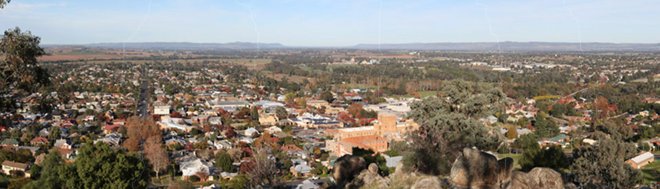
Bellevue Hill Lookout and Fauna Reserve
On Scenic Drive above the Japanese Gardens is the Bellevue Lookout which offers panoramic views over the Lachlan Valley and the town. The photo at the top of this page was taken from the lookout and is a collection of seven separate photos which have been stitched together.
Cowra Heritage Walk
A brochure listing 15 places of historic interest in the centre of town can be downloaded at http://www.cowratourism.com.au/uploads/File/Heritage_Walk_Brochure.pdf. The highlights of the walk include (3) the Australian Hotel on Redfern Street which was the town's first hotel - it was erected in 1846 although it has been completely transformed over the years from the crude bark building that it once was; (6) the Old Stone Flour Mill which was built in 1860 by Patrick and Thomas Walsh. When it opened in 1861 it was the setting for a huge, local ball; (9) Ilfracombe, which was built as a private residence for Nicholas Challacombe in 1879 and served as a surgery for local doctors for over a century; (10) the Cowra Courthouse, a Federation-style brick building with unusual gable ends built in 1879; (13) the first Protestant church on the Lachlan River - the original St Peter's Presbyterian Church, built of brick in 1860, which is situated behind the present church which dates from 1913; and (15) Garden & Montgomerie Solicitors on the northern side of Kendal Street which dates from 1875. It is an easy walk around town with all the historic buildings being bounded by four blocks between Lachlan and Fitzroy Streets and two blocks between Vaux and Liverpool Streets.
Cowra Rose Garden
Directly outside the Visitor Information Centre is the Cowra Rose Garden which contains 880 bushes and 130 varieties including the Cowra Rose. Alex Wood from Swane's Nursery designed the garden and 1,000 Swane's roses were planted in June 1988. A major restoration occurred in 2001 with the planting of 550 new roses. A pamphlet on the rose garden with a plan of the beds and varieties is available from the Visitors Centre.
Aboriginal Murals
A unique use for the cement pylons on the bridge across the Lachlan River has been the painting of local Wiradjuri murals. Access is via a road which, when the river is not in flood, traverses the valley below the bridge. It is easily accessible from the Visitor Information Centre.
The Lachlan Valley Railway Society
The Lachlan Valley Railway Society was set up to restore and maintain steam locomotives and rolling stock. The depot/museum is located in Campbell St, tel: (02) 6342 4999 or check out the website at http://www.lvr.com.au/.
Other Attractions in the Area
Darbys Falls Observatory
Darbys Falls Observatory is open Friday, Saturday and Sunday nights from 7.00 pm to 10.00 pm in winter and from 8.30 pm to 11.00 pm in summer, tel: (02) 6345 1900. For more information check out http://www.cowratourism.com.au/Experience_Cowra/Nature___the_Great_Outdoors/Darbys_Falls_Observatory/ which points out that visitors can expect to see the moon, planets, galaxies, Saturn, Jupiter and star clusters through one of the largest privately owned telescopes in the country and, as a bonus, in one of the darkest places in New South Wales.
Croote Cottage
Located 40 km from Cowra and just beyond Gooloogong, Croote Cottage can be accessed by heading out on the Kangarooby Road (it runs beside the pub and past the General Store) and follow the signs to Croote Cottage. It is well protected by surveillance cameras and has to opened for inspection by the owners. Ask at the General Store or Hotel for times of opening or contact the Cowra or Forbes Visitor Information Centres.
Croote Cottage was built by convicts around 1827 and, as such, is one of the oldest buildings west of the Blue Mountains. It is one of the most important historic pioneer homesteads on the Central Western Slopes having been built of pise bricks and constructed with holes in the walls so the residents could protect themselves against bushrangers and local Aborigines. The original building had shutters and a shingle roof. The walls were 20 cm thick and there was a cellar with a trapdoor where, in case of attack, the women and children could be hidden. Today the cottage has authentic period furnishings
In 1837 John Dowd and his wife moved into the cottage and it is still owned by his descendants. In the early years it had a particularly colourful history. It is believed that during John Dowd's ownership it was visited by the bushranger Ben Hall and Hall, finding Dowd ill in bed, offered to send for a doctor. Apparently Dowd, according to the legend, refused the money and delivered a lecture to Hall about his need to mend his wicked ways. The bushranger allegedly replied: "Too late now old chap" and rode off.
On another occasion Bishop John Polding, the first Catholic Bishop in Australia, stayed at the cottage and said mass for the local Catholic community.
Wyangala Waters State Park
Located 43 km south-east of Cowra along Darbys Falls Road is Wyangala Waters State Recreation Area which covers over 2,000 ha making it the third-largest state recreation area in NSW. The lake has a storage capacity of over one million megalitres and a surface area 2.5 times that of Sydney Harbour. It is surrounded by timbered slopes with granite outcrops. The dam wall is 1.5 km in length.
There are walking trails through the surrounding bushland and a wide range of water sports are possible on the lake. The dam is also known for its trout fishing (brown and rainbow) and its catfish, Murray cod, bream, yellowbelly and silver perch. The office is open from 9.00 am to 5.00 pm daily, tel: (02) 6345 0877. For more details check out http://www.wyangalawaters.com.au/ which provides detailed information about accommodation and activities.
Conimbla National Park
Conimbla National Park represents a rare surviving example of the Central Western Slopes' natural vegetation. It consists of open woodlands, low open forests and dry heaths inhabited by grey kangaroos, swamp wallaby, shrub birds and parrots. There is an excellent and detailed (and downloadable) brochure available at http://www.nationalparks.nsw.gov.au/~/media/visitor/files/PDF/Brochures/conimbla-pdf.aspx. The brochure explains that: "The spring wildflower displays, large numbers of birds and the waterfalls are special and unusual features in the largely cleared and relatively flat surrounding countryside. "
The park features two main walking tracks:
(1) The Wallaby Walking Track - 2.5 km, one hour return - which passes through stands of ironbarks, scribbly gum and stringybarks. The area is inhabited by grey kangaroos, red-necked wallabies and swamp wallabies.
(2) The Ironbark Walking Track - 5.5 km, 90 minutes one way. It offers views east towards Cowra and over the Cherry Creek Gully. The sedimentary nature of the Conimbla Range is evident in the red lines of the cliff faces.
^ TOPHistory
* Prior to European settlement the area was occupied by the people from the Wiradjuri Aboriginal language group.
* The explorer George Wilson Evans passed near the townsite on 27 May, 1815 and named the area the Oxley Plains after the surveyor-general and explorer John Oxley.
* Led by members of the Wiradjuri, John Oxley explored the Lachlan River, which he named after Governor Lachlan Macquarie, in 1817. Amusingly he deeming it "unfit for white settlement"
* In 1831 Arthur Rankin and James Sloan drove cattle across from Bathurst and became the first white settlers on the Lachlan River.
* The townsite grew up around a river crossing known as 'Coura Rocks'. A cattle station named Coura Rocks was established by a Reverend Fulton shortly afterwards.
* In 1846 the first hotel was established at Coura Rocks.
* By 1847 the crossing of the Lachlan River became known as Cowra.
* The village of Cowra was officially proclaimed in 1849.
* The village grew in the 1850s when the river crossing was used by gold prospectors on the road to the goldfields at Lambing Flat (Young) and Grenfell.
* A school was built in the town in 1857.
* The first bridge over the Lachlan River was built in 1870.
* The Cowra Court House was opened in 1880.
* The railway reached Cowra in 1886.
* In 1888 Cowra was officially recognised as a shire.
* Reef gold was discovered at Mount McDonald near what is now Wyangala Dam in the 1880s and a settlement of 500 people developed.
* By 1893 there was a substantial bridge across the Lachlan. It was recognised as the country's longest single-span and total span bridge.
* A telephone exchange was established in 1901.
* The town's water supply was established in 1909.
* The town got its own gasworks in 1912.
* Electric lighting was introduced in 1924.
* In 1943 it was announced that, as part of the war effort, Cowra would be the location of a power alcohol distillery which would produce 3-4 million gallons (13.6-18.2 million) of alcohol from 1.25 million bushels of wheat. The alcohol would be used to improve the octane rating of petrol and was essential to munitions manufacture.
* On 5 August, 1944, 378 Japanese prisoners of war escaped from the Cowra POW camp.
^ TOPVisitor Information
Cowra Visitor Information Centre is located on the western side of the bridge, in Olympic Park, Mid Western Hwy. It is open from 9.00 am to 5.00 pm daily, tel: (02) 6342 4333.
^ TOPUseful Websites
Cowra's official website is http://www.cowratourism.com.au. It has an accommodation booking facility and the town's brochure can be downloaded.
^ TOP
When we were last there, the nicely restored old stone mill down by the Lachlan was the cellar door for Windowrie Wines (including their The Mill label). Some rather nice merlot and verdelho, as I recall, mostly from their vineyards out towards Canowindra.
Yes. It changes function quite regularly. About a decade ago it was a particularly good restaurant. It now still offers food but only for special occasions, I believe.
During the outbreak of WW2, all Italian and German migrants that made Australia their home were rounded up and sent to Cowra as prisoners until the end of WW2. They were civilians not POW.
It is a fact that happened and it must not be omitted.
What date was the current Cowra Police Station opened?
If I may, a question thanks; do you have any information about a former resident in the late 1950’s, Douglas John DOBINSON DFC? Thanks very much for your time to reply.
We are doing some family history research, our grandfather Lyall Cameron was the publican at the Royal Exchange Hotel in Cowra, we are trying to find out which years he was there.
Over 1100 Japanese POW’s tried to escape.
231 died.
3 Australian Guards and 1 Australian Army Lieutenant also died. There was an Army Training Camp a few miles away on the other side of Cowra.
The camp did house detainees of various nationalities but did in fact house Italian POW’s.
After the War, the remains Japanese POW’s buried at other Camps were exhumed and reburied in Cowra.
Kennedy Miller produce a two part series, The Cowra Breakout (available on YouTube). Several books have been written including Die Like the Carp by the famous War Correspondent and Olympic Games Journalist Harry Gordon, and The Man Inside The Bloodiest Outbreak by Graham Apthorpe, a resident of Cowra.