A major commercial and holiday centre on the Mornington Peninsula
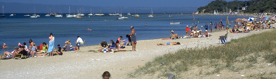
Frankston is a city on the Mornington Peninsula which is now part of Greater Melbourne. Located on the eastern shore of Port Phillip Bay and is set against Olivers Hill, it has been described as the 'Gateway to the Mornington Peninsula'. It is a delightful bayside destination which is home to both holidaymakers, daytrippers and commuters. The surrounding area includes 7 km of beaches, excellent beachside walks, wild coastal bushlands, and superb parks and gardens. The city has significant historic buildings, theatres, galleries, restaurants, botanic gardens, a pier and caters for visitors wanting to go swimming, fishing, waterskiing and yachting. It is also rich in art with outstanding murals and impressive public sculptures. The city of Frankston, which includes Seaford, Carrum, Carrum Downs, Langwarrin and Baxter has a population of nearly 150,000.
Location
Frankston is located on the eastern shore of Port Phillip Bay 56 km south of the city centre via the M1 and M3.
^ TOPOrigin of Name
Most theories about the name insist that the settlement was named after a man named Frank. One contender is Wilburham 'Frank' Liardet who established the 'Ballam Ballam' estate in 1843. Another is that, in the 1850s, a man named Frank Stone owned the pub at the mouth of Kanahook Creek and the settlement grew around the pub.
^ TOPThings to See and Do
Foreshore Waterfront
Located at Pier Promenade, Frankston Waterfront is a pleasant, narrow sandy beach edged by parklands with a children's playground as well as ideal picnic and barbecue facilities. To the south lies Oliver's Hill Lookout and there is the Frankston Pier which juts out into Port Phillip. There is an excellent boardwalk along the foreshore which is noted for its interesting and impressive public sculptures.
Murals and Street Art
The excellent Frankston City Guide (available at the Visitor Centre) is sensibly divided up into "Murals, Street Art and Art Galleries", "Sculptures", "Nature Reserves and Gardens" and other categories. It has easy to follow maps, illustrations and descriptions which allow visitors to explore the 32 murals (16 of which are in the city's CBD) which make walking around Frankston such a hugely enjoyable experience.
The ones in the centre of the city include:
1. Alice in Wonderland and Nutcracker - Frankston Library (see photo)
2. Stacked Bookshelves - Frankston Library (see photo)
3. Untitled - 60 Playne Street
4. Untitled - 126 Young Street
5. Untitled - Park Lane (see photo)
6. Untitled - Thompson Lane
7. All The Green Year - Thompson Lane
8. Plover Lover - 1 Keys Street
9. Students Against Graffiti - Wells Lane
10. The Graceful Ascent - Ross Smith Avenue
11. All This Mayhem - 20 Olsen Street
12. Flower Girl - Ross Smith Lane
13. Counterbalance - 33 Beach Street
14. Utility Boxes - Young Street
15. Life Savers - 37 Davey Street
16. Mary Jane - Gallery Lane
Sculptures
Frankston is awash with public sculpture. There are 16 works in the City Centre (see images of Sight Line and Crab Riders) and located 6 km east of Frankston at 390 McClelland Drive, Langwarrin is the McClelland Sculpture Park + Gallery with its superb displays of sculptures. It is recognised as one of Australia’s leading sculpture parks. Again the Frankston City Guide has a map and details of all the major sculptures in the CBD.
Olivers Hill
Oliver's Hill was named after a local fisherman who used to scan the bay for fish from this spot. There is a lookout at the car park which offers outstanding views of Port Phillip, Melbourne and the Dandenong Ranges. The lookout lies to the south of the Frankston Foreshore Reserve on the Nepean Highway.
Frankston Nature Conservation Reserve
Located at 53 Lawson Avenue, Frankston South (the entry is via Jeremy Way, Frankston South) and open from dawn to dusk, the Frankston Nature Conservation Reserve is a 98 ha park which is home to over 300 species of native plants and animals including the Growling Grass Frog, Echidnas, Blue Tongue Lizards and the Blue Billed Duck. It is ideal for bushwalking, cycling, picnics and barbecues. Check out https://www.visitfrankston.com/frankston-nature-conservation-reserve for more information. There is a Parks Victoria Visitor Guide with an excellent map which can be downloaded at https://parkweb.vic.gov.au/__data/assets/pdf_file/0006/721590/FrankstonNatureConservationReserveVisitorGuide.pdf.
George Pentland Botanic Gardens
Located at the corner of William Street and Yuille Street, the George Pentland Botanic Gardens, opened in 1975 and now home to an extensive array of native Australian plants, have wide open expanses of manicured lawn, a children's playground, a duck pond/ornamental lake, a boardwalk, picnic-barbecue facilities, shady trees and native gardens. They are popular for family gatherings and weddings. There is also a short, pleasant walking track. They are an easy walk from Frankston Pier. There is a useful brochure, complete with a map, which can be downloaded by going to https://www.frankston.vic.gov.au/Things_To_Do/Parks_and_Reserves/Frankston/George_Pentland_Botanic_Gardens and clicking on the "Related Documents".
Ballam Park Regional Playground
Located at 316 Cranbourne Road, Ballam Park Regional Playground has an athletics track, football field, junior soccer field, basketball half-court and cricket pitch and is the home to the local Long Island Cricket Club, Peninsula Strikers Junior Football Club, Karingal Football and Netball Club and the local Ballam Park Scout Group. It is a huge open space designed for sports and leisure and there are good places for picnics and for leisurely walks. Check out https://www.visitfrankston.com/ballam-park-regional-playground. Of particular significance is the Ballam Park Homestead.
Ballam Park Homestead
Located on Cranbourne Road in Ballam Park, the Ballam Park Homestead was the first brick house to be built in the district. It was constructed for Wilburham 'Frank' Liardet and built between 1847-1854 by tradesmen, convict labour and Liardet's two sons. Liardet's mother was descended from English diarist John Evelyn and had been lady-in-waiting to Queen Victoria.
The two-storey homestead is built in the manner of a French farmhouse with a fine cedar and mahogany staircase, leadlight sashes and deep bow windows which were all imported from France. The timber veranda features a gabled porch with four-leafed-clover decorations and there is an attractive attic. During the first generation of ownership a lantern was always suspended from the highest window to act as a beacon for ships in the bay and bullock wagons in the bush. Bricks made on the Ballam Park Estate were used to build several hotels at Port Melbourne.
Ballam Park Homestead, now operated by the Frankston Historical Society, is open to visitors with Liardet family artefacts on display, including a buggy, a blacksmith's forge and a farm machinery display. A separate building has been set up as a museum of Frankston and district. There are also tea rooms which are open every Sunday from 1.00 pm to 5.00 pm. There are guided tours through the house each Sunday from noon to 3.00 pm, tel: 0449 858 316 or check out http://www.frankstonhs.org.au.
Beauty Park
Located at 51 High Street, Beauty Park is a delightful combination of an ornamental lake with viewing platforms (where birds abound); a huge children's playground; a sandstone pavilion with barbecue and picnic facilities; a pleasant walking and cycling path which circumnavigates the park; and an impressive sculpture by Deborah Halpern which was installed in the park in 2002. Check out https://www.visitfrankston.com/beauty-park for more details.
Langwarrin Flora and Fauna Reserve
Located at 233 Warrandyte Road, Langwarrin (and accessed from McClelland Drive) this 214 ha reserve of heathland and eucalypt woodland is so rich it is home to half the plant and animal species on the Mornington Peninsula. There are over 300 indigenous plants in the reserve. In 1886 a military reserve was established on this land and used for manoeuvres and as a rifle range. German POWs were kept here in World War I and a hospital was created to treat veterans returning from Europe with venereal disease. At that time there were many buildings and roads and a large drainage system. At the end of the war most buildings were dismantled and the reserve was used for grazing. It was declared a reserve in 1985.
Today it is ideal for bushwalking, cycling, horse riding. It has no picnic or barbecue facilities. Of particular interest is the Langwarrin Historical Trail which is 3 km long and takes around one hour return. Signs along the walk tell of the military use of the area.
Plant communities include open stringybark forest and some remnant plant types which are now virtually extinct on the peninsula, including tufted blue-lily, rabbit-ears orchid, wedding bush and short purple-flag. The reserve also contains 98 bird species and a range of small mammals including koalas, swamp wallabies, brown bandicoots and the rare New Holland mouse. There is a useful, downloadable Visitor Guide with a detailed map. Check out https://parkweb.vic.gov.au/__data/assets/pdf_file/0003/720912/Langwarrin-Flora-and-Fauna-Reserve-Visitor-Guide.pdf.
Seaford Wetlands
Located on Austin Road, Seaford, 4 km north of Frankston, the Seaford Wetlands is a 305 ha nature reserve which features river red gums which predate European colonisation and a number of rare and endangered migratory bird species. There is a walking/cycling track with a viewing platform and an elevated bird hide. It is the largest remnant wetland around Port Phillip. Check out https://www.visitfrankston.com/seaford-wetlands for more information.
Sweetwater Creek Reserve
Located at 28 Fenton Crescent, Frankston South with a carpark at the foot of Olivers Hill, Sweetwater Creek is a 14 ha bushland reserve at the base of Olivers Hill. The reserve features rare surviving examples of pre-colonial vegetation. It is based around Sweetwater Creek which was used by the Aborigines and early European settlers as a water source. There is a well established walking trail around the perimeter of the wetlands. Check out https://www.visitfrankston.com/seaford-wetlands.
The Pines Flora and Fauna Reserve
Located at Excelsior Drive, Frankston North, this 108-ha inland sand dune reserve is an area of remnant bushland (it contains 210 indigenous flora species) which is an important habitat for small mammals, reptiles and amphibians. The springs were once used by the Bunurong Aboriginal people. In the 1920s about 120 ha were planted with pine trees. A proposal in the 1970s to establish sand mining met with fierce and successful resistance and it has now been zoned as public open space. There are no facilities but there are a network of tracks including:
* Orchard Circuit - 3 km, 45 minutes - a short, easy walk through an area that was once an orchard and is now being regenerated.
* Boggy Creek Circuit - 3.5 km, 75 minutes - a walk through the bushland dunes and along Boggy Creek.
* Panorama Circuit - 6.2 km, 105 minutes - walk through the dunes to a lookout with fine views of the Dandenongs and Port Phillip Bay.
Parks Victoria have a useful Visitor Guide (with a good map) which can be downloaded at https://parkweb.vic.gov.au/__data/assets/pdf_file/0008/726956/The-Pines-Flora-and-Fauna-Reserve-visitor-guide.pdf.
Walking trails and cycle paths
Frankston Waterfront Boardwalk
Starting at 555 Nepean Highway, the Frankston Foreshore and Pier Walk is a 3 metre wide raised timber boardwalk which stretches from Oliver's Hill in the south to Wells Street in the north. It offers superb views across Port Phillip Bay. Check out https://www.visitmorningtonpeninsula.org/PlacesToGo/Walks/AllWalks/tabid/399/View/5b025d2191da27d630bec0e4/Frankston-Foreshore-and-Pier-Walk/Default.aspx for more information.
Frankston to Baxter Trail
A 7.5 km shared cyclists and walkers route which starts at Frankston Waterfront and finishes at Golf Links Road. It is pleasantly free from traffic and its most notable attraction is the Langwarrin Flora and Fauna Reserve. There is a detailed map at https://www.visitfrankston.com/frankston-to-baxter-trail.
Kananook Creek Walking Trail
This 7.5 km walking trail starts at the Frankston Yacht Club and heads north following Kananook Creek to Seaford Foreshore Reserve and Carrum. It is a delightful walk beside the creek and, at the mouth of the creek, there is an interesting public artwork on the pillars beside the Landmark Bridge which uses the text from the poem, I Kananook. It was created by Evangelos Sakaris. Check out https://www.visitfrankston.com/ikananook-art-installation for more information about the poem.
Seaford Foreshore Reserve Walking Trail
The 5 km long Seaford Foreshore Reserve Walking Trail runs from Keast Park to Mile Bridge through the coastal dunes behind Seaford Beach. The excellent and detailed Weekend Notes on the walk (see https://www.weekendnotes.com/seaford-foreshore-reserve-walking-track) notes: "Of particular importance is the Coast Banksia Woodland, described as the finest example of this woodland type in Melbourne, as much of this vegetation has been cleared around the coastal strip of Port Phillip Bay. Other common plant species include Coast Tea-tree, White Correa, Coast Beard Heath and Coast Daisy-bush." Of particular interest is the unusual sculpture/installation named "The Hermitage" which is located on the walk near the Seaford Pier car park. It was created by Jacki Staude to honour a local hermit, John Maddox, who created a fantasy world of shells, bottles and driftwood. He lived by selling his fish to the locals and he died in 1917.
Peninsula Link Trail
This is a major 25 km track which begins at Patterson Lakes and finishes at Moorooduc and passes through wetlands, parklands and bushlands. There is detailed information at https://www.visitfrankston.com/peninsula-link-trail - it lists a total of six trips along the Link Trail from the 25 km walk to shorter 2 km walks. There is a detailed map which can be downloaded at https://www.peninsulalink.com.au/Images/ContentEditor/Documents/Shared%20Use%20Path%20Info%20Sheet.pdf.
Other Attractions in the Area
McClelland Sculpture Park + Gallery
Located 6 km east of Frankston at 390 McClelland Drive, Langwarrin, the McClelland Sculpture Park + Gallery, one of Australia’s leading sculpture parks, is set in 16 ha of bushland and surrounded by lakes and gardens. There are over 100 outdoor sculptures by some of Australia’s leading sculptors. The McClelland Café, with a small but classy menu, overlooks the lake. The Gallery is open Tuesday to Sunday from 10.00 am - 5.00 pm and the cafe is open Tuesday to Sunday from 10.00 am - 4.30 pm, tel: (03) 9789 1671. Check out https://www.mcclellandgallery.com for more information.
Cranbourne Botanic Gardens
Located on the corner of Ballarto Road and Botanic Drive, Cranbourne, and covering over 363 ha, the Botanic Gardens are open daily from 9.00 am to 5.00 pm. Entry is free. It is proud of the fact that it is an area of native bushland with untouched areas of heathland, wetlands and woodlands. The Australian Garden is notable for its stands of native flora and impressive sculptures as well as a rock pool waterway. Amongst its fauna and flora are 25 species which are listed as endangered or threatened. The gardens were purchased by the Victorian Government in 1970 and designed specifically to complement the Melbourne Botanic Gardens by specialising in native plants and ecosystems. The official site notes: "Visitors to Cranbourne Gardens can enjoy a natural bushland experience and visit the Australian Garden. Facilities in the bushland include over ten kilometres of walking tracks, six kilometres of cycling tracks, a lookout tower, picturesque shelters, barbecues and picnic tables. There is a range of visitor programs, as well as self-guided walks available throughout the year. The Australian Garden, completed in October 2012, celebrates the beauty and diversity of Australian landscapes and flora and features approximately 170,000 plants from 1,700 plant varieties. Complementing the Garden are a visitor centre, café, gift shop and interpretive displays." Check out https://www.visitfrankston.com/royal-botanic-gardens-cranbourne for more information.
Cruden Farm
Located at 60 Cranbourne Road, Langwarren, Cruden Farm is open from Monday to Friday from 10.00 am - 4.00 pm and occasional Sundays. It was owned by Dame Elisabeth Murdoch and was left (it is now managed by a charitable trust) so that visitors could come and wander through the manicured gardens, pass through the bushland and around the lake and lagoon. It has a remarkable story: in 1928 Keith Murdoch gave his 19-year-old bride, Elisabeth, a small farm which she turned into a weekend retreat. Over the years stables were built, Edna Walling was employed to design new gardens (including a walled garden) and "Beyond the formal gardens, lies the ‘outer garden’ and the stunning lake that Dame Elisabeth created in 1987. Behind the lake are numerous Oaks, some of which were planted by Dame Elisabeth’s daughters and grand-daughters in the late 1980s. Cruden Farm continues to evolve as a place with activities sympathetic to Dame Elisabeth’s long term plans for continual improvement." The website provides excellent information about opening times and special events. Check out https://www.crudenfarm.com.au or tel: (03) 9789 1676.
Mulberry Hill
Located at 385 Golf Links Road, Langwarren South (it is 7 km from Frankston) 'Mulberry Hill' is the former home of Joan Lindsay (the author of Picnic at Hanging Rock) and her husband, Sir Daryl Lindsay, the brother of the artist, Norman Lindsay. It is an American Colonial style weatherboard house on a hill in rural surrounds, offering views of Western Port Bay. The Lindsays inherited the original four-room 1880s cottage when they purchased the property from cousins of the painter Frederick McCubbin in 1926. The new, extended home was designed by Harold Desbrowe Annear as an extension to the original 1880s cottage. The property was originally part of the Carrup Carrup estate, established by Captain Baxter in 1840.
The Victorian Heritage Database (check out https://vhd.heritagecouncil.vic.gov.au/places/66231/download-report) notes of the garden: "Major garden elements include a large semi-circular cypress hedge with rockery under, the associated brick garden wall with cast cement urns, Italian cypress, pathways and hedges on the south, and an axial brick-paved walk focused on a sundial. The paved garden area to the rear has an enclosing garden wall made from slop moulded bricks and includes an old mulberry tree, from which the house derives its name. The property is entered via a curving drive lined with gums."
The National Trust website explains: "Sir Daryl Lindsay was Director of the National Gallery of Victoria from 1941 to 1956, and was knighted in 1957 for his services to Australian Art. A member of the famous Lindsay family of artists, he was an accomplished painter and print maker. He also assisted in founding the National Trust of Australia (Victoria) in 1956 and was its first president.
"His wife, Lady Joan Lindsay was an artist and writer, best known for her novel, Picnic at Hanging Rock. Her autobiographical novel Time without Clocks is about the Lindsay’s life together at Mulberry Hill and includes commentary about the arts and social history of the time.
"The house and its contents, a collection of Australian art, Georgian furniture and glassware and Staffordshire ceramics, was bequeathed to the National Trust by Sir Daryl and Lady Joan Lindsay."
Guests at the house included Vivien Leigh, Sir Robert Helpmann, Banjo Paterson, Sir Robert Menzies and Dame Nellie Melba. As both Lindsays were artists, there is, not surprisingly, a fine collection of art by the likes of the Lindsays, Frederick McCubbin, Rupert Bunny, John Perceval, Constance Stokes and Margaret Preston, as well as Georgian furniture, literary items and memorabilia. Joan Lindsay's writing room has also been preserved.
The house and property were bequeathed by Joan Lindsay to the National Trust which opens it to the public every Sunday from 11.00 am - 4.00 pm. Tours for groups can be organised, tel: (03) 5656 9889. Check out https://www.nationaltrust.org.au/places/mulberry-hill for further details.
Coastal Arts Discovery Trail
There is an excellent, very detailed, 29 page brochure - Coastal Arts Discovery Trail - which can be downloaded at https://www.visitfrankston.com/images/documents/CoastalArts.pdf. This initiative, "designed to capture the stories, images and ideas that acknowledge and celebrate local culture from the time of the original inhabitants through to the present day", includes:
*Davey's Bay
* Gulls Way
* Oliver's Hill
* Walter Burley Griffin's house, Gumnuts, at 619 Nepean Highway, Oliver's Hill
* Yamala and the Burley Griffins
* The Round House, 581 Nepean Highway, Frankston
* Frankston Pier and the sculptures
* Kananook Creek
* Palm Court, Long Island
* Rick Amor and the Roadside Marker
* Indigenous stories
* The Seaford Hermit and Hermitage
History
* The Bunurong Aborigines used the area on a seasonal basis for thousands of years before the arrival of Europeans.
* The first European person to occupy land in the Frankston area was a man named John Thomas Smith c.1836.
* Wilburham 'Frank' Liardet established the 'Ballam Ballam' estate in 1843 and built a home which is still standing to the east of town.
* About 1846 James Davey took up a large holding which extended from Mount Eliza to what is now known as Olivers Hill.
* Thomas McComb, who came to Frankston in 1852, did much to develop the local fishing industry.
* In 1850 Victoria was declared a separate colony to New South Wales and surveys of the area were conducted.
* In the 1850s, a man named Frank Stone owned the pub at the mouth of Kanahook Creek around which the settlement developed.
* The first official land sales occurred at Frankston in 1854.
* A pier was completed in 1857 although additions continued until 1866.
* A school was established within the first Anglican church in 1855.
* The first Frankston post office was opened in 1857.
* A pottery was established in 1859.
* In the 1860s there were about 30 people at Frankston with about 200 in the surrounding area.
* The first state school was built at Frankston in 1874.
* A mechanics' institute and free library was opened in 1880.
* By 1880 two brickworks and a cordial factory were operating.
* The first savings bank opened in 1881.
* When the railway arrived in 1882, Frankston gradually became a holiday resort for people from Melbourne.
* A bacon factory opened in 1889.
* In 1928 Keith Murdoch bought Cruden Farm for his new bride, Elisabeth.
* Frankston was declared a city in 1966.
^ TOPVisitor Information
Frankston Visitor Information Centre, Frankston Waterfront, 7N Pier Promenade, tel: 1300 322 842, Open 9.00 am - 5.00 pm seven days a week.
^ TOPUseful Websites
There is a very detailed local website. Check out https://www.visitfrankston.com.
^ TOP