Hugely important industrial centre and port on the Capricorn Coast.
Although Queensland, unique amongst Australian states, has a series of major regional centres along its coast (Bundaberg, Rockhampton, Mackay, Townsville, Cairns) only Gladstone feels like a genuinely industrial city. The NRG Power Station, the huge port, the Queensland Alumina Ltd operation to the south of the city, the RG Tanna Coal Terminal, the Cement Works, the Gladstone Ports Corporation all make it one of the most substantial and commercially successful ports in Australia. More than 100 million tonnes of cargo with over thirty products pass through the port each year. In the last three decades this quiet port has become a maritime centre with some of the most sophisticated loading facilities in the country. In this sense it is worth visiting but, most of all, it has its own visitor attractions - impressive lookouts, nearby beaches, a beautiful Botanic Gardens and easy access to the southern reaches of the Great Barrier Reef.
Location
Gladstone is located 518 km north of Brisbane via Highway 1 and 108 km south east of Rockhampton.
^ TOPOrigin of Name
Gladstone is one of the many towns and cities in the British Empire which were named after William Ewart Gladstone. It was named in 1846 when he was the British Colonial Secretary. He later became Prime Minister of Great Britain - four times.
^ TOPThings to See and Do
Gladstone City Heritage Walk
Unlike Rockhampton or Bundaberg, Gladstone is not a Queensland city known for its large number of elegant buildings. Consequently the Gladstone City Heritage Walk is a pleasant 2 km walk which will take about 35 minutes. It can be downloaded at http://tourism.racq.com.au/__data/assets/pdf_file/0004/62293/Gladstone-City-Heritage-Walk-Sept-2012.pdf.
The walk involves seven stages and the main attractions are the Grand Hotel (built in 1897, destroyed by fire and faithfully restored with the upper storeys being particularly impressive); the Heritage Tree (it is clearly signposted on Roseberry Street) a beautiful old fig tree with roots dropping from the branches; the Golding Lookout which offers a superb overview of the city's marina, the harbour and the wharf facilities - there is a directional guide which helps the visitor to identify the islands off the coast; and the walk then descends the hill to Auckland Inlet where there are remnants of wharves and stores dating from the 1860s. Making your way back to the city centre you will understand why the city does not have a lot of historic buildings. The major buildings in Yarroon Street are modern and elegant with the notable exception of the decidedly quirky (complete with town clock) Old Gladstone Post Office, although it does date from 1932.
Gladstone Regional Art Gallery and Museum
The Gladstone Art Gallery and Museum was opened in 1985. It is located in the handsome Old Town Hall at 136-144 Goondoon Street and is open from 10.00 am - 5.00 pm, tel: (07) 4976 6766. Check out http://gragm.qld.gov.au for exhibitions and other information. The gallery hosts travelling art exhibitions and the museum "is a social history museum that houses an extensive Heritage Collection. Included in the collection are articles and photographs of cultural significance to the Gladstone Region."
Auckland Hill Lookout or Golding Lookout
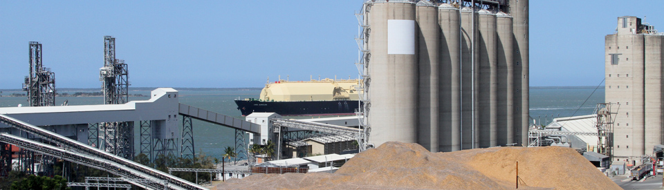
This is an opportunity to enjoy a panoramic view over the port as well as an opportunity to understand just how much of an industrial centre Gladstone is. The port has a total of four wharves and the Auckland Point Wharves handle "imports of petroleum products, magnate, copper slag, break bulk cargo, cement gypsum, LP gas, caustic soda, containers and general cargo." They also handle exports of "calcite, scrap metal, electro-fused magnesia, magnesia, break bulk cargo, grain, containers and general cargo". Of course 70% of all cargo is coal but of the others, as the excellent brochure available at the Visitor Information Centre points out, "calcite, high quality limestone ... is stockpiled at Auckland Point for final shipment to Geelong where it is used as a filler in plastics, paper glossing and toothpaste." The port also exports "wheat, sorghum, maize and oil seeds from Biloela and Emerald areas to India, Iran, Japan, New Guinea, South Africa and South Yemen".
Round Hill Lookout
Located at the end of Boles Road the Round Hill Lookout offers the best overview of Gladstone and all its industries. To the south is Boyne Island and Tannum Sands; the east looks towards the city's harbour and the north encompasses the city centre and the islands; and to the west lies the city's ever expanding suburbia.
Queensland Alumina Ltd Lookout
Each year Queensland Alumina Ltd refines 9 million tonnes of bauxite mined at Weipa on Cape York to produce 3.95 million tonnes of aluminium. That is 10% of the western world's demand. The production of aluminium requires huge amounts of electricity and thus the power station (fuelled by coal from the mines at Blackwater, Moura and Callide) produces a huge percentage of the state's electricity. The company has established a special lookout above the works (it is accessed from Agnes Street) with detailed information about the processes and a directional guide which identifies the major parts of the plant.
Tondoon Botanic Gardens
The beautiful Tondoon Botanic Gardens are located 5.4 km south of the city centre along Glenlyon Road. Completed in 1982 and officially opened in 1988, they cover 55 ha and include lakes (Lake Tondoon), cascades, some interesting sculptures, a Japanese garden (the Garden of Stillness and Movement), an herbarium and arboretum and an interpretative nature trail with information about the birds in the lakes. The gardens specialise in tropical and subtropical plants with extensive gardens of pandanas, cycads, banksia, hoop pine vine, proteas, and xanthorrhoea. Check out http://www.gladstone.qld.gov.au/tondoon-botanic for more details. It is open from 7.15 am - 4.00 pm and is a delightful retreat from the heat and industry of the city. There is a cafe in the gardens.
Other Attractions in the Area
Calliope River Historical Village
The Calliope River Historical Village is located 29 km south-west from Gladstone on the Bruce Highway. It is impossible to miss. Positioned just over the Calliope River, on the western side of the highway, it is a fine collection of early buildings from the local area including the Clyde Hotel, Barmundoo Homestead, Wright's Cottage, the Raglan Dance Hall, Larson House, Curtis House, the Ambrose railway station, Many Peaks Masonic Lodge Hall, the Hazeldean Presbyterian Church, and an historic slab hut. The village is well laid out and it is easy to get a copy of the very detailed description of each of the buildings - here is an example: "The Slab Hut - This area, about 100 years ago, was an important gold mining district. Hundreds of miners came from many parts of Australia to try their luck. They lived in tents and shanties. At the same time graziers settled here to provide the meat for the miners to eat. As graziers were permanent, they built for themselves houses that would last. This particular house was built in a goldrush area about 70 kilometres from here, right out in the bush. To buy timber or bricks was difficult and very expensive so they made their houses out of split logs smoothed off with an adze. Many had dirt floors, but this one has a slab floor, which keeps beds and tables away from the damp. You can see by the cracks in the floors and walls that in winter time the wind would blow in and they were very cold. Mostly they stuffed these cracks with paper. Some graziers would build their roofs with wooden shingles also split from trees. However, corrugated iron became available about the time this house was built in the late 1890s so it was used instead as it kept the rain out much better. Generally the houses were quite cool in summer and although people didn't have much time to relax they used the deck chairs and would sit in them on the veranda and talk with friends whenever they had time to visit." and make your way around at your leisure. The village is staffed entirely by volunteers and is open daily from 10.00 am - 4.00 pm. It is also home to a regular Country Market on the weekends, tel: (07) 4975 6764. Check out http://callioperiverhistoricalvillage.com/ for more detailed information.
Lake Awoonga
Lake Awoonga is located 33 km south of Gladstone via the Bruce Highway and Awoonga Road. It is 8 km from the Bruce Highway. Stage 1 of the Awoonga High Dam was opened in 1985 and Stage 2 in 2003. It is the main water supply for the Gladstone region as well as being a hugely popular recreation area known for its lake and mountain views, its outstanding fishing, its popular caravan park and its numerous shelter sheds and barbecues, walking paths and playgrounds.
Enthusiastic anglers come to Lake Awoonga to catch the famed barramundi, of which the sign at one of the lookouts announces that 2,668,350 have been released into the lake. (It is now up to over 4 million) The largest caught weighed in at 36.5 kilograms. As well as barramundi, 469,660 sea mullet, 78,003 yellowfin bream and 70,942 mangrove jack are stocked in the lake. Lake Awoonga is the highest stocked lake in Australia for Mangrove Jack.
It attracts locals and visitors because it is huge and peaceful. It is the ideal place to relax and enjoy the beautiful scenery and wildlife. Plants in the water and river banks support the fish, eels, turtles, platypus and birds. Further from the water's edge snakes, geckos and lizards, frogs and mammals can be found.
The nearby bushland holds a diverse range of native fauna. Bandicoots, melomys, kangaroos, greater gliders and yellow bellied gliders, and brushtail possums. Wallabies such as the agile, whiptail and swamp wallaby can be spotted by keen observers. Two fauna species are listed as vulnerable: the yellow-bellied glider and the grey-headed flying fox.
For "twitchers", Lake Awoonga is a paradise with more than 225 species or over 27% of Australia's bird species found in the region. The southern squatter pigeon is listed as vulnerable and twenty-seven species are listed on International Migratory Conservation Agreement lists. Lake Awoonga is arguably one of the most important near-coast bird refuges on the East Coast of Australia. There is a useful brochure on Lake Awoonga which can be downloaded at http://www.gawb.qld.gov.au/documents/40241572/40255094/Lake_Awoonga_Brochure.pdf.
Quoin Island
Located 5 km off the coast from Gladstone is Quoin Island which lies at the entrance to Port Curtis. It is a sanctuary from the industry of the city with clean beaches, bushwalking, and facilities for windsurfing, swimming, fishing and boating. The Quoin Island Retreat and Rehabilitation Centre offers conference facilities and the Turtle Rehabilitation Centre is dedicated to the rescue, rehabilitation and release of ill and injured sea turtles. For information and bookings contact tel: (07) 4970 0123 or check out http://www.gladstoneregion.info/destinations/quoin-island/attractions/quoin-island-retreat-and-turtle-rehabilitation-cen. The island can be accessed from Gladstone by ferry.
Curtis Island
Located 16 km from Gladstone, Curtis Island is 40 km from north to south and 20 km from east to west. It was first sighted by Captain Cook during his voyage up the coast in 1770. In 1802 Matthew Flinders named it after Admiral Sir Roger Curtis, the Commander-in-Chief at the Cape of Good Hope. In recent times part of the island has been developed as a liquid gas and coal port but it still has a National Park section to the north which, as the Gladstone Region website rather floridly explains "offers stunning unspoilt beaches, intimate north-facing bays, sparkling ocean, the Great Barrier Reef, wilderness, wetlands as well as an outback-style cattle station. It even has its own airstrip." Check out http://www.nprsr.qld.gov.au/parks/curtis-island where there is an excellent map of the National Park sections of the island.
Mount Larcom Climb
Located 32 km north west of Gladstone, Mount Larcom is visible from most points in Gladstone. Its summit is 632 metres above sea level.
Matthew Flinders observed it and named it after Captain Larcom under whom he had served. Because of its profile, it is often call "The Lion Mountain". It is said to resemble a lion and lioness facing each other. There is a good track to the top which takes around 2 to 2 1/2 hours (ie 5 hours up and back). The reward is a 360-degree view of the Gladstone area, rural lands and the harbour. On a clear day, you will see reef islands to the east and Rockhampton northwards. Mt Larcom is of volcanic origin, and your walk takes you through light eucalypt forest and grass trees. It is a challenging walk, and best climbed in the cooler months, with an early start to capture the best views. It is advisable to check the local weather condition on the day of your climb as the peak can be shrouded in cloud. Check out http://www.gladstoneregion.info/destinations/mount-larcom/attractions/mount-larcom-climb for additional details. There is an excellent and useful description of the climb at http://www.gladstonelife.com/mt-larcom-hiking-tips-gladstones-mountain-adventure.
History
* Prior to the settlement of Europeans the area around Gladstone was occupied by the Gureng Gureng Aboriginal people.
* The Gladstone coastline was first explored by Captain Cook in 1770. He sighted and named Bustard Head to the south of the city at Town of 1770.
* In 1802 Matthew Flinders reached the area and named Port Curtis after Sir Roger Curtis, the Commandant of the Cape of Good Hope.
* In 1823 John Oxley explored the coastline.
* In 1848 Owen Stanley surveyed the entrance to the port.
* The first settlement of Gladstone occurred in 1847. It was basically a penal colony (200 convicts formed the majority of the population) but it was closed down by 1848.
* In 1853 Port Curtis, now known as Gladstone, was surveyed.
* In 1854 Governor Charles Augustus FitzRoy sailed the HMS Calliope up the river and named the river after the vessel. That year lots were sold in the town.
* It was around this time that free settlers moved into the area.
* By 1856 the town had a population of 200.
* A customs office was established in 1860.
* Through the 1860s it was promoted as a future capital for a newly established colony of Queensland.
* In 1863 it was declared a municipality.
* The town's first school was opened in 1864.
* A Presbyterian church was consecrated in 1869.
* Gladstone's first wharf was built at Auckland Point in 1885.
* A local hospital opened in 1890.
* The town was connected to Brisbane by rail in 1896.
* By 1903 the town's population was around 1,500.
* 1906 saw the opening of the Port Curtis Dairy Cooperative.
* In the 1930s Heron Island became a local tourist destination.
* The Town Hall was completed in 1934.
* By 1948 Gladstone was the main port for coal from the Callide Valley.
* By 1960 Gladstone had a population of 7,200 and its economy was dependent on its importance as a port.
* In 1961 the export of coal from the Moura fields to the west resulted in a huge increase in both population and port activity.
* In 1967 production of aluminium began at the Comalco aluminium works. The Gladstone power station opened that year.
* In 1968 a railway line from Moura to Gladstone opened. It was primarily for shipping coal to the coast.
* By the 1970s the town's population had doubled and the port was handling 10 million tonnes per annum.
* A major power station was established in 1971.
* In 1976 Gladstone was proclaimed a city.
* The Clinton coal facility was opened in 1980.
* The building of the Boyne Aluminium Smelter was completed in 1982.
* In 1983 Gladstone became the first Queensland port to handle over 20 million tonnes of cargo - most of it coal and alumina.
* In 1988 the Tondoon Botanic Gardens opened.
* A chlorine and cyanide plant opened in 1989.
* By 1990 it was handling over 29 million tonnes per annum, was the second largest port on the Australian east coast, and was capable of providing a safe port for ships of 200,000 tonnes. It occupied 18 km of foreshore.
* In 2011 the city's population was 32,000.
* In 2015 the first shipment of liquified gas left for Asia from the Gladstone port.
^ TOPVisitor Information
Gladstone Visitor Information Centre, Marina Ferry Terminal, 72 Bryan Jordan Drive, Gladstone, tel: (07) 4972 9000.
^ TOPUseful Websites
The Regional Council has a useful website. Check out http://www.gladstone.qld.gov.au and the Southern Great Barrier Reef website has useful suggestions. Check out http://www.gladstoneregion.info.
^ TOP
No mention of the Brisbane to Gladstone Yacht race,for many years Gladstone’s main claim to fame.
Show some Vimeo videos of the area. Better than all of these word. A picture tells a thousand …….?
I think this city offers a unique blend of industry and natural beauty, with its bustling port and proximity to the Great Barrier Reef.
We only spent one night in Gladstone – wish I’d read this first. Worthy of much more time. Staggering amount of industry. Auckland Hill Lookout currently closed, except for pedestrians.