Major commuter destination on the New South Wales Central Coast
Located at the northern end of Brisbane Water, Gosford is the commercial and administrative centre of the City of Gosford which covers 1029 square kilometres. The sprawling city is at the heart of the New South Wales' Central Coast. It attracts retirees, commuters and young families drawn by the mild climate, the ocean beaches, the bushland and forests and the easy access to Sydney by means of the Pacific Motorway and the fast electric train service. To the west the city is edged by rugged terrain and extensive state forests. The Tuggerah Lakes lie to the north. Although tourism now dominates it has a strong agricultural and industrial base with citrus orchards, chickens, fishing, oysters, vegetables, plant nurseries, cut flowers and forestry.
Location
Gosford is located at the northern end of Brisbane Water, 10 m above sea-level and 77 km north of Sydney via the Newcastle Freeway and Pacific Highway.
^ TOPOrigin of Name
Gosford was named by Governor Gipps after Archibald Acheson, 2nd Earl of Gosford, who had served with Gipps in Canada. There had been a private town which was replaced by a government town in 1839. This town was originally called Point Frederick in honour of Frederick Hely but Governor Gipps crossed Point Frederick out and wrote in "Gosford" ... and so on a whim, it became Gosford.
^ TOPThings to See and Do
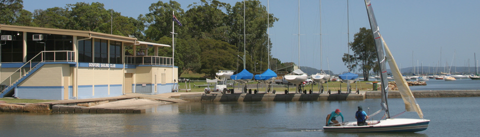
Gosford Waterfront Walk
There is a delightful 2.4 km return walk along the foreshore of Brisbane Water. It is a pleasant and simple walk with gardens on the main road side and a sealed path wide enough to include cyclists and skate boarders. There are excellent picnic areas and the view across the water is panoramic and dotted with boats and yachts.
Old Gosford Courthouse
Located on the elevated land near the corner of Mann Street and Georgiana Terrace, the Old Gosford Courthouse is now the oldest public building on the Central Coast. It was designed by much-admired colonial architect Mortimer Lewis and built in 1848-49 of local sandstone to replace the original 1827 watch-house which had fallen into disrepair. it consists of three linked single-storey elements made principally of sandstone. The original shingle roof has been replaced. For more detailed information check out http://www.environment.nsw.gov.au/heritageapp/ViewHeritageItemDetails.aspx?ID=1620048 which provides a history of the building and the architect. The very detailed description notes: "Building complex of sandstone in elevated corner position on main road of Gosford City. In close association with municipal offices and the Old School of Arts. Front of Old Courthouse has a steel fence and garden bed with mature trees that screen the facade. New courthouse addition has alignment on footpath as does the south facade of the Old Courthouse. The Old Courthouse has a rectangular plan with hip roof and awning roof over verandah along front facade. Verandah has timber posts and cast iron brackets. Walls are rough cut regular sandstone blocks. Concrete steps to front. Timber framed, multi-paned double hung windows. Timber soffits to eaves. Cast iron decorative vents to south facade. Sub floor stone walls deteriorated. Brick extension to rear. New Courthouse is L-shaped with gable roof to front and hipped at rear. Decorative barge boards and detailed stonework around circular vent to top of gable end. Three timber framed elongated double hung windows to front facade. Ashlar sandstone with picked finish structure on rough faced sandstone base. Timber framed, hipped wing to south facade adjoining Old Courthouse, possibly enclosed verandah. Rendered chimney with terracotta pots to rear."
Christ Church
A little further south along Mann Street is Christ Church. It is now a large, modern building but beside it is a simple and attractive structure which was originally built in 1857-58 at the corner of Webb and George Streets in East Gosford. At the time it was the busiest part of Gosford due to the ease of access by boat. In 1906 the building was moved to Mann Street. This move reflected a shift in the settlement's centre. It became a rectory when rebuilt and is now the church hall.
Gosford Regional Gallery and Edogawa Commemorative Garden
The Gosford City Art Centre has a beautiful Japanese garden, the Edogawa Commemorative Garden, which was established by Gosford's sister Japanese city, Edogawa. There are few places which can match a formal Japanese Garden for peace and tranquillity. The brightly coloured koi carp swimming lazily in the ponds edged by lotuses and water lilies. The exquisite Japanese maples and cherry trees. The kare-sansui or dry stone gardens with their precisely raked stones. The arching timber bridges and the cool beauty of the Tea House. The walks through wisteria and beside Chinese elms and evergreen alder trees. A great Japanese garden is a masterpiece of precisely constructed and integrated elements.
Located at 36 Webb Street, East Gosford the local council has decided to combine the Gosford Regional Gallery complex with the Edogawa Commemorative Garden. This means that visitors – entry to both the garden and gallery is free – can pass from contemporary art into the timeless world of a Japanese garden. Visitors can walk through the garden admiring the plants and the superb setting or can sit on the many benches and simply enjoy the tranquillity. Japanese gardens are constructed so that, although small, every few steps offers a new vista. And every vista is composed like an oriental painting – precise and perfect in every detail. The gardens and gallery are open from 9.00 am - 5.00 pm daily. There is a café and brasserie in the complex. For detailed information check out http://www.gosfordregionalgallery.com or contact the Centre on 02 4325 0056.
Ken Duncan Gallery
Over the past two decades Ken Duncan has established himself as one of Australia's foremost landscape photographers. This gallery, located at 414 The Entrance Road, Erina Heights, is a combination of cafe, theatre and gallery. It is open from 10.00 am daily, check out http://www.kenduncan.com/ for more details.
Katandra Reserve
Together with Rumbalara Reserve, Katandra Reserve is 53 ha of outstanding bushland very close to the centre of Gosford. The two areas are very similar in their physical features though Katandra is perhaps more striking and distinctive. Together they constitute one of the region's major attractions.
There is an outstanding walking guide, with very complete details and maps, available at http://www.wildwalks.com/bushwalking-and-hiking-in-nsw/katandra-reserve. It is an essential for anyone planning to do any of the walks. An example, to tempt you to download all the details: "St John's Lookout - 166 m return, 10 minutes, very easy, rises only 13 metres. "This is a very short walk across the picnic area to the lookout – you can see the end of the walk from the start. The council has installed a sandstone footpath that arcs around the picnic area and leads to St Johns Lookout. The path also leads to picnic tables and accessible toilets. You will also find electric BBQs, just off the path. A great spot with some shade, the view from the lookout is great on a sunny day." Is there anything more you need?
Other walks listed and detailed include Seymour Pond (890 m return, 30 minutes, easy track); Guringai Track (1.2 km circuit, 45 minutes, moderate track); Graves Walk (1.5 km one way, 45 minutes, moderate track); Watermans Walk (1.6 km circuit, 45 minutes, easy track); Strangler Fig Walk (2 km return, 60 minutes, moderate track); Toomeys Walk (2.9 km one way, 90 minutes, moderate track); Mouat Trail (Katandra to Rumbalara) (4.1 km one way, 120 minutes, hard track); Katandra Circuit (4.8 km circuit, 135 minutes, moderate track), Katandra Reserve Explorer (5.3 km circuit, 165 minutes, moderate track) and Matcham to Gosford (8.5 km one way, 3 hours, 45 minutes, hard track).
One of the reserve's finest walking trails, Watermans Walk (1.6 km), starts at the Katandra Road entrance and winds along the northern edge of the reserve. It is easy going and makes a fairly dramatic transition from pleasant forest to dense canopied and very beautiful rainforest by Seymour Pond, which it circles. Watermans Walk links up with Toomeys Walk (2.9 km) which will take you to the St John Lookout at the western end of the reserve, or you can take Graves Walk (1.5 km) which runs along the southern end of the reserve from the Katandra Road entrance to the lookout. Situated on top of the ridge it offers panoramic views eastwards across the Matcham Valley and Erina Heights towards Terrigal and the ocean.
Rumbalara Reserve
The Rumbalara Reserve is located at the end of Dolly Avenue. There is an excellent overview map of both Rumbalara and Katandra Reserves (check out http://www.gosford.nsw.gov.au/docs/default-source/arts-culture-recreation/rumbalara-katandra-reserves-brochure-map.pdf?sfvrsn=2) which clearly indicates all the walks available. There is an outstanding walking guide, with very complete details and maps, available at http://www.wildwalks.com/bushwalking-and-hiking-in-nsw/rumbalara-reserve/. It is an essential for anyone planning to do any of the walks. An example, to tempt you to download all the details: "Ironbark and Flannel Flower Circuit - 2.1 km circuit, one hour, moderate, rises and falls 50 metres. "A great circuit walk, covering two of the popular walking tracks and some of the great sights in the upper section of the Rumbalara Reserve. You will enjoy some really nice forest walking and fantastic views across various parts of Gosford and the surrounding areas. Note that the entrance gate on Dolly Ave, for the upper section of Rumbalara, is locked at 8pm each evening." Is there anything more you need?
Other walks listed and detailed include Ironbark Loop (643 metres, 30 minutes, moderate track); Tottenham Place and Wannagan Lookout (900 metres return, 30 minutes, hard track); White Street Fire Trail (991 metres one way, 30 minutes, moderate track); Red Gum Walk (1.4 km circuit, 45 minutes, hard track); Flannel Flower Track (1.6 km circuit, 45 minutes, moderate track); White Street Rainforest Loop (1.7 km circuit, 45 minutes, moderate track); Ironbark and Flannel Flower Circuit, (2.1 km circuit, 1 hour, moderate track); Ouraka Point Loop (2.1 km circuit, 75 minutes, hard track); Rainforest Walk to Nurrunga picnic area (2.2 km one way, 1 hour, hard track); John Whiteway Drive to Tottenham Place (3 km one way, 90 minutes, hard track); Rainforest Walk (3 km return, 90 minutes, hard track); Upper Rumbalara Circuit (3.3 km circuit, 90 minutes, hard track); Rumbalara Explorer (6.1 km circuit, 2 hours 45 minutes, hard track) - Wild Walks says of the Rumbalara Explorer "Pretty well the grand tour of the Rumbalara Reserve, this walk takes in much of the great scenery the reserve has to offer. The walk covers both the lower and upper sections of the reserve and passes through the great variety of forest on show. The walk also passes three of the four bronze sculptures in the reserve. Yaruga picnic area would be a great spot to stop for lunch with it’s facilities and excellent views" and finally Gosford to Lisarow (11.3 km one way, 4 hours 30 minutes, hard).
Central Coast Steam Model Co-op
Located at Lot 10, Showground Road, Narara (off the Pacific Highway at North Gosford) is the Central Coast Steam Model Co-op which operates miniature train rides from 11.00 a.m. - 4.00 p.m. on the first Saturday of the month. There is a picnic area and refreshments are available. The tiny trains, which run on 7 1/4 inch (185 mm) and 5 inch (125 mm) gauge railways are powered by steam, electricity and small combustion engines. These are basically toy trains you can ride. They are huge fun ... particularly for children. Check out http://dazed.org/narara/index.htm for more details. They also have a Facebook page.
Forest of Tranquility and Australian Rainforest Sanctuary
Located at 390 Ourimbah Creek Road (which runs off the Pacific Highway at Ourimbah) is the award-winning Forest of Tranquility and Australian Rainforest Sanctuary. The sanctuary is situated in a valley densely covered in subtropical and temperate rainforest. It describes itself as "The Forest of Tranquility spans over 100 acres of virgin bush with an intact natural Australian Rainforest. With over 5 km of walking tracks, pristine streams, diverse wildlife and flora. It is the ideal place to relax and spend a day in a surviving beautiful Australian Rainforest." There is a map at http://www.forestoftranquility.com/location/park-map. The area represents the southernmost point for a number of rainforest species. There are detailed handwritten signs attached to the trees and bushes containing information about the flora and fauna. There are native birds (including lyrebirds, catbirds, satin bowerbirds, bellbirds, brush turkeys, king parrots and eastern whipbirds), wombats and smaller animals. The sanctuary is open at different times according to the season. Check the website - http://www.forestoftranquility.com or tel: (02) 4362 1855. From November to December there is a Firefly Magic Twilight Festival where, every evening between 6.00 pm - 9.00 pm visitors can watch the fireflies in the evening sky.
Carawah Reserve
The Carawah Reserve is located between the McDonald's at Gosford West and the railway line. It is opposite Garnet Adcock Memorial Park. It is basically an elevated boardwalk which has been constructed through an estuarine wetland. It passes through sea grasses, mangroves, mud flats, swamp forests and salt marshes. Information boards describe the plants. It is an excellent opportunity to explore the mangroves which lie on the shoreline of Brisbane Water.
Henry Kendall Cottage
Located at 25-27 Henry Kendall Street, West Gosford is a cottage which was temporarily home to Henry Kendall, one of Australia's most famous colonial poets. Generations of Australian schoolchildren studied his poem "Bell-birds" and can still recite the overtly romantic opening stanza.
By channels of coolness the echoes are calling,
And down the dim gorges I hear the creek falling:
It lives in the mountain where moss and the sedges
Touch with their beauty the banks and the ledges.
Kendall was befriended by the children of Peter Fagan, an early settler in the Gosford area. It is claimed that Charles Fagan encountered Kendall as a tramp on the roadside. Kendall had been dragged into poverty by a combination of supporting a drunken mother and brother, a disastrously married sister and a difficult wife; also by the deaths of three close friends and supporters (including the suicide of Adam Lindsay Gordon) and by the death of his daughter, for which he felt terrible guilt as he put it down to malnutrition. Increasingly dependent upon alcohol and opium his wife left him and he went insane. It was after his release from a mental asylum that the Fagans encountered him. With their help he was returned to health, employment, his family, writing and publishing. He was subsequently rewarded with a job as inspector of state forests by his old admirer and first publisher Henry Parkes. Unfortunately the work contributed to the ruination of his health and he died in 1882 at the age of 43. The Fagans put Kendall up from 1874-75 in the cottage known as Cooranbean which was built of local sandstone for Peter Fagan by convict labour between 1836 and 1840 and licensed in the latter year as the Red Cow Inn. Situated in one hectare of pleasant parkland (with picnic areas) the Henry Kendall Cottage has been restored as a museum which contains a few of Kendall's possessions but has largely been filled with items of local history. The bulk of the extensive display is in an adjacent building. A slab shed features historic agricultural items. The complex, which is run by the Brisbane Waters Historical Society, is open open 10.00 am - 3.0 0pm Wednesday. Saturday, Sunday and Public Holidays except Christmas Day, Christmas Eve, and Good Friday. You may explore the grounds every day until 4.00 pm. Coach Tours and Groups are welcome any day from 8.00 am to 8.00 pm by appointment, tel: (02) 4325 2270. Nearby, at Coorumbine Creek, is Kendalls Glen, a pleasant peaceful spot which inspired some of his poetry.
^ TOPOther Attractions in the Area
Old Sydney Town
Old Sydney Town, for decades one of the region's premier attractions, is now closed.
Mount Penang Gardens
Located on Parklands Road, Kariong (off the road to Gosford from the Pacific Highway) Mt Penang Gardens are open from 9.30 am - 4.30 pm every day. It is free, covers 8 hectares and has twelve themed gardens. The website notes: "Opened in November 2003, Mt Penang Gardens is considered an enduring and radical contribution to public garden design in Australia. Its distinctive design by Anton James sets it apart from the traditional botanical garden. His garden within a garden produces an understated landscape that is less manicured and in a constant state of being. It continues to evolve today. Individual ‘gardens’ are set on and around a large sculptural plateau and walled spaces, abstract pergolas, fountains, ponds, cascades and a 35 metre cantilevered steel footbridge. Over 8 hectares of native beauty.
Along with waterways and stunning summer aquatic gardens, you’ll find that over 70% of the plants are native to Australia. Marvel at the creative ways in which modern landscapes and Australian native flora blend together to produce amazing seasonal displays. There is something new to experience all year round as you meander through the Gardens. You can hug a bulbous Bottle Tree; wonder at the Dragon Garden’s strange cacti and succulents; be fascinated by the Wondabyne Stone Sculptures; or admire the stunning water lilies and lotus flowers in our Aquatic Garden. From drought tolerant displays to our playful puddle gardens, every pathway opens up a new world of discovery at Mt Penang Gardens." Check it out at http://mtpenanggardens.com.au/en.aspx.
Wondabyne Sculpture Symposia
There is an excellent brochure (see http://mtpenanggardens.com.au/~/media/Files/CCRDC/Brochures/WONDABYNE_BROCHURE_WEB.ashx) which describes, in suitable detail, all of the sculptures in the Mt Penang Gardens. In its introduction it explains that "The International Sculpture Symposium movement began in 1959 where sculptors from different countries came together to produce permanent public artwork from local stone. In 1987 the perseverance of Central Coast sculptor Lawrence Beck succeeded in bringing together sculptors from all over the world for Australia’s first ever International Sculpture Symposium. For this historic event, the picturesque hamlet of Wondabyne, with its tranquil water views was chosen for the work to take place. Beautiful sandstone was donated from Gosford Quarries and the sculptures were handed over to the people of Australia as a bicentennial gift from the artists. It was a great success and a second international symposium was held at Mt Penang in 1988, again under the leadership of Lawrence Beck. To ensure their safety and public accessibility, these magnificent sculptures were relocated to the lovely Mt Penang Gardens and Parklands where they are visited and enjoyed by thousands of people a year. Each sculpture is unique, influenced by the environment and the cultural heritage of the artists. Common themes emerge from the collective work – nature, mother earth, the womb as a force to mold and form, man’s relationship to nature and partnerships between human beings." The brochure contains a map explaining how to get to both the locations of Symposium I and Symposium II. Both Symposiums were produced using sandstone blocks from the local area and the scuptors came from Papua New Guinea, Japan, Bulgaria, Nepal, France, Mexico, Georgia, Burma and Australia.
Australian Reptile Park
Located in a bushland setting off the Pacific Highway at Somersby (2 minutes from the Gosford exit on the M1) the Australian Reptile Park reputedly has Australia's largest reptile collection. There are alligators, lizards, crocodiles, giant Galapagos turtles, kangaroos, koalas, platypus, echidnae, Tasmanian devils, emus, dingoes and snakes. There is alligator handling, reptile demonstrations, a platypusary, a noctarium and the milking of snakes and spiders (the venom is distributed throughout the world for the creation of antivenenes and for use in research). The demonstrations include Funnel-web milking show, a Galapagos tortoise feeding, photos with koalas, pythons and alligators, and a dingo show. There are picnic and barbecue areas, a nature walk, a playground, a swimming pool and a kiosk. The park is open daily from 9.00 am - 5.00 pm contact (02) 4340 1022. Check out http://reptilepark.com.au for prices and other details.
Australian Walkabout Wildlife Park
The Australian Walkabout Wildlife Park is located on Peats Ridge Road less than a kilometre from the F3 freeway. It is clearly signposted. Arguably the best native wildlife sanctuary in Australia, it was created by Barry Cohen, former Minister for the Environment in the Hawke government and is a superb New South Wales variation on the famous Warrawong Sanctuary, developed by Dr John Walmsley in the Adelaide Hills. The technique and philosophy are simple. Feral animals are destroying the Australian indigenous wildlife. Let's build a fence to keep ferals out and keep interesting native animals in. The end result: 170 acres of Australian bushland with an harmoniously constructed two kilometre track and literally dozens of animals in the bush - eastern grey kangaroos, swamp wallabies, red-necked wallabies, pademelons, wombats, ring tailed and brush tailed possums, bandicoots, parma wallabies, emus - quietly eating, sleeping and generally going about their business in the certain knowledge that they don't have to perform for the humans or flee from the ferals. This is not a wildlife park where you can pat a kangaroo and be urinated on by a koala. It is a large area of bushland where wild animals roam free. The entry cost includes a guided tour with detailed explanations of the fauna, flora and the significant aboriginal rock art. Check out http://www.walkaboutpark.com.au.
Brisbane Water National Park
The Brisbane Water National Park (11 372 ha) covers most of the land between the western shore of Brisbane Water and the freeway. It consists of open woodland with hanging swamps and well-established pockets of subtropical rainforest in the steep sandstone gorges where tree ferns, cabbage tree palms, elk horns and rock orchids thrive. There are numerous bushwalks to pursue, fishing and photographic opportunities, picnic-barbecue areas and the area is rich in birdlife.
The park contains the large tidal inlets of Mooney Mooney Creek and Mullet Creek which connect with the Hawkesbury River to the south. They were once river valleys that were flooded when the sea-level rose after the last ice age. Wildflowers bloom profusely in late winter and spring and there are mangroves in the estuarine mudflats around Patonga and the two main creeks. Animal life includes wallabies, marsupial mice, bush rats, gliders, echidnae, platypus, possums and 175 species of birds such as kookaburras, parrots, cockatoos, lyrebirds, honeyeaters, coucals, owls and thrushes.
There is a useful map at http://www.nationalparks.nsw.gov.au/visit-a-park/parks/Brisbane-Water-National-Park/map?show=1&itemID=cc56b111-b264-4b9e-ba47-7b4daeb24d88 and there is an extensive list of activities within the park at http://www.nationalparks.nsw.gov.au/visit-a-park/parks/Brisbane-Water-National-Park. These activities include the Great North Walk (see below); Somersby Falls (see below); Tommos Loop and Rocky Ponds 20 km cycling track; the Warrah Trig 10 km Cycling Loop between Patonga and Pearl Beach; the Girrakool Loop Track - a 2 km loop track; the Patonga to Pearl Beach Walking Track with Broken Bay 200 m below, it is the best lookout in the park with excellent views over Broken Bay, the mouth of the Hawkesbury on the Bay's western side, with Pittwater and Barrenjoey Head at the south-eastern corner of the Bay - there are plenty of wildflowers from July to October. The Mooney Nature Walk (4 hours) also starts at the Girrakool Picnic Area and runs along the sides of a deep gorge over Piles Creek.
Bulgandry Aboriginal Engraving Site and Staples Lookout
It is poorly signposted (the sign says Brisbane Water National Park in large letters and below, in very small letters, is Bulgandry Aboriginal Engraving Site) but the effort is worthwhile. These are some of the most impressive Aboriginal engravings in the greater Sydney area. To access them turn off the Pacific Highway into Gosford and then into Woy Woy Road. Exactly 2.7 km along the road towards Woy Woy is a sign to the carpark for the Bulgandry Aboriginal Engravings site. It is a short walk along a path to the flat rock surface. A pathway has been constructed around the circumference of the site. There are good information boards which explain the history of the Guringai and the etchings. The figures are of men, women, marine life, kangaroos and canoes. It is not known to what extent they form a narrative. They probably started as a charcoal or scratched outline that was then made permanent by 'pecking' holes along the outline with a pointed stone with the area between the holes later rubbed away. Erosion has impacted on the clarity of the figures which are sometimes indistinct. However the information boards are helpful. The engravings are clearest at dawn or dusk or after rain.
Another 2 km south, on the road to Woy Woy, is Staples Lookout, on the left, which offers the best panoramic view eastwards towards Woy Woy Bay. The Tommos Loop Trail adjoins the road at two points.
Somersby Falls
Located in the northern section of the Brisbane Water National Park - take the Central Coast Highway past Kariong, turn onto Wisemans Ferry Road then into Somersby Falls Road and follow the signs. A path leads down beside Floods Creek to three viewing platforms. Each descent has the walker moving into increasingly dense rainforest habitat. It offers views of the falls although the 500 metre walk can be slippery. At the car park there are excellent picnic facilities.
Great North Walk
The area to the west of Gosford is on the route of the 250 km Great North Walk from Sydney to Newcastle, a moderately difficult walk which usually takes between 10-14 days (it has been done in under 60 hours) it includes a wide range of environments and attractions ranging from Aboriginal rock engravings to bridges, waterways, coal mines and beautiful bushland. It was created in 1988 as a Bicentennial Project but includes tracks which had been used by Aborigines for thousands of years. It can be broken down into smaller sections. The section which includes Gosford is known as the Hawkesbury Track and runs from Berowra to Somersby. For more information check out http://www.thegreatnorthwalk.com/ and get a downloadable map from http://www.everytrail.com/guide/great-north-walk-australia-s-best-bushwalk. The Crown Lands website has details about the Brooklyn section of the walk. Check out http://www.lpma.nsw.gov.au/about_recreation/walking_tracks/great_north_walk/sections_of_the_great_north_walk.
History
* Prior to the arrival of Europeans the area was home to the Darkinjung Aborigines who occupied the land from the Hawkesbury River to Lake Macquarie. The number of Aborigines occupying the land of the present Gosford and Wyong shires was probably never more than about 360.
* Governor Phillip and an exploration party entered Broken Bay in a whaleboat in 1788, five weeks after establishing the settlement at Sydney Cove. They passed Lion Island at the mouth of Brisbane Water and sheltered from heavy rains behind the rocky headland of Green Point. Phillip observed "the land is much higher than at Port Jackson, more rocky and equally covered with timber; large trees which grow on the summits of mountains".
* Bass and Flinders visited Broken Bay in the 1790s and recruited Bungary from the Darkinjung people. Bungary accompanied them on a number of journeys, including the circumnavigation of Australia.
* In 1811 first land grant in the area was made to an ex-marine of the First Fleet, William Nash. He did not settle there. The rugged terrain made the area a popular hideout for smugglers, moonshiners, escapee convicts and ticket-of-leave men.
* By the 1820s settlers had taken up land on Brisbane Water and around the Hawkesbury River, growing small plots of maize, onions, potatoes and hay. Others began dairying or gathered cockle shells which were loaded onto ketches and sent off for lime-burning.
* The gentry purchased the timbered areas along Erina and Narara Creeks.
* A courthouse was built at Gosford as early as 1827.
* A survey in 1829 recorded about 100 persons (half of them convicts assisting the timbergetters) living along Brisbane Water, with 916 cattle, 7 horses and 205 acres under cultivation.
* By 1833 there were 315 people.
* A private township was established by Samuel Peek at what is now East Gosford in the 1830s but it was slow to develop.
* A government township was surveyed and laid out in 1839 between Narara and Erina Creeks.
* A Church of England was erected between 1838 and 1843. It was called Point Frederick in honour of Frederick Hely who had died in 1836. Governor Gipps changed it to Gosford.
* There were 53 persons in the town by 1848 when a new courthouse was built.
* Christ Church was erected in 1857-58.
* The first school started in 1865.
* The population of Gosford was only 193 in 1871.
* In the 1880s tourism began.
* Gosford was declared a municipality in 1886.
* The Sydney to Newcastle railway was opened in 1889.
* The construction of a freeway to Sydney in the 1960s began the development of the area as a commuter zone.
* The rail service was upgraded in the 1970s.
* Agriculture and horticulture declined in importance as Gosford developed as a commuter, holiday and retirement centre.
* Gosford was proclaimed a city in 1980.
^ TOPVisitor Information
Gosford Visitors Centre, 200 Mann Street, Gosford, tel: (02) 4343 4444 is open from 9.30 am - 4.00 pm Monday to Friday and Saturday 9.30 am - 1.00 pm.
^ TOPUseful Websites
The local website - http://www.gosford.org/ - has extensive accommodation listings for both the Gosford and Wyong shires and advertisements for activities and attractions in the area.
^ TOP
Henry Kendall Cottage and Historical Museum is open 10.00am-3.00pm Wednesday. Saturday, Sunday and Public Holidays except Christmas Day, Christmas Eve, and Good Friday. You may explore the delightful grounds every day until 4.00 pm. Coach Tours and Groups are welcome any day from 8.00am to 8.00pm by appointment.