Tourist town for hikers and holidaymakers wanting to explore the Grampians National Park
Halls Gap is a holiday and daytripper destination located in the picturesque Fyans Valley. It is essentially a tourist village at the eastern edge of Grampians National Park. It is a hugely popular destination for holidaymakers and bushwalkers. The main approaches are from the south (from Dunkeld on the Glenelg Highway), from the south-east (Ararat), from the east (Stawell) and from the north (off the Western Highway south of Horsham). Most people visit Halls Gap and the Grampians to enjoy the fresh air, go cycling or bushwalking, and to have picnics and barbecues. It is a beautiful piece of dramatic countryside with over 90 separate walks through the National Park. The essential starting point is the local Visitor Centre which is prominently located in the village.
Location
Halls Gap is 250 metres above sea-level and 253 km north-west of Melbourne via Ararat.
^ TOPOrigin of Name
The first Europeans into the area were the party of explorer, Thomas Mitchell. They camped on the highest peak in 1836 and Mitchell named it Mount William after William IV, then King of England. He named the range after the Grampians in his native Scotland. The first settler was pastoralist Charles Browning Hall who arrived in the district in 1841. He was looking for suitable grazing land. He established a station east of the Grampians in a spot known as 'Mokepilli' and the area is named after him. He found the "Gap", which is named after him, after following the local Aborigines.
^ TOPThings to See and Do
Making Sense of Halls Gap
At first Halls Gap can seem quite daunting. There are over 90 walks through the park. The village is buzzing and often the car parks are full. There are numerous attractions - a zoo, a lake, an Aboriginal cultural centre.
Walking and Driving in Wonderland
There is an easy way to experience the best of Halls Gap. Let us call it Walking and Driving in Wonderland. It is a simple circuit which starts at Halls Gap, heads north and then west on Mount Victory Road, heads south on Silverband Road, reaches Lake Bellfield and then returns to Halls Gap by heading north on the Grampians Tourist Road. There are a sequence of walks which head off from this circular route including (most importantly) the Grand Canyon Loop, the Sundial Peak walk to the Sundial Lookout and the short walk to Silverband Falls. It includes a number of excellent picnic destinations with the locations beside Lake Bellfield being the best. If you spend a day doing some (or all) of the activities on the loop you will end by feeling as though you have seen and experienced the best that Halls Gap and the Grampians have to offer. An excellent map and series of detailed instructions is available at the Visitor Centre. Ask for Wonderland Walks - Grampians National Park. It is published by Parks Victoria.
A Detailed Overview of the entire Grampians
Here is a more comprehensive and detailed overview of this impressive National Park.
The questions "Where do I start? What do I want to do and see?" can be answered easily. This breaks the experience down into five easily definable areas.
1. The Grampians National Park
2. The Village and the Wonderland Loop
3. The Walks
4. Aboriginal Art in the National Park
1. Grampians National Park
Grampians National Park (an area known to local Aborigines as Gariwerd) is one of Victoria's most popular tourist attractions. It is the state's fourth largest park, was proclaimed in 1984 and was National Heritage Listed in 2006 as an area of great natural beauty. Straddling a rugged sandstone mountain ridge this 167,219 ha park is noted for its Aboriginal art sites (it contains the majority of Aboriginal rock art sites in south-east Australia) and the great variety of its plant and animal life, including 200 bird species, koalas, kangaroos, possums, gliders and echidnas. It contains a third of Victoria's native plant species, including an array of colourful wildflowers for which the park is renowned.
The Grampians consist of four mountain ranges. Halls Gap is located between the southern tip of the Mt Difficult Range and the northern tip of the Mt William Range. These two form the eastern border of the park. The Serra Range runs adjacent the Mt William Range, on its western side, and the Victoria Range is in the south-west of the park. These areas are known as:
* Central Grampians - with is where Halls Gap is located. It includes the Wonderland Range, the Mount Victory Road and the Mackenzie River. It has extensive walks ranging from easy to challenging and it includes Mackenzie Falls and Silverband Falls.
* Northern Grampians - this area includes the Mount Difficult Range and the Mount Stapylton Range. It is notable for impressive Aboriginal rock art and challenging walks to dramatic mountain peaks.
* Southern Grampians - this area includes Mount William (a noted gliding site), the Serra and Victoria Ranges. It has easily accessible Aboriginal rock art and remote bushwalks.
Geologically the area dates from the Devonian period (380 million years ago) when sandstone was laid down to a depth of 7 km and then subsequently raised and tilted.
Aborigines have lived in the area for at least 5000 years. After 1836, when Europeans first explored the area, it became important for grazing, goldmining, quarrying, timber production, water resource usage and tourism. The best time to visit the park is in spring when the wildflowers bloom and the waterfalls flow. Most of the park is accessible by car (unless it has been raining). There are numerous scenic drives and other popular activities include picnicking, camping, rock climbing, fishing (in the reservoirs), cycling, horse riding and photography. There are ten campgrounds in the park - all accessible by car and all with fireplaces, picnic tables and toilets. Campgrounds can be booked at http://www.parkstay.vic.gov.au/grampians-national-park.
2. Wonderland, the Village and its Surrounds
Wonderland Area
The 'Wonderland' area, delightfully described as "Walking in Wonderland" is the most popular section of the park. A visitor looking for a great experience - a walk, a drive, a picnic, some exploring of the park's cultural significance, can restrict themselves to the Wonderland Area and feel as though they have understood the beauty and majesty of the Grampians and Halls Gap. Wonderland is really about an easy, circular road, a number of walks to outstanding lookouts over Lake Bellfield, the village of Halls Gap, the Grampians National Park Visitor Centre and Brambuk Aboriginal Cultural Centre.
Halls Gap Village
Hall Gap Village is a very typical tourist village with a service station, an excellent Visitor Information Centre, a general store, a number of cafes and restaurants, a bicycle hire place and other stores designed to meet the needs of daytrippers and holidaymakers. A number of walks leave from the area (see Brambuk Aboriginal Cultural Centre walks) including:
Venus Baths Loop
The Venus Baths Loop leaves from the car park opposite the Halls Gap shops, is a 2.3 km, easy circuit which crosses Stony Creek, heads to the Botanic Gardens and makes its way along the banks of the Stony Creek to the Venus Baths rockpools.
Bullaces Glen Loop
Bullaces Glen Loop is a 1.7 km circuit of medium difficulty (it will take over an hour) which leaves from the car park opposite the Halls Gap shops and winds its way up rock steps to the waterfall at Bullaces Glen. It rises a total of 80 metres.
Clemantis Falls
This is a 2.4 km easy walk which takes around 40 minutes and rises 70 metres from the Halls Gap Recreation Oval car park to the Clemantis Falls.
Chatauqua Peak Loop
Leaving from the Halls Gap Recreation Oval, this medium difficulty 5.6 km circuit takes 2-3 hours and heads through open forest to the Clemantis Falls and then to the Chatauqua Peak which is 200 metres above the valley floor.
Borough Huts to Mount Rosea
There is a difficult walk from the Halls Gap Village (northern end of the campground) to Mount Rosea. It is graded "hard", cover 17 km return, and will take around 5-7 hours. It offers excellent views - reputedly the best in the National Park - although it is challenging. The track was created as recently as 2014.
Brambuk Aboriginal Cultural Centre and Two Walking Tracks
A short distance south of Halls Gap village on the Grampians Tourist Road, and clearly signposted, is the Brambuk Aboriginal Cultural Centre where there are displays of art, clothing, tools and weapons relating to the history and culture of the Aborigines of south-western Victoria. There are guided cultural activities including tours to the park's many Aboriginal sites, demonstrations, displays, education and holiday programs, dance performances, a 24 hour cultural camp and a theatre which screens an informative video. It is open every day from 9.00 am - 5.00 pm and admission is free, tel: (03) 5361 4000. There are two walks from the Cultural Centre. The Fyans Creek (Barri Yalug) Loop and the Boronia Peak Walk.
Fyans Creek (Barri Yalug) Loop
Fyans Creek (Barri Yalug) Loopis a short and easy-going 2.5 km walking track between the Brambuk Centre and Visitors' Centre. It leads by a wetland and along the Fyans Valley where kangaroos, koalas and birds can be seen along the way.
Boronia Peak
Boronia Peak is a challenging 6.0 km return walk (it rises 300 metres) which will take 2-3 hours, involving a steady climb, begins at the Tandara Rd carpark and leads up to Boronia Peak. The panoramic views across Lake Fyans and the Fyans Valley are worth the effort.
Lake Bellfield
South of Halls Gap Village, on the Grampians Tourist Road, is Lake Bellfield which was built in the 1960s and completed in 1966. The dam wall is 55 metres high and 745 metres long. The lake, when full, holds 78,500 millilitres drawn from a catchment of over 97 square kilometres. The water from the lake provides for the local area asw well as the Stawell Water Supply and the lake is used for swimming, fishing, wind surfing, canoeing and the shores are a popular picnic destination. There are sublime views of the lake from Sundial Peak, Lakeview Lookout and The Pinnacles. For more information check out http://vhd.heritagecouncil.vic.gov.au/places/105106/download-report.
Halls Gap Zoo
Located 6 km from the Halls Gap Visitor Centre at 4061 Ararat-Halls Gap Road, the Halls Gap Zoo is open every day from 10.00 am to 5.00 pm. While the zoo specialises in Australian animals - kangaroos, wallabies, wombats, emus, possums, dingos, deer, waterfowl - it also has domestic farm animals - donkeys, ponies, goats - as well as popular international animals - spider monkeys, meerkats, red pandas, servals, marmoset. The attractive bushland setting with a childrens' play area, barbecues, picnic facilities and a kiosk, tel: (03) 5356 4668.
3. Walking in the National Park
There is a brochure - Grampians National Park - Wonderland Walks - which describes most of the walks that are easily accessible from Halls Gap Village. Apart from the ones already mentioned these walks include:
(a) Wonderland Carpark Walks
Drive up Mount Victory Road, at the northern end of the village, past the impressive Elephants Hide formation and then, 2 km beyond the town, there is a side road to the Wonderland Carpark from where there is a 1.6 km return track to the picturesque Splitters Falls; a 2.2 km return track to Turret Falls; a 900 m loop track which takes in the Grand Canyon gorge and the 5.5 km return track past Silent Street to the Pinnacle Lookout (686 m).
Grand Canyon Walk
This medium difficulty 900 metre circuit walk passes through the "Grand Canyon". It involves steps and handrails but is one of the genuine highlights of walking in the Wonderland area.
Wonderland Car Park to the Pinnacle
A medium-hard walk from the Wonderland Carpark through the Grand Canyon, past the Bridal Veil Falls and on through Silent Street to the Pinnacle Lookout. It rises and falls over 280 mrytrd and takes a little over two hours.
Turret Falls
Departing from the Wonderland Carpark, this 2.2 km return walk takes around an hour and is graded medium difficulty. The track goes along Stony Creek and reaches the falls which are best viewed after rain.
(b) Sundial Carpark Walks
Located 2.8 km past the turnoff to the Wonderland Carpark, Mt Victory Road head south on Silverband Road. After 2.5 km there is a turnoff to Sundial Road. There are three walks from the Sundial Carpark. The Sundial Peak (4.2 km) to Sundial Peak with panoramic views of Lake Bellfield, Mt Rosea and the Mt William range. The Lakeview Loop (1.8 km) which leads through open forest and spring wildflowers to a lookout over lake and mountains and the track to the Pinnacle which is 4.2 km return.
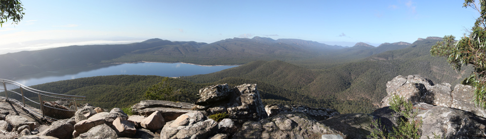
Sundial Peak
Departing from the Sundial Carpark, this 4.2 km return walk, which takes between 90 minutes and two hours, offers dramatic, panoramic views over Lake Bellfield (the photo at the top of this entry was taken from the lookout). Walkers who want to, can continue down the escarpment and reach the shores of Lake Bellfield.
Sundial Carpark to the Pinnacle
This medium difficulty 4.2 km walk from the Carpark takes 90 minutes to two hours, rises and falls 110 metres, is recognised as the easiest access to the Pinnacle Lookout with offers impressive, panoramic views over Lake Bellfield.
Lakeview Loop
The easiest access to a lookout over Lake Bellfield, the Lakeview Loop is a 1.8 km circuit from the Sundial Carpark. It is particularly impressive in the spring months when the area is covered in wildflowers.
(c) Mount Rosea
Further along Silverband Road is the Rosea Carpark which is situated in a forested area at the foot of Mount Rosea. There is an 8.6 km return Mt Rosea Loop Track which is rated medium-hard and takes between 4-6 hours. It leads up the 'Grand Stairway' and past Eagle Rock to the Gate of the East Wind and the summit of Mount Rosea which offers dramatic views across the timbered mountains and valleys.
(d) Silverband Falls
Silverband Road heads down the hill and eventually joins the Grampians Tourist Road at the shore of Lake Bellfield. About 3.5 km Beyond the Mount Rosea Carpark is the Silverband Carpark. There is a 1.4 km, 30-40 minute, return walk through a fern forest to the Silverband Falls.
Other Attractions in the Area
4. Aboriginal Rock Art
One of the most significant claims to importance of the entire region is that it contains about 80% of all Aboriginal Rock Art found in Victoria and that, not surprisingly, it has the best collections of rock art in south-western Victoria. There is an excellent, downloadable brochure titled Aboriginal Rock Art Sites at http://www.brambuk.com.au/assets/pdf/grampiansnationalparkrockartshelters.pdf. It deals with the Northern Gariwerd-Grampians National Park and the Southern Gariwerd-Grampians National Park complete with detailed maps of the locations and descriptions of what can be seen.
Northern Gariwerd-Grampians National Park
"These sites are at the northern tip of Gariwerd, about an hour’s drive from Budja Budja (Halls Gap). Gulgurn Manja (Flat Rock) is located 5 km south of the Western Highway near the Hollow Mountain camping ground. There is a 15-minute gentle walk to the site from Flat Rock Road. Access to Ngamadjidj (Cave of Ghosts) is via Plantation Road. There is a 100-metre easy walk to this small rockshelter from the carpark." The Gulgurn Manja, which means 'hands of young people', is a rock shelter which includes paintings of emu tracks, hand prints and bar lines. The Ngamadjidj, which is located in a cave near a waterhole is unusual because the painted figures all all painted in white clay. The age of the art is unknown.
Southern Gariwerd-Grampians National Park
"These sites are about a 1-hour drive from Halls Gap, along the Glenelg River Road, Lodge Road and Red Rock Road. Billimina is a 15-minute, steady uphill walk from Buandik picnic and camping area. Manja is a further 10-minute drive from the Buandik camping area. There is a 20-minute uphill walk to the impressive sandstone outcrop from the carpark beside the Billywing Pine Plantation." The Billimina shelter art is characterised by many bars arranged in horizontal rows. There is also images of emus, kangaroo and emu tracks and 55 human stick figures. At Manja there are fine examples of hand stencils as well as some images of animal tracks and human stick figures.
Central Grampians
The best way to access the Central Grampians is to follow Mount Victory Road from Halls Gap and continue to the north-west and Horsham. Nine km from Halls Gap the Glenelg River Road leads by the large Boreang Campground where there is a short and easy 600 m return walk to Paddy's Castle, a rock formation beside the river.
Further along Mount Victory Road is Mount Difficult Road which leads to a car park from which there is a short walk to the Boroka Lookout which offers panoramic views over Halls Gap and the Fyans Valley.
Further along Mount Victory Road and turn right is a car park which has a short walk to Reed Lookout which has excellent views of the Victoria Valley and across to Lake Wartook. The carpark is also the starting point for a 2 km return walk to the geographic formation known as the Balconies.
The next road to the right off Mount Victory Road leads to Lake Wartook, where there is fishing and a picnic area, and a left leads to the MacKenzie Falls carpark, kiosk, information board and picnic area. Two tracks provide views of MacKenzie Falls. One of the state's most spectacular waterfalls.
Further along Mount Victory Road is Zumstein Picnic Area, originally a tourist park established by Walter Zumstein in 1923. There are usually large numbers of benign kangaroos in the picnic area as well as red deer, birds, native flowers and ferns.
History
* Prior to the arrival of Europeans the Jardwadjali and Djab Wurrung Aborigines had lived in the area for at least 5000 years.
* The first Europeans to explore the area were Thomas Mitchell and his party who travelled through the area in 1836.
* Edward Eyre and Robert Briggs followed in Mitchell's footsteps in the late 1830s.
* The first settler was Charles Browning Hall who reached the area in 1841.
* Hall also explored Roses Gap which was named after Philip Rose who took over Hall's run in 1842.
* Settlers moved into the district 1860s with the discovery of gold at Stawell.
* In 1862 land was rented from the owner of the local pastoral run.
* The commencement of saw-milling and the opening of the Heatherlie Quarry occurred in the early 1870s.
* A timber and bark hut known as Delley's Inn was established in 1870.
* In 1875 John D'Alton, the Stawell borough engineer, devised a system to bring water from the Grampians via a tunnel cut through the Mt Williams range. He built a weir on Fyans Creek.
* Halls Gap's first store was built nearby in 1876.
* D'Alton's family selected land in Fyans valley in 1878.
* The weir, dam and tunnel were completed in 1881. They brought workers to the area and a small township developed at Borough Huts.
* A tramline to Stawell was established in 1881-82 and Grampians sandstone was used in Stawell for the courthouse and St Patrick's Church and, in Melbourne, for the new Government House, the Melbourne Town Hall, the law courts, the public library, the museum and a number of banks and churches.
* Lake Wartook was built in 1886.
* In 1887 alluvial gold was found in Stony Creek. Despite the appearance of 300 prospectors, little gold was discovered.
* A school was opened in 1890.
* Holiday homes and a mill along with the workers' cottages were all built in the 1890s.
* In 1890 the growing tourist trade resulted in the creation of a recreational camping reserve.
* Halls Gap Post Office was opened in 1893.
* Halls Gap Public Hall was built in 1899.
* Lake Lonsdale was completed in 1903.
* The Grampians were declared a reserved forest in 1907.
* The Mafeking goldrush occurred at Mount William between 1900 and 1912.
* In 1923 naturalist and beekeeper Walter Zumstein opened a tourist park. That year the Mount Victory Rd from Halls Gap to Zumstein's was opened.
* School lessons commenced in 1921.
* The Bellfield Hotel opened in 1924. It had 60 rooms, a tennis court and golf course.
* A school building was erected in 1928.
* In 1969 Lake Bellfield started filling up.
* In 1990 the Brambuk Cultural Centre opened.
* In 1992 the Grampians Grape Escape festival was launched.
* In 2010 and 2011 the town was threatened by floods.
* The Halls Gap Tourist Hub was opened in 2014
* By 2018 more than 10,000 people were visiting the area every school holiday.
^ TOPVisitor Information
Halls Gap Visitor Information Centre, 117-119 Grampians Road, Halls Gap, tel: (03) 5361 4444, 1800 065 599. Open 9.00 am - 5.00 pm, seven days a week.
Brambuk the National Park & Cultural Centre, 277 Grampians Road, tel: (03) 5361 4000, seven days a week.