Small rural service town in Victoria's Mallee region
Hopetoun is a small rural service centre in the southern Mallee. Surrounded by rolling sand hills and grassy plains, the town is located on Yarriambiac Creek, near Lake Coorong, in a district known for its grain production, prime lambs, gypsum, Angora goats, poultry and pigs. It is a quiet town driven by the surrounding rural economy.
Location
Hopetoun is located on the Henty Highway, 385 km north-west of Melbourne and 63 km north of Warracknabeal.
^ TOPOrigin of Name
It was Edward Lascelles, the 'Father of the Mallee', who named his house, and subsequently the town, Hopetoun. It was the name of the seventh Earl of Hopetoun, Lord Hopetoun, who was Victorian Governor from 1889-1895 and the first Governor-General of Australia (1901-1903). He was a friend of Lascelles and a regular visitor to the house.
^ TOPThings to See and Do
Walks Around Hopetoun
There is a very useful brochure - Hopetoun Walk & Drive Town Discovery Tours - available at Gateway Beet in the main street which outlines five walks and a drive around the town.
Walk 1 - is literally a walk up and down the main street of town. To indicate how small Hopetoun is - it takes ten minutes.
Walk 2 - this is the sensible, all encompassing walk around the town and takes around 90 minutes. It goes down to Lake Lascelles and comes back up to town via the Corrong Homestead, the Hopetoun Historical Society Park and Hopetoun House.
Walk 3 - this could be called the "church walk" as it passes the Uniting Church, Church of England, Baptist and Catholic churches and the local Masonic Hall. It takes around 30 minutes.
Walk 4 - a pleasant 45 minute walk down the main street, around the old racecourse and back to the fountain.
Walk 5 - a 45 minute walk from the local fountain down to the grain silos and past the old railway station.
There is also a "quiet drive" around the town which covers most of the attractions which can be seen by walking.
Corrong Station Homestead and McGinnis Park
This simple log homestead, constructed from local pine and now covered with corrugated iron, was built around 1846 Peter McGinnis, for his wife, his seven children and their adopted Aboriginal boy, Jowley, known as Black Peter, who is buried in the local cemetery. McGinnis was the first European to be granted land in the area. The house is located in McGinnis Park off Evelyn Street amongst a lot of Australian native plants, displays of historic farm machinery and a well preserved local lockup which was still being used as recently as 1975. The lockup was donated to the park by the Victorian Police. It is generally open weekends but on an informal basis. The park can be entered without a key but people wanting to inspect the Corrong Station Homestead should contact Ron Wiseman (03) 5083 3240, Clive Wooding (03) 5083 3532 or Jean Webster (03) 5083 3362.
Hopetoun House
Located at 77 Evelyn St, and now a private home, is Hopetoun House built of local limestone in 1891 by Edward Lascelles who was largely responsible for transforming the scrub of the Mallee into productive agricultural and pastoral land. The house was named after the seventh Earl of Hopetoun who was Victorian Governor from 1889-1895 and the first Governor-General of Australia (1901-1903). He was a friend of Lascelles and a regular visitor to the house. The town developed around Hopetoun House and later took its name.
The brick-and-stone home has formal gardens and a circular drive. One of the highlights, which says worlds about the area, is the huge dance floor which is underneath the house. It was so hot in summer (in 2007 Hopetoun was known as the hottest town in Victoria) that the dance floor was kept cool by being located downstairs. The house originally had uninterrupted views of the lakes.
Lascelles, sometimes referred to as the "Father of the Mallee", is one of those forgotten figures who loom large in the history of rural Australia. Here’s an abridged version of his entry in the Australian Dictionary of Biography.
“He was born on 3 October 1847 in Bothwell, Van Diemen's Land, son of Edwin Lascelles and his wife Eliza. Lascelles became an expert wool-classer and broker, and as the chief wool-valuer and manager he … experimented in wool production at Ingleby, a lease near Winchelsea, and substantially improved both quality and clip.
In the 1870s Lascelles became interested in the Mallee area of north-western Victoria. In December 1876 he took over the Lake Corrong sheep station on Yarriambiac Creek. In 1883 he became sole lessee under the provisions of the Mallee Pastoral Leases Act. By then the property included the Minapre and Wilhelmina runs, and he took over the Tyrrell Downs run on the eastern side of Lake Tyrrell. For some time he also leased 106 sq. miles (27,500 ha) in the far western Mallee, planning experiments in reclamation and farming methods under desert conditions, but had to abandon the run after parliamentary opposition on the ground that his holdings were already adequate.
"On all his Mallee properties Lascelles faced the great problem of vermin eradication and succeeded with rabbit-proof fencing, methods of poisoning and clearing. In the late 1880s he began to plan the subdivision of Lake Corrong run into 480-acre (194 ha) allotments for wheat growing. The surveyor, George Murdoch, also drew up plans for the new service centre of Hopetoun. E. H. Lascelles & Co. was formed and subdivision began in 1891 when the first sale of farm allotments and township blocks was held. An irrigation and town water supply was set up largely financed by Lascelles. Nearby an experimental farm was laid out with lucerne and wheat paddocks, a large orchard and a vegetable garden. The farm became a show place and Lascelles revelled in this proof of the district's prospects. After overcoming government opposition he began to build the Beulah-Hopetoun railway in 1893 but in the financial crisis the line was completed by the government.
"Lascelles was the first to introduce into Victoria the system of share-farming whereby the tenant delivered a third of his harvest to the company, but when yields were very low the company did not take its share. In the early 1890s the Hopetoun settlement grew, attracting settlers from South Australia and Britain as well as Victoria. Lascelles was the first president of Karkarooc Shire in 1896-97, and as managing director of the Mallee Agricultural and Pastoral Co. Ltd opened up the Tyrrell Downs property on the Hopetoun model. Unfortunately the start of the venture coincided with severe drought in 1895-1902. The Hopetoun settlement was sufficiently established to survive, but the company ran into debt. However, a larger percentage of Lascelles's settlers survived than those on government subdivisions, and he encouraged them to remain on their holdings by extending credit with the local store-keepers, writing off debts and issuing a meat ration at weekly 'killing days'. Although the company's mallee settlements were not a financial success, many wheat farmers were firmly established and the mallee proved itself as an excellent wheat-growing region.” Lascelles left Hopetoun House and returned to Geelong in 1898.
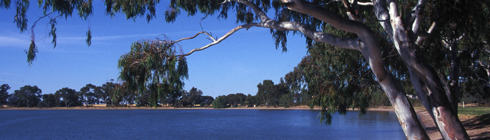
Lake Lascelles
Lake Lascelles is an attractive recreation spot located only 400 metres from the shopping centre. The foreshore park has picnic facilities and barbecues and the lake is ideal for all water sports. There is a children's playground, a boat ramp and water sports facilities. The lawns at the edge of the lake are well kept.
Historic Mural and Memorial Fountain
A huge and colourful wall mural (20.7 x 3.7 metres) in the centre of town depicts aspects of local history (a stump-jump plough, wool bales, drovers, the Mallee roller etc) and local birds and wildflowers. It was painted by local artists Shirley Decker and Trish Hogan. The memorial fountain in the town centre was erected in 1929 as a tribute to Lascelles.
Other Attractions in the Area
Lake Corrong
Located just 1.3 km south-east of Hopetoun, Lake Corrong only fills up in very wet years. Consequently it has interest for visitors who want to explore the local birdlife and is suitable, when it has water, for canoeing, windsurfing or picnicking. It is also popular for fishing and yabbying. It was once a meeting place for Aborigines whose stone axes, grinders, mussel shells and ochre have been found around the lake's shoreline.
Wyperfeld National Park
Wyperfeld National Park, which currently covers 357,017 ha, is one of Victoria's largest national parks. It covers three distinct landscapes - the Big Desert country which lies in the west of the park; the Mallee which lies to the east; and the sand dunes and floodplains which lie to the north. It was a shallow sea 25 million years ago. The park contains a series of lakes which are linked by Outlet Creek, though they are usually dry, filling only when the Wimmera River floods, which is about once every twenty years. It fills Lake Albacutya which overflows into Outlet Creek. European settlers moved into the area in 1847. The first reserve was established in 1909 and as a result of lobbying by naturalists the park was declared in 1921. The park is known for its fauna and flora. It is home to kangaroos, emus and birds which survive in the semi-arid landscapes of sand dunes and spinifex, mallee scrub, heathlands and native pine woodlands of river red gum and blackbox. To access the park from Hopetoun, head west of the Hopetoun-Yaapeet Road. After 31 km the road veers to the right near Lake Albacutya and veers north for another 20 km to Wonga Camping Area where there are camping and picnic facilities, fireplaces, toilets, a visitors' centre, three self-guided interpretative walks and access to the James Barrett Nature Drive. Those entering the park in 4WD vehicles can gain access to Milmed Rock, Chinamans Well and North Callitris Track. There is also the acclaimed Mallee Drive - check out http://www.fwdvictoria.org.au/iconic4wd/mallee.html which has a downloadable map, track notes and information about the track conditions. The Mallee Drive from Hopetoun to Underbool is 126 km.
Eastern Lookout Nature Tour
There is a detailed, downloadable brochure - check out http://parkweb.vic.gov.au/__data/assets/pdf_file/0007/315826/Park-note-Wyperfeld-NP-Eastern-Lookout-Nature-Walk.pdf - which provides information on the 15-km Eastern Lookout Nature Drive which is suitable for 2WD vehicles. It includes details of the 25 minute return Eastern Lookout Walk which offers views over stands of Black Box, Red Gum, Native cypress-pine woodland and Mallee woodland. The walk also passes through country occupied by Wedge-tailed eagles, black-shouldered kites and nankeen kestrels. The rest of the drive travels through stands of Red River Gums; travels beside Lake Brimin which has not held water since 1921; passes through stands of Porcupine Grass and Mallee eucalypts; and, inevitably, traverses countryside that is called home by kangaroos and emus. It is an ideal opportunity for those interested in fauna and flora to study the uniqueness of the Mallee. The brochure explains the special importance of the plants and animals. For further information there is a useful and downloadable brochure. Check out http://parkweb.vic.gov.au/__data/assets/pdf_file/0006/315825/Park-note-Wyperfeld-National-Park.pdf.
Wathe Flora and Fauna Reserve
The Wathe Flora and Fauna Reserve is an important breeding ground for the Mallee fowl which is indigenous to this semi-arid region. The Mallee fowl can be detected by its distinctive mounds which are circular and dome-like in shape. They can be as much as five metres across and one metre high. The fowl lays its eggs inside this mound. Wildflowers bloom all year round. The reserve, which is largely on sand, is restricted to 4WD vehicles. It is signposted off the road from Hopetoun to Patchewollock.
History
* Prior to European settlement the area around Hopetoun was occupied by the Yarrikaluk people. The Wotjobaluk and Wergaia people were also in the area.
* The first European to settle in the area was Peter McGinnis who, in 1846, was granted a sheep run which he named 'Lake Corrong'.
* In 1878 McGinnis sold his property to Edward Lascelles, known as the 'Father of the Mallee' who, more than anyone else, was responsible for the European settlement of the district.
* By the 1860s Lascelles was fighting a rabbit infestation which had significantly reduced wool production. A rabbit-proof fence was eventually built along the 36th parallel to prevent rabbits moving into the Wimmera region.
* To the west of Hopetoun Lascelles developed a six-acre experimental orchard named the Lochs in the 1880s.
* The town developed around, and drew its name from, Hopetoun House which was built in 1891.
* The first township blocks were sold in 1891. The town's post office opened that year.
* Lascelles successfully lobbied the government to extend the railway to Hopetoun in 1893.
* Water was channelled from the Grampians to the new settlement in 1899.
* By 1907 water was being reticulated to the town through open channels.
* After the First World War, many soldier settlers were granted farm plots in the district.
* In 2009 the town recorded a temperature of 48.8°C - the highest temperature ever recorded in Victoria.
^ TOPVisitor Information
Hopetoun and District Neighbourhood House, 75 Lascelles St, tel: (03) 5083 3001.
^ TOPUseful Websites
There is a useful local website: http://www.yarriambiack.vic.gov.au/tourism/hopetoun and a basic local website http://www.hopetounvictoria.com.au.
^ TOP
Is there more info on Jowley and Aboriginal interaction with whites?
Were there Aboriginal tribes in The Hopetoun area?
Yes….formal accounts of Jowley, also known as Black Peter, essentially adopted by the McGinnis family. my great-grandparents came from Ireland 1854, came to the McGinnis station as shepherds, and their children grew up with Jowley. My great-great-grandparents’s moved from McGinnis station to the Wimmera and were able to access government opening up/.
grazing blocks. MCGinnis family, Scotch background, Catholic in practice, as my great-great-grandparents’s and Jowley also involved. His mother lived south of Hopetoun.
A fascinating local history around the Coorong …tribal group Wotjabulak, carrying its own difficulties with at times, hard country . It is great to see that the descendants of this particular indigenous group are respected and recognised in today’s times, tho ‘ I am not very accurate in giving a written description. However, the indigenous peoples of the region were well respected by English experts, today called scientists, in their visits and assessments of the Coorong realities. I haven’t written this too accurately. I’m supposed to be cooking tea!!, Anyone who reads this …you’re welcome to respond.
Looking at buying a renovator, needs to be cheap
Just out of interest, there is nothing on the town of Woomelang, just 20 mins down the road, in between Hopetoun and Sea lake
Comedy festival show is on the 21st June 2024. Check out Woomelang bush nursing center on Facebook