Major tourist destination and Australia's third-largest island
Kangaroo Island is one of the nation's supreme scenic spots. It is a true sleight of hand which often leaves visitors bemused because it is much larger than they think - it is 132 km by road from Penneshaw in the east to Cape Borda in the west - and while the scenic locations are spectacular, much of the island is unremarkable, low scrubby bushland. Isolation, the poor quality of the soils, the scrubby nature of the vegetation, an average annual rainfall of 491 mm leading to marginal water supplies, all conspired to ensure that Kangaroo Island remained relatively underdeveloped. Today the island has a population of less that 5,000 and its economy is primarily driven by tourism. It is recognised as Australia's third largest island (after Tasmania and Melville Island) with 509 km of coastline and stretching 155 km from east to west, 55 km at its widest point, and there are nearly 1600 km of sealed and unsealed roads. Some of the island's most beautiful destinations are accessible over rather dubious roads. Oh, yes, and there are kangaroos on the island but they don't advertise themselves.
Location
Kangaroo Island is south-west of Adelaide and across the Backstairs Passage from Cape Jervis. Cape Jervis is located 107 km south of Adelaide and the Kangaroo Island town of Penneshaw is easily accessible by ferry which crosses the 16 km from Cape Jervis to Penneshaw. There are also regular flights from Adelaide to Kingscote.
^ TOPOrigin of Name
Kangaroo Island was named by Matthew Flinders in 1802 after he and his crew had killed 31 kangaroos on the island. Flinders wrote in his journal: "half a hundredweight of heads, forequarters and tails were stewed into soup ... and as much steaks given ... to both officers and men as they could consume by day and by night ... In gratitude for so seasonable a supply, I named this southern land Kangaroo Island." Flinders also named the narrow strait between the island and the mainland. In his journal he wrote: "It forms a private entrance, as it were, to the two gulphs; and I named it Backstairs Passage".
^ TOPThings to See and Do
How to Get There
There is a car/passenger ferry run by Kangaroo Island SeaLink which leaves Cape Jervis for Penneshaw four times daily. There are extra services during peak times. It takes about 45 minutes to make the 16 km journey. Reservations and times: (08) 8553 1185 or 1800 811 080 or https://www.sealink.com.au. Both Rex Express Airlines and QantasLink offer flights from Adelaide Airport. Check out http://www.rex.com.au (tel: 13 17 13) or http://www.qantas.com (tel: 13 13 13).
1. The Main Towns
(a) Kingscote
Although it has a population of less than 2000, Kingscote is recognised as the adminstrative centre of the island. It is located on the north coast and looks across the Bay of Shoals. The settlement was established by the South Australian Company in 1836 and as such it can claim that it was the first town in South Australia. It was named after Henry Kingscote, a director of the South Australian Company and, for the first six months of its existence, it was seriously touted as a possible capital for the state. A lack of good, reliable water saw it quickly lose favour. For the brief time it prospered it was an important port and it provided basalt for the road which was built between Port Adelaide and the emerging town of Adelaide.
There are a number of interesting buildings and locations in the town including:
The Old Mulberry Tree
This historic mulberry tree, near the shoreline and off Governor Wallen Drive, was planted by some of the island's earliest settlers. No one knows for sure who planted it and a sign indicates that there are no fewer than four families - the Powells, Christians, Kleemans and Baeres - who all believe that their forebears planted the tree. The argument is that each of the four families had an ancestor who planted a mulberry tree at Kingscote. No one is quite sure which of the forebears planted this particular tree although the Kleeman family, which had grown to 2,562 members of an extended family by 1969, claim that the original Friedrich Wilhelm Kleeman planted the tree in 1837.
Hope Cottage Museum
Located at 22 Centenary Road is the Hope Cottage Museum. It is part of a trio of cottages originally called Faith, Hope and Charity (Faith is no longer in existence) which were built in the late 1850s by Charles and Michael Calnan. It is open daily from 1.00 pm - 4.00 pm, tel: (08) 8553 2656. The website notes: "As well as the historic cottage set out to represent 1860s life, the site contains a complex of other buildings displaying farm machinery, domestic and communication equipment, sea and air travel (including items from the SS Karatta which brought visitors and goods to the island for over 50 years in the 20th century), plus a shearing shed, blacksmith’s shop, 1950s’ garage, the complete Masonic Lodge Room from The Island Lodge No 54 and the original lantern room from Cape Willoughby, South Australia’s first lighthouse." The National Trust website provides comprehensive information - check out https://www.nationaltrust.org.au/places/hope-cottage.
(b) American River
This small settlement was named by the American sealers who settled there for four months in 1803. There is a memorial plaque commemorating their brief stay. By the late 19th century the sealers had long departed and the small town became the first tourist destination on Kangaroo Island. Today it has become a place for retirees as well as holidaymakers who enjoy the fishing, swimming, boating and sailing which the area offers.
(c) Penneshaw
Penneshaw is a small township on Backstairs Passage which, in recent times, has become the major entry point to the island with the establishment of the car/passenger ferry from Cape Jervis. Both Matthew Flinders and Nicholas Baudin moored at Christmas Cove and Frenchman's Rock respectively. Baudin scratched an inscription on Frenchman's Rock (translated it reads "Expedition of discovery by Captain Baudin in the Geographe. 1803"). The original Frenchman's Rock is now housed at the Gateway Visitor Information Centre, Howard Drive, Penneshaw. A replica is located on Penneshaw Beach. The main attractions in the town include:
Penneshaw Maritime and Folk Museum
Located on Howard Drive in the old Hog Bay School, which dates from 1869, the Maritime and Folk Museum is open from 3.00 pm - 5.00 pm Wednesday to Sunday. The National Trust website explains: "The museum comprises three separate rooms, each dedicated to a specific historic theme. The School Room showcases photographs and objects that reflect a bygone era in education within this remote, rural community. In the Maritime Room the history of both the sealing and whaling industry, and commercial shipping activities, are depicted by models, images, and artefacts. The McKenzie Room conveys to the visitor a sense of island life; highlighting the isolation experienced by earlier settlers, and celebrating the pioneering spirit that has been integral to the development and identity of the local community. Outside the museum, in the courtyard, a lifeboat from the S.S Karatta is further testimony to the community’s close association with the sea, and a grinding mill used to crush stone for the production of china is evidence of early industry on the island." For more information tel: (08) 8553 1109 or check out https://www.nationaltrust.org.au/places/penneshaw-maritime-and-folk-museum.
Penneshaw Penguin Centre
Located on Bay Terrace (close to the Ferry Terminal), the Penneshaw Penguin Centre organises tours which vary throughout the year. The tours, led by experienced guides, visit a small colony of around 15 breeding pairs of Little Penguins, also known as Blue Penguins and Fairy Penguins. Bookings are essential as the groups are limited in size. The centre provides details on the 18 species of penguins and has an impressive art display as the previous manager of the centre is Nicholas Burness Pike, an award winning wildlife artist. It is possible to purchase his work. The current manager is Alana Whennen. Check out the website - https://penneshawpenguincentre.com - for details and information about booking tours.
2. The Main Attractions on the Island
Seal Bay Conservation Park
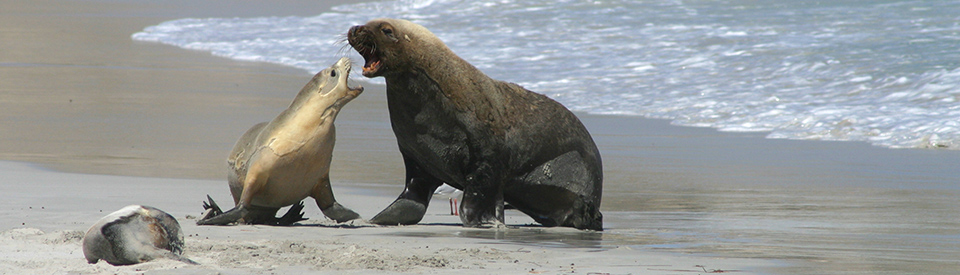
Seal Bay Conservation Park, located 96 km south-west of Penneshaw via Cygnet River, is a substantial area of 750 ha which includes both the Seal Bay area (a carefully managed section of coastline where, under supervision, people can see seals lying on the beach) and the Little Sahara sand dunes which lie between Seal Bay and Vivonne Bay. The main attraction is the seals which have their home on the beach at Seal Bay. Tours, which last 45 minutes, and are restricted to 25 people, go regularly throughout the day - the first is at 9.00 am and the last at 4.00 pm - and are led by experienced guides who talk about the Australian sea lion. The excellent website explains: "There is nowhere else in the world where you can listen to an expert give you their unique insight into how these endangered animals hunt, surf, rest, interact with their pups and defend their territory ... You’ll follow a boardwalk through the dune system to the beach, and on the way you’ll have breathtaking views of the colony and the majestic coastline. Sometimes you’ll pass sea lions snoozing in the dune system, or even lying in the middle of the beach path. Our guides have made studying the magnificent Australian sea lion their life’s work. A guided beach tour does not follow a standardised script. Instead your guide will be interpreting sea lion behaviour and what’s happening in the colony – at that very moment. They’ll make sure everyone is safe and keep you at an appropriate distance (no closer than 10 metres), making sure the sea lions do not feel threatened by human presence." There are times when Seal Bay has a seal population of over 1,000 sea lions. For details contact (08) 8559 4207. For more information check out https://www.sealbay.sa.gov.au/home.
Little Sahara
Located between Seal Bay and Vivonne Bay, and hidden from the road, it is best to either ask for directions at the General Store at Vivonne Bay or, if you are going to go sand boarding, to hire a board from Kangaroo Island Outdoor Action (see http://www.kioutdooraction.com.au) who will provide detailed directions. There is a rough unsealed track to a car park and beyond it the sand dunes, swept up by the winds off the Southern Ocean, rise impressively. For those eager for an adrenalin rush, to sand board down the dunes can be a highlight of a trip to the island.
Vivonne Bay
Located 101 km from Penneshaw, Vivonne Bay (named by Nicholas Baudin) is recognised as one of the most beautiful beaches in Australia. It is perfectly white although at times there can be considerable seaweed along the shoreline. The facilities are minimal. There is a General Store, a jetty, some holiday cottage accommodation, a couple of car parks and a lookout near the jetty. The appeal of the area lies in the views across the bay and the sands on the beach which are idyllic and pristine. Nearby is the Vivonne Bay Wildlife Reserve which is a private park with 40 km of walking trails. The sands at the eastern end of the beach have been blown into vast dunes which have been named Little Sahara.
Kelly Hills Conservation Park
Located 90 km south-west of Kingscote, the Kelly Hills Conservation Park is a 6,306 ha park located between Seal Bay and Flinders Chase National Park on the southern coast of Kangaroo Island. The area was named after a horse, Ned Kelly, which fell into the caves. The landscape is dominated by mallee, coastal scrub and there are stands of old growth forest. There are a number of walking trails including the Burgess Hike, a short 1.2 km, 30 minute walk from Kelly Hill Caves through a Sugar Gum forest, and an 18 km walk to Hanson Bay from Kelly Hill Visitor Centre which "passes through banksia heath, pink gum woodlands, mallee and coastal heath, alongside freshwater lagoons, and over dunes to viewpoints that provide wonderful vistas inland and along the coast".
The highlight of the park is the Kelly Hill Caves which has a "Show Cave Tour" which lasts about 40 minutes and which runs seven times a day between September and April, starting at 10.30 am and with a last tour at 4.00 pm. It has more restricted times during the winter months. There is also a 2 hour adventure caving activity which can be booked. The details are listed on the PDF.
For greater detail check out https://www.parks.sa.gov.au/find-a-park/Browse_by_region/kangaroo-island/kelly-hill-conservation-park or tel: (08) 8553 4464. There is also a useful and downloadable PDF which can be accessed from the Park home page.
Flinders Chase National Park
Flinders Chase National Park, which covers most of the western half of Kangaroo Island, is one of the largest national parks in South Australia. It includes such highlights as Admirals Arch, the Remarkable Rocks, the Casuarina Islets, and the Cape Borda and Cape du Couedic lighthouses. It is an ideal place to see sea lions, sea eagles, ospreys, Cape Barren geese, kangaroos, wallabies and black cockatoos. Check out https://www.parks.sa.gov.au/find-a-park/Browse_by_region/kangaroo-island/flinders-chase-national-park for greater detail.
(a) Casuarina Islets
Located just south of Cape du Couedic and 96 km from Kingscote, the Casuarina Islets are two small islands (they both cover about 2 ha) which were formed between 7,500 and 9,000 years ago. The North Island is 29 metres above sea level at its highest point and the South Island is 35 metres. The islands are known for their breeding colonies of New Zealand fur seals, silver gulls, Pacific gulls and crested terns. They are also home to Australian sea lions. The colonies can be viewed with binoculars from the mainland. They are both protected wildlife sanctuaries.
(b) Admirals Arch
Located at Cape du Couedic, Admirals Arch is a natural rock arch which is a superb example of the unrelenting power of the winds and the Great Southern Ocean. One of the highlights of the area are the long-nosed fur seals which can be seen lying on the rocks below the headland.
Cape Borda Lighthouse
When the French sailor Nicholas Baudin first sighted the rugged cliffs of Cape Borda he named them after the French mathematician, Jean Charles de Borda. The Cape Borda lighthouse was built in 1858 on a cliff 154 metres above the sea. It has a range of 21 nautical miles. The actual lighthouse was 10 metres above the ground and, rather extraordinarily, it is the only square stone lighthouse in South Australia. A rather dubious claim to fame.
In the early days there was a cannon which was sometimes used to warn ships of the danger they were in, particularly if it was foggy and they had very low visibility. The cannon is now fired daily. The Lighthouses of Australia website notes: "In late 1999, NPWSA restored the cannon and test-fired it at Midnight 2000 as part of a global exercise of time-signals at maritime locations around the world. The cannon was found to be Y2K compliant and has since fired every day at the traditional hour of 1.00 pm." The lighthouse was converted to automatic operation in 1989. For most of its working life the lighthouse was so isolated that there is a small graveyard nearby where 13 people are buried. Of particular interest is the Cape Borda Maritime Museum which provides a detailed history of this lonely outpost. For more detailed information check out https://lighthouses.org.au/sa/cape-borda-lighthouse. It is possible to stay in the Lighthouse Keeper's cottage. Check out https://www.parks.sa.gov.au/find-a-park/Browse_by_region/kangaroo-island/cape-borda-lightstation for booking arrangements.
Remarkable Rocks
Located 155 km west of Penneshaw, the Remarkable Rocks, an extraordinary and impressive natural phenomenon, have been formed by erosion over the past 200 million years. The rock itself was created by an upheaval of molten rock more than 500 million years ago. They are the product of the erosion of a huge granite dome by the combined forces of sea spray, wave action (when the sea level was much higher), heating and cooling, wind and salt. To geologists they are known as domed inselbergs (the same term is used for Uluru). Although at the other end of the island from Penneshaw and Kingscote, they are worth the effort. A unique geological formation.
Cape du Couedic Lighthouse and Heritage Accommodation
Located 154 km west of Penneshaw, the Cape du Couedic Lighthouse (which now offers Heritage Accommodation - check out https://www.sealink.com.au/adelaide--ki-accommodation/165-Lighthouse-Keeper's-Cottages---Cape-du-Couedic) was built as a result of three shipwrecks occurring in the years prior to construction. The excellent Lighthouses of Australia website (https://lighthouses.org.au/sa/cape-du-couedic-lighthouse) records that "The Cape du Couedic Lighthouse was constructed between 1906-1909 and was the fifteenth to be built on South Australia’s coast. It was also the last light to be built in South Australia before the Commonwealth Government took over the management and control of Australian lighthouses in 1915. The actual transfer did not occur until 1917. The tower itself was built from 2,000 pieces of local stone. Three four roomed cottages were also built of local stone with slate roofs for the headkeeper and two assistants ... The Cape du Couedic lighthouse reserve, with the exception of the lighthouse, a storage shed and the small area on which these structures were located, was sold to the Flora and Fauna Board of South Australia in 1959. The site now forms an integral part of Flinders Chase National Park. A feature of the area is Admirals Arch at the end of the point that the lightstation is on. The area is also home to a colony of New Zealand fur seals. Another more extraordinary feature 4 km east of Cape du Couedic are the Remarkable Rocks."
Cape Willoughby and Cape Willoughby Lighthouse
Cape Willoughby is Kangaroo Island's easternmost point and it is also the location of the island's first lighthouse. The cape was named in 1802 by Matthew Flinders. It was named after the town of Willoughby in Lincolnshire, England. The lighthouse was built in 1852 and was initially named Sturt Lighthouse after the explorer, Charles Sturt. It was constructed from granite and limestone which was quarried from a nearby cliff and it was designed to assist shipping through the Backstairs Passage. There is detailed information on the lighthouse at the excellent Lighthouses of Australia website. Check out https://lighthouses.org.au/sa/cape-willoughby-lighthouse. The keeper's cottages are available for holiday rental. Check out https://www.sealink.com.au/adelaide--ki-accommodation/159-Lighthouse-Keeper's-Cottages---Cape-Willoughby.
Stokes Bay
Located 44 km west of Kingscote on the north coast of Kangaroos Island, Stokes Bay has one hugely appealing quality: it is accessed by a secret, natural rock tunnel. The visitor enters and comes out on an excellent natural pool and a good beach for swimming and surfing. There is also opportunities to explore the rock pools and enjoy a "beach pool" which is protected by a low, rocky barrier. Beyond the beach the area is home to the Stokes Bay Bush Garden (see their Facebook page - https://www.facebook.com/StokesBayBushGarden/?hc_ref=SEARCH for details) - a three hectare garden with over 150 species which are native to Kangaroo Island - and the unusual Will's Rare Breeds Farm (see http://www.rarebreedsfarm.com.au for details and entry times) which has rare breeds of sheep, pigs, poultry and cattle.
Emu Bay
Located 16 km north-west of Kingscote, Emu Bay is known for its particularly beautiful 4 km long white beach which is ideal for walking and swimming. The location was once the main port on the island's north coast but now all that is left is a jetty which was built in 1916 to ship grain and timber. It is still used by fishermen. In spite of this charming sleepiness of the area it is recognised as the second largest holiday destination for families on the island. The 4 km beach is the only beach on the island which can be driven on by people who have 4WDs. It is also excellent for fishing and bird watching. For more suggestions check out https://www.weekendnotes.com/emu-bay.
Other Attractions in the Area
Kangaroo Island Shipwreck Trail
The Kangaroo Island Shipwreck Trail brochure can be downloaded at https://www.environment.sa.gov.au/our-places/Heritage/Visiting_heritage_places/Shipwreck_trails/Kangaroo_Island. It explores the history of seven of the total of more than 80 shipwrecks around the coastline of Kangaroo Island. The earliest, the William, was wrecked in 1847 and the most recent, the Portland Maru, sank off Cape Torrens in 1935. The Shipwreck Trail, which starts at both Kingscote and Penneshaw, tells the story of seven shipwrecks with detailed signage at Cape Willoughby (the Kona), Point Tinline (Osmani), Vivonne Bay (You Yangs), Cape du Couedic (Loch Sloy), Vennachar Point (Loch Vennachar), Cape Borda (Fides) and Cape Torrens (Portland Maru).
The sign at Cape Borda for the Fides records: "On its final voyage, the Fides departed London for Port Adelaide on 11 January 1860 with a general cargo valued at £22,000. In the early hours of 22 May, strong currents off Kangaroo Island's north coast swept the sailing vessel ashore at the base of what is now known as Fides Bluff, just west of Snug Cove. Heavy seas pounded the barque and within hours it had totally broken up. Five crew reached shore and, after an arduous trek along the cliffs and through dense scrub, the survivors arrive at the Cape Borda Light House." Then follows a letter which one of the survivors, the Third Mate, wrote to his parents in Finland. A number of these vessels can be explored by experienced scuba divers. For more information on the Heritage Trail and information about diving on the sites, contact the Heritage Branch of the South Australian Department of Environment & Heritage, (08) 8124 4944.
A Footnote on the Sealers on Kangaroo Island
From the earliest times, there were sealers on Kangaroo Island as the seas around the island were rich pickings. In 1819 when a Captain Sutherland explored the island, he could report that the sealers were "little better than pirates". He depicted them as people who "dress in kangaroo skins with linen, and wear sandals made of seal skins, they smell like foxes". Most of the sealers had arrived from Tasmania where they had, infamously, enslaved Aboriginal women and, apart from using them for sexual purposes, had also used them to capture and kill seals. The women were prized by the sealers because they were highly skilled hunters who could swim across to the seal colonies, move quietly amongst the seals and kill large numbers without panicking the colonies.
History
* The island was first settled by First Nations peoples but their history is scant and the official map of First Nations languages does not list a language group as living on the island.
* There is evidence that the First Nations peoples left the island about 3,000 years ago.
* The first European to sight the island was Matthew Flinders who, during his circumnavigation of Australia in the Investigator in 1802, explored, charted and named the island.
* In 1803 the island was visited both by the French navigator Nicholas Baudin and some American sealers who set up their operations on the site of American River.
* Captain Sutherland explored the island in 1819 to assess its suitability as a capital of the state of South Australia.
* The first official settlement of the island occurred in 1836 when the South Australia Land Co. established a base at Nepean Bay. This eventually grew into the island's main town, Kingscote.
* By 1837 shiploads of German emigrants were brought to the island by the South Australia Land Co. but the soil was infertile and the water supply was unreliable.
* By 1840 the German settlement had collapsed and most of the settlers had moved to the mainland.
* Salt was mined on the island in the 1840s.
* In 1852 the Cape Willoughby lighthouse on the Backstairs Passage was constructed.
* In 1858 the Cape Borda lighthouse was turned on.
* By the late 19th century eucalyptus oil production and gypsum mining were well established.
* By 1905 tourism had become important to the island's economy.
* The Flinders Chase National Park was established in 1919.
* The cottages at Cape du Couedic lighthouse were made available as holiday rentals in 1991.
* In 2020 38% of the island was burnt by bushfires.
* In 2023 Lonely Planet named the island the No.2 must visit region in the world.
* Today the island's numerous natural attractions, and its large pristine areas, are the centrepieces of an economy driven by tourism.
^ TOPVisitor Information
Kangaroo Island Gateway Visitor Information Centre, Howard Drive, Penneshaw, tel: 1800 811 080, open 9.00 am - 5.00 pm Monday to Friday, 10.00 am - 4.00 pm Saturday and Sunday.
^ TOPUseful Websites
The island's useful and detailed official website is https://www.tourkangarooisland.com.au.
^ TOP
Hi there,
Just wanted to give you some up to date information about the Penneshaw Penguin Centre:
1) Tour times vary throughout the year
2) Bookings are essential and can be made via our website http://www.penneshawpenguincentre.com
3) Alana Whennen is now the owner and manager of the business and Nick will occasionally fill in for tours as needed 🙂
4) We have approximately 15 breeding pairs
Thanks!
The bird and reptile shows at Raptor Domain are not to be missed.