Hugely significant ancient Aboriginal site
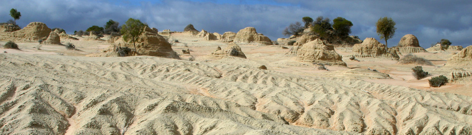
Mungo National Park is a 110,967 hectare archaeological and geomorphological site of international significance. Lake Mungo is the second largest in a system of nineteen dry lakes which were once part of Willandra Creek and is now part of the Willandra Lakes World Heritage Area which was declared in 1981. The dry lake is unforgettable. The stark, eerie, desert landscape; the vastness of the flat lake bed; the sparse vegetation and the unique crinkled and fluted dunes and ridges make the place look like a strange moonscape.
Lake Mungo is important for three reasons: It has "one of the longest continual records of Aboriginal life in Australia" having been occupied for over 50,000 years; the skeletons found in the sands of the lunette are the "oldest known fully modern humans outside Africa"; and the skeleton of Mungo Woman (or Mungo I as she is officially known), has been radiocarbon dated to around 40,000 years ago and "has provided the oldest evidence of ritual cremation in the world."
It is possible to go to Lake Mungo unaccompanied. It is equally possible, during school holidays, to take a guided tour with local Aboriginal rangers. There are a number of tours to the Lake. My personal favourite is Harry Nanya Tours, run by Graham Clark, a Barkindji man who knows the area and can provide genuine insights into the uniqueness of the lake, its history and its geomorphology.
Location
The entrance to Lake Mungo and Mungo National Park is located 1,024 km west of Sydney via the Hume and Sturt Highways; 707 km north of Melbourne; 167 km north-east of Mildura; 171 km north of Balranald; and 146 km east of Wentworth.
^ TOPOrigin of Name
Lake Mungo is named after the Mungo sheep station which was created in the 1920s when the land in the area was subdivided for soldier settlement. The property, owned by the Cameron Brothers, was named after a picture of St Mungo they had seen at St Mungo's Church in Scotland. St Mungo is the patron saint of Glasgow.
^ TOPThings to See and Do
Visiting the Park
Getting There
The park entrance can be accessed from Mildura, Balranald, Wentworth and Pooncarie. From Mildura take the road to Wentworth and past the Buronga limits turn rignt into Arumpo Road which is unsealed. From Balranald head north via Penarie and Bidura. There are two turnoffs to the park from the Wentworth-Pooncarie road - they are both south of Pooncarie. All roads have sections of gravel and can be closed when it is wet. The best time to visit is during autumn, winter and spring.
(a) The Visitor Centre and Meeting Place
This is the natural place to start any tour of Lake Mungo. It has a lot of information about the cultural heritage of the site; it has a meeting place outside with picnic tables and barbecues; and it has a large model of a diprotodon, a representative of the megafauna which once roamed the area. It is necessary, if you are self guided, to understand the archaeology and geomorphology of the lake. Otherwise the experience is reduced to walking over a lake and up the Walls of China - and that is a very small part of the entire experience. It is recommended that an hour should be spent before venturing out onto the dry lake bed.
(b) Aboriginal Discovery Tours
During the May and September school holidays Aboriginal rangers at Lake Mungo provide conducted tours. These tours usually involve the Foreshore Walk where the rangers not only recount the archaeology and the history but also introduce visitors to Aboriginal life in terms of fauna, flora and bush tucker. The tours can be booked on (03) 5021 8900.
(b) The Mungo Lookout
Located close to the Visitors Centre, the Mungo Lookout is an excellent overview of the entire lake. Although it is only 20 metres above the floor of the lake it offers a view which stretches 10 km across the lake and includes most of the lunette known as the Wall of China. It is a sensible point to get a perspective on the entire lake.
(c) The 70 km Mungo Track
For visitors wanting to explore the lake by themselves there is a 70 km self-drive tour which is an anti-clockwise loop around the lake starting at the Visitor Centre. It includes 15 stops each of which has detailed sign posted information. It takes you to the Mungo Woolshed, the Red Top Lookout, the Walls of China, the 'Grand Canyon', Belah Camp, Round Tank, an old squatter's hut, Paradise Tank, the remnants of Cobb and Co coach tracks at Vigars Wells where the teams stopped for water, the viewing area at Lake Leaghur and the ruins of Zanci station. It is a good, comprehensive overview of the lake and its history. The signposts are particularly informative and provide a detailed picture of both the Aboriginal and pastoral history of the lake.
(d) The Walks from the Visitor Centre
(1) Foreshore Walk
The Foreshore Walk (2.5 km) starts near the visitor's centre and crosses the ancient shoreline of the lake and climbs the red sand dune behind the Meeting Place. The track is a loop through cypress pines, mallee eucalypts and a vegetated dune crest. It is particularly interesting to take this walk with an Aboriginal ranger who will point out things that you would otherwise miss.
(2) Grassland Walk
This short, one kilometre walk from the Main Camp is an introduction to the vegetable of the area. It includes, obviously, grassland as well as bluebushes, copperbushes, Belah, Cypress Pine and Wilga. There are signs along the way explaining the plants and wildlife in the region.
(2) Pastoral Heritage Walk
This is a 7 km walk which can take up to five hours. It starts at the Visitor Information Centre and combines the Mungo Woolshed (which is close to the Visitor Centre) with the Zanci Homestead. Signage on the route is excellent and the visitor learns about the soldier settlement of the area after World War I and has an opportunity to inspect the Mungo Woolshed.
(e) Mungo Woolshed
Built around 1877 from cypress pine which was growing in the district, this is a classic drop-log style building. It is now recognised that Albert Barnes, who owned the property from 1932-1978, was acutely aware of the woolshed's historical importance and did his best to maintain it as a heritage building.
(f) The Walls Lookout and the Walls of China
The Walls of China, a section of the 30 km long lunette, is constantly being eroded by wind and rain. Over the decades it has exposed a vast number of fossils of megafauna including a giant kangaroo, a huge bettong, dingoes, hairy nosed wombats and Tasmanian tigers. It is best to take a tour of the Walls of China accompanied by a ranger or a tour operator because there is so much to see ... if you know where to look.
(g) Red Top Lookout
This is one of the best views on the Mungo Track. It is 500 metres along a boardwalk and offers views north along the Mungo lunette and west across the dry bed of Lake Mungo. It has impressive views down the deeply eroded ravines.
(h) Vigars Well
Vigars Well is a natural soak which was used by local Aborigines during times of drought. It was a reliable source of water and when Europeans started moving through the area they used it to water horses and bullocks. The well was dug in the 1930s by Roy Vigar. It is said that since Europeans arrived it has only dried up once.
The Complex History of Lake Mungo
Lake Mungo is a relic of life in Australia 30,000-45,000 years ago when the area was defined by a series of large, deep, interlocking lakes "teeming with large fish. The now dry bed of Lake Mungo would have been 20 kilometres long and 10 kilometres wide, with a depth of some 15 metres. On its eastern side sand dunes provided sheltered campsites by the lake shore" is the way archaeologist Josephine Flood described the area in Archaeology of the Dreamtime.
Aboriginal hunters and gatherers, accustomed to walking from water hole to water hole, settled on the shores of the lakes and established semi-permanent campsites where they could rely on the freshwater lakes for fish and crustaceans. The local fauna, drinking at the water's edge, supplemented their food supply.
The lakes were formed around 150,000 years ago and the lunettes on the eastern edges of Lake Mungo started to form as the prevailing winds blew sand off the lake's beaches.
About 60,000 years ago the lakes began to fill with water from the Lachlan River. The lakes remained full for over 20,000 years and Lake Mungo was 15 metres deep and about 200 square kilometres in area.
About 16,000 years ago, as the whole area became more arid, the lakes dried up. All that was left was a 30 km-long sand dune, called a lunette, which stretched along the eastern edge of the lake and was, in places, up to 40 metres high.
When shepherds, many of whom were Chinese, arrived in the area in the 1860s they called the lunette the Walls of China.
Today the landscape remains unchanged. Arrive at Lake Mungo and from the Mungo Lookout above the Visitor Centre, you can gaze across the flat, barren bed of a long-departed lake with some heavily weathered sand dunes rising on the eastern horizon.
Lake Mungo is one of the most important archaeological sites in Australia and it is worth visiting – but only if you are accompanied by a knowledgeable guide who can explain the region's uniqueness and significance.
Lake Mungo's claims are threefold. It has "one of the longest continual records of Aboriginal life in Australia" having been occupied for over 50,000 years. The skeletons found in the sands of the lunette are the "oldest known fully modern humans outside Africa" and, most importantly, the skeleton of Mungo Woman (or Mungo I as she is officially known), which has been radiocarbon dated to around 26,000 years ago [since Flood wrote this the skeletons have been dated to 40,000 years], "has provided the oldest evidence of ritual cremation in the world."
Josephine Flood has written of the discovery: "It is interesting that it is a woman who was cremated. Although no conclusions can be drawn from a sample of one, it at least shows that 26,000 years ago women were considered worthy of complex burial rites. What emotions inspired those rites – love, fear, or religious awe – we will never know, but all show a concern for the deceased which is the essence of humanity."
The way to make sense of Lake Mungo is to gaze across the dry lake bed, walk up the dramatic and unusual lunette, and silently contemplate the idea that once, tens of thousands of years ago, at this lonely, haunted place, Aborigines painted themselves with ochre, ate fish and mussels from the lake, buried and cremated their dead, cooked meat in simple hearths and ovens, sewed skins into cloaks and shaped bones and stones into tools and weapons. There is a unique magic about the place, a strange spirituality which is particularly apparent at dawn and dusk.
If you want to glimpse what life was like for Aborigines when our European ancestors were still living in caves then Lake Mungo is a genuinely unforgettable experience.
For more information download http://www.visitmungo.com.au/downloads/mungo-guidebook-smartphone.pdf which is effectively a book covering all aspects of Lake Mungo.
^ TOPHistory
* There is evidence of Aboriginal people being in the area some 50,000 years ago. It is now widely accepted that these were the ancient relatives of today's Barkinji, Ngyiampaa and Muti Muti people who are now the joint custodians of the land.
* Around 45,000 years ago the Willandra Lakes formed. Lake Mungo was the second largest. Around this time humans arrived.
* Around 42,000 years ago Mungo Lady and Mungo Man were buried in the lunette.
* 40,000 years ago - the lakes became salty. People were living on the shores.
* Around 20,000 years ago humans walked on the mud at the edge of the lake and left more than 500 footprints.
* 18,000 years ago the Willandra Lakes started to dry out and retreat north.
* 10,000 years ago the Willandra Lakes stabilised and dried up completely. Around this time the Tasmania tigers in the area became extinct.
* By the 1840s Europeans were moving in to the region.
* In 1864 William Nash took up runs at North Turlee - Mungo and Zanci Stations were originally part of North Turlee.
* In 1877 the woo lshed on Mungo Station was erected. The boundary fences were built the following year.
* By the 1880s Lake Mungo has been so overstocked that the ecosystem was ruined. Bilbies, bettongs and hairy-nosed wombats in the area were driven to extinction and the lunette began to erode dramatically.
* In 1921 Ewen and Angus Cameron took up 16,000 ha and named the property Mungo Station.
* In 1945 Russell Drysdale did a number of paintings of the Walls of China.
* By the late 1960s tours to the Walls of China were operating.
* By 1968 scientists were researching the archaeology and geomorphology of Lake Mungo. In this year Jim Bowler, from the Australian National University, discovered the bones of Mungo Lady.
* In 1974 the skull of Mungo Man, known as Lake Mungo III, was found by Jim Bowler.
* In 1978 Mungo Station was purchased by National Parks and Wildlife for $116,000.
* In 1979 Mungo National Park was dedicated.
* In 1981 the Willandra Lakes Region is listed as a World Heritage area.
^ TOPVisitor Information
Mungo Visitor Centre and The Meeting Place, tel: (03) 5021 8900. Check out http://www.visitmungo.com.au for additional details.
^ TOPAccommodation
Mungo Shearers' Quarters, beside the Visitor Centre, tel: (03) 5021 8900 or 1300 0272 57. Check out http://www.environment.nsw.gov.au/NationalParks/parkAccommodation.aspx?id=N0049 for details and prices.
Mungo Lodge, Arumpo Road, just outside the entrance to the park, tel: 1300 663 748 or (03) 5029 7296.
^ TOPEating
Mungo Lodge, Arumpo Road, just outside the entrance to the park, tel: 1300 663 748 or (03) 5029 7296.
^ TOPUseful Websites
The official website is http://www.visitmungo.com.au. It has a guidebook which can be downloaded to your phone or computer. Check out http://www.visitmungo.com.au/downloads/mungo-guidebook-smartphone.pdf.
^ TOP
Could you please tell me which road or how to direct driving Mungo National Park from Balranald?
Ask in Balranald. I always go via Mildura (because the road is sealed all the way) it is 264 km and takes over 5 and half hours. There is an unsealed, and more direct, way north from Balranald starting on the Ivanhoe Road which is only 150 km but it does take nearly five hours.
“In 1845 Russell Drysdale did a number of paintings of the Walls of China.”
Please change to 1945.
Yes, Lake Mungo is an amazing place. Taking a guided tour is a good idea. I hit a kangaroo on the way back to Mildura which cost a lot more and wasn’t pretty.
Duly corrected. Thanks for that.
I think the information was very useful for my assignment.
This website is very helpful. It made my assignment a LOT easier!! Thanks
Would my 4cylinder Toyota Yaris make it from Mildura to Mungo, or are the unskilled road to rough for a small car?
IT WAS GREAT!:)
Fay, I left a msg re taking a tour of Lake Mungo. Glenda Daly, Mobile 439993143. Apologies for not returning yr call – thought it was a telemarketer and blocked yr number. You are now in my address book or email me. Wish to tour next week. I drive up from Bendigo.
this is so helpful for my assignment thank you so much!
thank you so much for this website!! it helped so much for my schoolwork and my teacher was very surprised when I said some facts. 🙂
Thanks Abby. Glad we could help.