Historic gold mining town now an important rural centre
Once a hugely successful gold mining town with a population which may have reached as high was 53,000 prospectors, Maryborough is now a small city with a number of impressive buildings of which the railway station is particularly impressive. It is a city to be savoured and explored. Both Princes Park (one of the best parks outside Melbourne) and the remarkable Railway Station (which led Mark Twain to observe that Maryborough was "a railway station with a town attached") are worthy of close inspection. The surrounding district, with its many reminders of the goldrush era, is ideal for bushwalkers and visitors wanting to enjoy a bush picnic.
Location
Maryborough is located 169 km north-west of Melbourne via the Calder and Pyrenees Highways and 240 metres above sea-level.
^ TOPOrigin of Name
When a township was surveyed in 1854 it was known simply as Simson's but it was renamed Maryborough by the gold commissioner James Daly after his birthplace near Port Laoise in Ireland.
^ TOPThings to See and Do
Maryborough's Historic Buildings
The excellent Take a walk through Maryborough history: A self-guided discovery tour (which can be downloaded at https://www.bendigoregion.com.au/visit-maryborough-surrounds-victoria/whatson/historical-town-walk) suggests a total of 22 places of historic interest in the city. They are:
1. Maryborough Railway Station
2. School of Mines
3. Paramount Theatre
4. Mandeville Coffee Palace
5. Phillips Botanical Gardens
6. State Bank
7. Bull & Mouth Hotel
8. AMP Building
9. McLandress Square
10. Old Fire Station
11. Former Maryborough High School
12. Court of Mines
13. The Old Library
14. Maryborough Knitting Mills
15. The Crameri Building
A. Wesleyan Methodist Jubilee Church
B. Former 404 Primary School
C. Worsley Museum and Cottage
D. Bristol Hill Pioneer Cemetery
E. Bristol Hill Tower
F. Old Maryborough Gaol
G. Princes Park Ticket Box
H. Memorial Gates to Princes Park
I. Princes Park Grandstand
J. Lake Victoria
K. Band Rotunda
L. Olympic Swimming Pool
M. Simson Memorial Cairn
N. Primary School 2828
Of these, the highlights (which are printed in bold), which should not be missed, include:
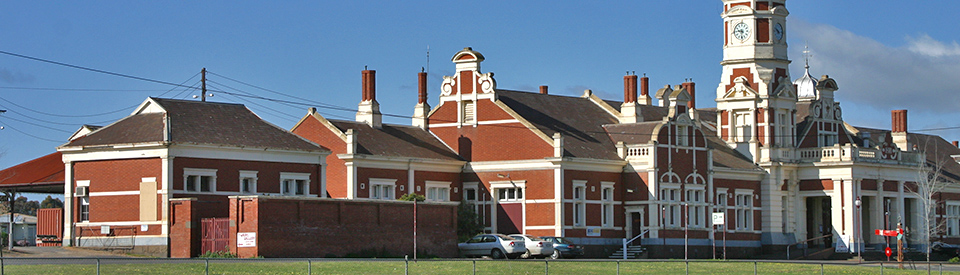
1. Railway Station
When Mark Twain visited Maryborough in 1895 (he wrote about it in Following the Equator) he described it as "a railway station with a town attached" and noted "Don't you overlook that Maryborough station, if you take an interest in governmental curiosities. Why, you can put the whole population of Maryborough into it, and give them a sofa apiece, and have room for more. You haven't fifteen stations in America that are as big, and you probably haven't five that are half as fine. Why, it's perfectly elegant. And the clock! Everybody will show you the clock. There isn't a station in Europe that's got such a clock. It doesn't strike - and that's one mercy." The huge and gracious building – built in Queen Anne style - was completed in 1890. It is a vast 25-room red-brick edifice with stucco trimming. Note particularly the ornate clock tower, the Flemish gables, massive portico, marble dressing tables in the women's toilets, wrought-iron work on the veranda, oak wall panels and one of the longest platforms in the country.
2. Central Goldfields Shire Offices
Located on the corner of Nolan Street and Burns Street, and formerly known as The School of Mines, this handsome building was completed in 1891. In 1903 it was renamed as Maryborough Technical School.
3. The Paramount Cinema
Located next to Mandeville’s Coffee Palace, this classic Art Deco cinema was built in 1926. It still operates as a movie theatre. In its heyday it could hold 1,400 people.
4. Mandeville Coffee Palace
Located at 60 Nolan Street, this charming two storey red brick building was built in 1863 as the Yorkshire Hotel. By the late 1800s it had been taken over by Mrs Mandeville and became the Mandeville Coffee Palace. Check out http://www.finders.com.au/Finders_Archives/Promote/MbuMandeVCP.htm.
5. Phillips Botanical Gardens
Located off Alma Street, the Phillips Botanical Gardens were established in 1874. The site was originally cleared as a dam and the gardens were intended to surround the lake. There are many exotic trees including impressive Bunya Bunya pines and an Australian red cedar. There are extensive walkways and excellent places to relax and enjoy a picnic.
6. State Bank
Located on the High Street, the State Bank of Victoria (now the Commonwealth Bank) was designed by Ballarat Architect, H. R. Caselli in 1886. Over the years it has been an Art Gallery and a restaurant. Since 2005 it has been the Commonwealth Bank.
7. The Bull & Mouth Hotel
Located at 119-125 High Street, this is a gloriously ornate hotel which was opened on the site around 1855. The Victorian Heritage Database (see https://vhd.heritagecouncil.vic.gov.au/places/13473) explains: “In 1904, Maryborough's Jubilee Year, the owner, the former Maryborough resident Thomas Procter of Ballarat, engaged the Ballarat architect W E Gribble and local builder W J Dingle to construct a new two storey hotel, incorporating three shops along High Street … The appointments of the new hotel were the most modern for the period and included piped hot water and a telephone system. On the ground floor were a public bar, a private bar, a parlour, a spacious dining room, a commercial room, a billiard room, a kitchen and a laundry, while upstairs there was a large drawing room, more than fifteen bedrooms and three bathrooms.” It describes the building as “an Edwardian Baroque style two-storey, rendered brick building with an undecorated two-storey wing at the rear along Nolan Street. The ground floor walls have deeply lined rustication, with rusticated pilasters rising up to the first floor, and above is an elaborate parapet concealing the hipped, corrugated iron roof. The corner is emphasised by an oriel window topped by a circular domed turret with a flag pole. On each side of the tower are flanking gables with the name of the hotel and the date 1904 inscribed within. The ground floor windows have segmental arches and some windows have B&M etched into the glass. Outside the first floor windows are small cantilevered balconies supported by decorative consoles and shell-shaped brackets.”
8. AMP Building
On the opposite corner, and still in High Street, is the AMP Building, built in 1926 by Messrs Farnsworth and Sparks. Look up and you will see the figures on top of building, with the symbols Amicus Ray Incerta (“a certain friend in uncertain times”) and a lady holding scales. This is interpreted as "rich or poor, and fair justice for all".
9. McLandress Square
Located at the top of Nolan Street, and considered by many to be some of the finest civic buildings in rural Victoria, is the impressive combination of the Court House, Post Office and Town Hall.
The Court House is the fourth court house in Maryborough. It is recognised as one of the largest court houses outside Melbourne. “It was designed in the Federation Free Classical style by the Victorian Public Works Department architect Samuel Bindley in 1892.” The Victorian Heritage Database explains its importance as being “historically and architecturally significant as the only court house in Victoria to be built in the Federation Free Classical style, which is characterised by symmetry and the use of classical elements without regard to academic correctness, as well as a balustraded skyline, pediments and entablatures.” Note particularly the large paving bluestone which were obtained from the Castlemaine Quarries, some weighing over a ton.
The Post Office was built in 1876-1877 of first class stone mined from McCallum’s Creek and the clock tower added in 1879. The Victorian Heritage Database (see https://vhd.heritagecouncil.vic.gov.au/places/5485) explains that it is a key element in one of the finest precincts of public buildings in Victoria and notes: “The building was designed by architect JH Marsden of the Victorian Public Works Department and built by Peter Cunningham for a contract price of £8266 4s 3d. The post office is in the Italianate palazzo style and features two three arch colonnades and a clock tower. The clock was manufactured by Joseph Bros of Melbourne and the bell by IW Horwood of Castlemaine. In 1892 the post office took over whole building when a new court house was built next door.”
The Town Hall was built in 1887 by George Clayfield at a cost of £6454.5.0. The fountain in front of the Town Hall was built as a memorial to Corporal Gerald Wilkinson, who was the first soldier from Maryborough to die in the Boer War. The Victorian Heritage Database explains its significance as “a notable and largely intact example of a late nineteenth century provincial town hall, and as a major public building designed by the prominent Melbourne architect George Johnson. It is notable for the fine interior of the hall, particularly the gallery and painted ceiling. The Moderne style additions are also significant for their intactness and for the Art Deco interiors. The significance of the Town Hall is enhanced by its location in the Maryborough Civic Square, adjoining the 1878 Post Office and the 1891-2 Court House. The group of three buildings is significant as an outstanding example of late nineteenth century civic design.” For more detailed information check out https://vhd.heritagecouncil.vic.gov.au/places/13472.
10. Old Fire Station
Located in Neill Street, the Fire Station was one of the town’s earliest buildings. It was built in 1861. The existing tower was the third one on the site and constructed in 1888. Engine sheds were added early in the 20th Century. The Central Goldfields Art Gallery is now housed here. An exceptional boom-style belltower was added with a bell from the homestead of the Simsons, the first pastoralists in the district. The Victorian Heritage Database describes it as: “A square brick bell-tower built in 1888 for the Maryborough Volunteer Fire Brigade, with a most unusual timber superstructure.” Check out https://vhd.heritagecouncil.vic.gov.au/places/67719.
13. The Old Library
Located on the corner of Tuaggra and High Streets, this remarkable building was originally the Maryborough Free Library & Reading Room. It was built in 1880 with Charles Walker as the architect. In 1897 it was extended and the unusual façade, with the twin parapets was completed.
14. Maryborough Flour Mill
Located at the corner of Inkerman and Albert Streets (beside the railway line) this 130-year-old flour mill was built by William Phelan in 1880 this impressive three storey flour mill operated for 99 years.
Other Attractions in the Area
Maryborough Driving Tour
On the same Welcome to Maryborough brochure (see https://www.bendigoregion.com.au/sites/default/files/inline-files/215942%20CGSC%20Maryborough%20Self-Guided%20Tours%20Brochure%20FA_0.pdf) is a list of 14 places under the heading Driving Tour.
A. Wesleyan Methodist Jubilee Church
Located on the corner of Clarendon Street and Havelock Street, and built in 1886 by William Phelan, the foundation stone of the Wesleyan Church was laid by Thomas Lancaster. It is now privately owned. Check http://www.churchesaustralia.org/list-of-churches/denominations/methodist-wesleyan-and-other/directory/5200-wesleyan-methodist-jubilee-church-former for more details.
B. Former 404 Primary School
Located at 65-71 Inkerman Street, the Primary School was opened in 1860 by John Gardiner and his wife in a local hall. When the school became overcrowded, the Board of Advice allotted land in 1864 and a wooden structure was built for £145.00 on the current site. The school continued to grow requiring the red brick structure to be built in 1874 and additional buildings added in 1907. Major upgrading of the buildings occurred in 1988. It closed at the end of 2004. The building is now privately owned.
C. Worsley Cottage and Museum
Located at 3 Palmerston Street, the Midlands Historical Society Museum is located in a charming bluestone building - Worsley Cottage. The cottage was built by Arthur Worsley (stonemason) in 1894 for his family. Two extra rooms were built in 1908. There are photographs and memorabilia relating to the local area and the cottage is furnished in period furniture. It is open Tuesday to Thursday from 10.00 am – noon and on Sundays from 2.00 pm to 4.00 pm. At the rear is an old slab squatter's hut from Plaistow. It dates from c1844 and was the home of the Joyce family. The squatter's hut is the oldest known building in the area. For more information check out http://home.vicnet.net.au/~mbhs/Worsley_Cottage/Maryborough_Midlands.html.
D. Bristol Hill Pioneer Cemetery
Located at the bottom of Bristol Hill, the Pioneer Cemetery was in use briefly between 1854 -1859. Most of the graves are unmarked and the occupants unknown. There were up to 486 sites identified as possible graves, of which around 40 had been named on a memorial plaque erected at the front of the cemetery in 2004. There is also a large stone cross. See https://www.goldfieldsguide.com.au/explore-location/52/bristol-hill-pioneer-cemetery/ for more details.
E. Bristol Hill Tower
Located off Miners Drive and built in 1933 (it was a Depression-era project) this impressive tower offers panoramic views of Maryborough. The spiral staircase was built using bluestone from the old gaol buildings. There is a long, and very detailed, description of the tower and its history at https://www.goldfieldsguide.com.au/explore-location/39/bristol-hill-pioneer-memorial-tower.
G. Princes Park
The park is a wonderland of unusual historic buildings including the ticket office, Memorial Gates and a particularly impressive Grandstand. The unusual ticket office was built in 1908 and is the only known Edwardian-style ticket office in the state. It is still used today.
H. Memorial Gates to Princes Park
The Memorial Gates (see https://www.monumentaustralia.org.au/themes/conflict/display/32121-memorial-gates/photo/0) dating from 1885, are an impressive example of cast iron and the pillars, which date from 1928, are a memorial to the local men lost in World War I. Monument Australia records: “The gates at the entrance to Princes Park were erected by the Red Cross Society to record the names of the men and women of the Borough of Maryborough who enlisted in World War One.
I. Princes Park Grandstand
The Victorian Heritage Database (see https://vhd.heritagecouncil.vic.gov.au/places/1982 for more detailed information) notes of the significance of the building: “The 1895 Grandstand is of architectural significance as an important design of the long established and notable architectural firm, Thomas Watts and Sons … The Grandstand uses extensive turned wood decoration and is an early example of all timber decoration that became more widespread in late Victorian and the Edwardian period. The Grandstand is the only example of this type of building by Thomas Watts and Sons, and was modelled on the 1886 South Melbourne grandstand designed by William Elliot Wells which was destroyed by fire in 1926 and a similar grandstand at Victoria Park, Collingwood which was demolished in 1966.”
J. Lake Victoria
Bordered by Park Road, Holyrood Street, Burns Street and Earl Street and listed on the Victorian Heritage Database (see https://vhd.heritagecouncil.vic.gov.au/places/1982 for more detailed information) which notes: “The landscaped Lake Victoria, named in honour of Queen Victoria's golden jubilee, and formed in 1883-5 by prison labour and altered in 1982 is a significant landscape feature. The remains of three rows of Monterey Pines and a row of Weeping Willows around the waters edge forms an attractive landscape. A row of Dutch Elm trees frame the rotunda, and elms north of the grandstand and oval, and elms along the western drain and Holyrood Street, Monterey pines around the lake and along Burns Road are a major landscape feature of the reserve and of aesthetic value. The well positioned and designed buildings and structures positioned to the west side of the oval and the lake in a landscaped reserve are of importance and rare for recreation reserves in Victoria, with no other reserve having a similar collection of 1880-1910 structures. The art deco gentlemen's toilet is contemporary with the nearby registered swimming pool and is of aesthetic and architectural importance. The only similar landscaped recreation reserve in Victoria is at Benalla and on a smaller scale Melville Oval, Hamilton and neither have a collection of buildings, structures, lake and ornamental planting similar or as extensive as Prince's Park.”
K. Band Rotunda
Located off Park Road, the impressive Band Rotunda in Princes Park commemorates the Golden Jubilee of Maryborough in 1905. At the time it cost of £130. The ornate cast iron was supplied by Robinson’s Soho Foundry and the building was. designed by Mr H.N. Phillips who was the Town Clerk. See https://monumentaustralia.org.au/themes/landscape/settlement/display/97864-maryborough-band-rotunda for more details.
L. Olympic Swimming Pool
Located on Lake Road and opened by Sir Frank Beaurepaire in 1940 the swimming pool is listed on the Victorian Heritage Database because it is remarkably intact and features an Art Deco entrance pavilion. The Database records (see https://vhd.heritagecouncil.vic.gov.au/places/5091) that “The swimming complex is architecturally significant as a rare, intact example of a swimming pool complex designed in the late 1930s. The entrance pavilion is architecturally important as a recreational building employing the architectural language promoted by European functionalist architects of the 1920s and 1930s and symbolising a concern for modernity, safety and hygiene.”
M. Simson Memorial Cairn
Located on Kennedy Street, this huge cairn was built from bluestone blocks. The inscription reads: “This cairn constructed from the ruins of the original homestead, and marking the centenary, perpetuates the memory of John, Donald and Hector Simson, first white settlers of the Maryborough District 1840-1940.” The cairn was unveiled in 1940 and the view from the lookout offers panoramic views. A detailed description is available at the Monument Australia website - https://www.monumentaustralia.org.au/themes/people/settlement/display/32123-john-simson-and-hector-simson.
N. Primary School 2828
Located at 60 Gillies Street, the Former Primary School 2828 was built in 1886-1887. It was designed by Education Department architect, Henry Bastow. The design had won a competition in 1873. It is recognised as “a fine and intact example of a Gothic primary school.” It is described in the Victorian Heritage Database (see https://vhd.heritagecouncil.vic.gov.au/places/5723 for more details) as “Maryborough Primary School 2828 reflects the two main periods of its construction. The 1886-7 front section is an asymmetrically planned, Gothic style, red brick, single storey building with a slate roof. It has cream brick string courses and arched door and window openings, those in the projecting gables and in the tower being more elaborate, with hood moulds above. A square tower topped by an octagonal belfry is asymmetrically placed above the front entrance. The 1910 additions at the rear are of a similar red brick with rendered Arts and Crafts-inspired decorative detailing, with roughcast and vents within the gables, prominent brick chimneys, render trimmed parapets, and large straight-headed windows.”
Bull Gully Aboriginal Rock Wells
There are four Aboriginal rock well which were constructed by the Dja Dja Wurrung people who cut them into the sandstone in the area. The wells are considered the best examples of Aboriginal Rock Wells in Victoria. They can be accessed by heading towards Ballarat on Derby Road, turning left on Lean Street, crossing the railway line, turning left into Stoneham Drive and then left into Wells Road. Continue for 2 km and there is a signposted left turn and the wells are 200 metres up the road. For more information check out https://www.bendigoregion.com.au/visit-maryborough-surrounds-victoria/bull-gully-aboriginal-rock-wells.
Goldfields Reservoir
Located 3 km from the centre of Maryborough on Derby Road, the Goldfields Reservoir, on the Ballarat Rd, was built in 1862. A former water supply for the town, it is now a peaceful lake with a picnic area, a scenic walking track and a nature playground. It is used for fishing, swimming and bushwalking. For more information check out https://www.goldfieldsguide.com.au/explore-location/2/goldfields-reservoir.
Paddys Ranges State Park and Maryborough Regional Park
Lying to the south-west of Maryborough between the Ballarat Road and the Pyrenees Highway, Paddys Ranges State Park (1675 ha) and Maryborough Regional Park (270 ha) are woodland areas which consist largely of grey box, yellow gum and red ironbark. Some gold mining relics remain, such as the water race which extends from the Goldfields Reservoir.
Wildflowers (over 230 species and 30 types of orchids) bloom profusely in spring and the park also contains 140 native bird species (some rare) and native animals.
There is a picnic area which is clearly signposted off the Maryborough-Ballarat Rd. It has an information board outlining the park's features, history and possible activities and walking tracks which lead to vegetation communities, cultural areas and scenic spots. For information about the campground check out https://www.goldfieldsguide.com.au/explore-location/5/paddys-ranges-campground.
Timor and Bet Bet
Located 8 km north west of Maryborough is Timor an old gold mining town with some interesting historic relics including an impressive granite arch which was once the entrance to the pump house of the Grand Duke Mine which operated from 1869-1896. The mine had shafts which extended 6 km underground. The Miners Right Store (1852) is one of the state's oldest shops. Behind it is a prefabricated gaol dating from around 1890. The primary school was opened in 1863. Mine shafts dug by Chinese diggers can be found in this area. Unlike the rectangular holes created by European miners, the Chinese dug round shafts as they believed malevolent spirits were capable of concealing themselves in corners.
North of Maryborough, on the road to Dunolly is the ghost town of Bet Bet which contains the ruins of an old church, a couple of homesteads, the railway line and a recreation reserve. The Bet Bet Reef Gold Puddling Site is listed on the Victorian Heritage Database. For more information, check out https://vhd.heritagecouncil.vic.gov.au/places/4971.
History
* Prior to the arrival of Europeans the land was home to the Dja Dja Wurrung Aboriginal people.
* The first Europeans in the district were the Simson brothers who established a sheep station, known as Charlotte Plains, in 1840. The first settlement on the run was Carisbrook.
* Prospectors arrived in the area in 1851.
* In March, 1853 gold was discovered. A 40 pound nugget was found in the district in that year.
* A rush occurred in 1854 with the discovery of payable gold at White Hill, about 4 km north of present-day Maryborough.
* It was estimated that 25,000-30,000 people were on the goldfields by 1853.
* A survey took place in 1854 and a police camp, Methodist church and canvas hospital were set up.
* The Maryborough Advertiser, one of Victoria's oldest newspapers, was first published in 1854.
* In 1855 the Tipperary Riots took place between Irish prospectors and other groups. The riots led to the formation of the Maryborough Mutual Protection Society.
* The town was surveyed in 1855 and allotments were sold.
* By 1856 Maryborough had become the commercial and administrative centre of the goldfields.
* Maryborough became a borough in 1857.
* The Maryborough Highland Gathering was first held on New Year's Day 1857.
* Reef mining began in the district in late 1850s.
* The goldfields reservoir was built in 1862.
* The railway reached the town in 1874.
* Maryborough became a municipality in 1875.
* The Post Office was completed in 1878.
* The town's Botanical Gardens were laid out in 1879.
* A School of Mines was opened in 1889.
* The railway station was built in 1892.
* The local court house was built in 1893.
* A local high school was opened in 1912.
* A Progress Association was formed in 1917. That same year a butter factory was opened.
* The last gold mine closed in 1918.
* Maryborough developed a strong manufacturing base in the 1920s
* The Maryborough Knitting Mills were opened in 1924.
* Patience and Nicholson tool works moved to the town in 1924-1925.
* Maryborough became a city in 1961.
* By the end of the 1960s there were 56 factories in the city.
* In 1985 a bushfire in the district destroyed 180 homes.
* In 1995 it became part of the Central Goldfields shire.
^ TOPVisitor Information
Central Goldfields Visitor Information Centre, Maryborough Railway Station, Station Street, Maryborough, tel: (03) 5460 4511 or 1800 356 511. Open seven days from 9.00 am - 5.00 pm.
^ TOPUseful Websites
There is an excellent local site. Check out https://www.bendigoregion.com.au/visit-maryborough-surrounds-victoria.
^ TOP