Town famous for Mundaring Weir which provides water to Kalgoorlie and Coolgardie.
Mundaring is a pleasant town on the eastern edge of the Perth Hills. It's famous in Western Australia for the Mundaring Weir which, through the remarkable engineering achievements of Charles Yelverton O'Connor, has supplied water to towns in the wheatbelt and the gold towns of Kalgoorlie and Coolgardie. Since the dam was built people have come from Perth to marvel at this watery saviour of the Eastern Goldfields.
Location
Mundaring is located 34 km east of Perth via the Great Eastern Highway.
^ TOPOrigin of Name
It is generally accepted that 'mundaring' is probably a corrupted Noongar word - 'mindah-lung' - which was used by the local people to describe the area.
^ TOPThings to See and Do
Mundaring & Hills District Museum
Located in the Old School at 7225 Great Eastern Highway, Mundaring, the Mundaring and Hills Historical Society was formed in 1989 and since 1997 has operated the Mundaring District Museum which houses a permanent display about people, places and events of historical interest in the district. It is open Monday to Saturday: 9.30 am - 4.00 pm and Sunday: 10.00 am - 2.30 pm. For more information tel: (08) 9295 0540 or check out https://www.mundaringhistory.org.
Railway Reserves Heritage Trail
The growth of railway heritage trails - where old railway routes are converted into cycle and pedestrian trails - has meant that areas of rural land has been opened up to cyclists and walkers. In the case of the Perth Hills the Railway Reserves Heritage Trail retraces 59 kilometres of the old Eastern Railway that in the 1880s connected Fremantle to York.
The route starts at Bellevue, includes a 41 kilometre loop at Mount Helena, and continues on to Wooroloo Reserve.
Railway Reserves Heritage Trail can be joined at Mundaring Station Platform and if you decide to head east you can walk to Sawyers Valley and head to Mt Helena or Chidlow. If you want to head west the route goes to Midland or through Mahogany Creek, Glen Forrest and Darlington to Bellevue. Check out http://www.railwayreserves.com.au/Pages/home.aspx. There is a downloadable brochure.
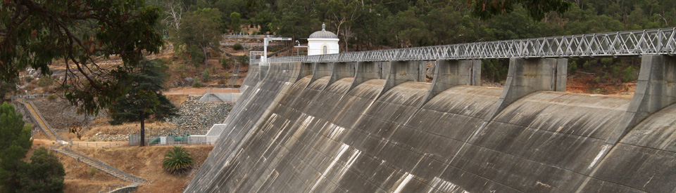
Mundaring Weir - The Story of Charles Yelverton O'Connor
It all began with the goldrushes to Coolgardie and Kalgoorlie. It wasn't just tens of thousands of people arriving and hoping to make their fortunes on the goldfields. It was also about water - the need for it and the lack of it - which not only made life on the goldfields impossibly difficult but also created a situation where typhoid outbreaks literally killed hundreds of children.
So where does Mundaring fit into this tragedy? It was Charles Yelverton O'Connor who had the brilliant idea to dam the water in the Perth Hills and build a pipeline 557 km to the goldfields. He built a weir at Mundaring and it remains a reminder of his remarkable engineering skill.
In 1896 the Western Australian government approved the construction of the Mundaring Weir and the pipeline which would connect the weir and the waters of the Helena River to Kalgoorlie and Coolgardie.
In 1898 a railway line was completed which connected the main Eastern Railway line to the Mundaring Weir site. The result was that a township sprang up overnight to meet the demands of the workers employed to build the Mundaring Weir and, not surprisingly, the rapid increase in population attracted business people who provided goods and services to the pipeline and dam workers.
In his book The Helena Story Edward Quicke describes the establishment of the dam community: "By June 1898 there were 295 men working at the weir ... The area became a vast camp with men living in tents and families in hessian and barrel staves shanties. Conditions were fairly primitive."
The Mundaring Weir was completed in 1900 and the laying of the pipes began in 1902. The construction of the dam and the pipeline are two of the great engineering feats of Western Australia. Without earth moving equipment they changed the future of both Kalgoorlie and Coolgardie.
Most Western Australians today regard Charles Yelverton O'Connor as a man of genius. His story has been fictionalised by Robert Drewe, a Western Australian by birth, in The Drowner and O'Connor's tragedy is a constant reminder of how a good man can be hounded by critics beyond a point of sanity and endurance.
O'Connor was born in Ireland in 1843 and emigrated to Western Australia in 1891 to take up the post of Government Engineer-in-Chief. During the next decade he was instrumental in extending the state's railways and establishing Fremantle harbour.
O'Connor devised the plan to construct the water pipeline from Mundaring to Coolgardie. The plan was laid out in 1895 but it was so vigourously opposed in Parliament that approval to start work wasn't granted until 1898. O'Connor was vilified by people who insisted he was a crazy dreamer. A vicious press campaign was waged. He was so distressed by the attacks that in March, 1902 he committed suicide (his suicide note included detailed instructions on the construction of the pipeline). It is one of the tragic ironies of the story that when the pipeline was completed the following year it immediately liberated wheatbelt and Eastern Goldfields towns from their dependence on unreliable wells, poor rainfall and waterholes. Finally they had a reliable supply of water. Water which had been transported 500 km by train to thirsty communities was converted into a daily output of 5 million gallons being delivered along 557 km of pipes. Such was the success of the program, and such was the approval of the Western Australian community, that the government purchased the railway link from Mundaring to the weir and ran regular weekend trains to the site. It became popular for people to travel from Perth to admire the weir and, when it had rained, to admire the spillway (at the time the weir was the highest overflow dam in the world) which turned into a 'man-made waterfall'. It is a frightening comment on the effects of climate change that the weir has not filled to overflowing since 1996 and water is now pumped into the weir to keep it at a sustainable level.
Today the Weir is still a pleasant picnic spot and No 1 Pumping Station has been converted into a museum honouring the man whose ingenuity converted the scheme into a reality. The experience is genuinely moving. The signage around the weir, and the acknowledgement of the genius of O'Connor is a modest repayment for a man who was so vilified during his lifetime.
In The Swan Valley: A Perspective in Time and Place there is an explanation as to why the Mundaring Dam's wall is straight not curved.
"An interesting feature about the wall of the Mundaring Weir is that it has been built straight across the valley rather than in the convex curve considered desirable for dam walls. With a convex curve, the pressure of the water actually strengthens the wall by compression. At the same time, however, it diverts water to the sides, putting pressure there. The granitic rocks of the Helena River walls have, in ages past, been split by earthquakes and faults, and it was thought that they would not be able to withstand the pressure of the water, so the wall was built straight across the valley.
Mundaring Weir Interpretation Precinct
The Mundaring Weir Interpretation Precinct tells the history of the weir and the pipeline through a series story-telling signs and sculptures by renowned artists. The precinct has become a popular picnic destination with tables, ramps, toilets and barbecues. Gates to the precinct and lookout close at 5.00 pm in winter and 6.00 pm in summer.
No 1 Pump Station Museum
Located at Mundaring Weir the Museum recalls the history and controversy of what is now the longest freshwater pipeline in the world. Today 90 million litres are pumped through the pipeline every day. Tel (08) 9295 2455 or check out http://www.nationaltrust.org.au/wa/no-1-pump-station. Sadly it is now closed with no immediate plans to reopen it.
Perth Hills Discovery Centre
Located at 380 Allen Road - it is off Mundaring Weir Road, the Perth Hills Discovery Centre is operated by the Department of Environment and Conservation and situated within Beelu National Park. It is a good starting point for a number of interesting bush trails including the famous Bibbulmun Track (which passes beside the Centre), the short Catchment Carers Trail and the Munda Biddi Trail which stretches south for over 1,000 km. tel: (08) 9295 2244
Munda Biddi Trail
The Munda Biddi Trail runs for over 1,000 km from the Mundaring Sculpture Park to Albany on the South West Coast. Munda Biddi means "path through the forest" in the local Nyoongar language and, true to its name, it is a gentle trail comprising bush tracks, firebreaks and old railway formations.
Other Attractions in the Area
Karakamia Sanctuary
It is a common joke with enthusiastic naturalists that the early settlers thought the country had few native animals because most of the animals are nocturnal and the English explorers and settlers were usually tucked up in bed when the interesting animals were out foraging and frolicking. This is given particular potency at the Karakamia Sanctuary where they have a special two hour guided dusk walk where you will see animals you have never even heard of - Woylies, Tammar Wallabies and Quenda (Southern Brown Bandicoots). Otherwise it is open during the day and located at Lilydale Road, Chidlow. Bookings for the nocturnal tours are essential and there is a limit of 15 people. Check out http://www.mundaringtourism.com.au/thingstodo.html for a downloadable brochure on the twilight tours.
Lake Leschenaultia
How is this for a wonderful reuse of an old resource? Lake Leschenaultia on Rosedale Road, Chidlow was built in 1897 by the Western Australian Government Railway. It was called Chidlows Well and was built specifically to replenish the water in the steam engines travelling between Perth and York. Today - renamed Lake Leschenaultia - it is a delightful 168 ha lake surrounded by bushland and ideal for canoeing, swimming, cycling and family picnics. The surrounding bushland has Marri and Wandoo trees, wildflowers in spring, and the fauna includes ducks, geese, herons, swamp hens, kangaroos, possums, bandicoots and echidnas. It is open all year round.
History
* Prior to European settlement the area to the east of the Canning River was occupied for thousands of years by the Beeloo or Beelu people who were part of the Wajuk language group.
* The first European into the area was the explorer Ensign Robert Dale who, in 1829, traced the Helena River upstream to a point near the present site of the Mundaring Weir. It is probable that Dale named the river after his sister, Helen.
* In 1831 Dale surveyed a track from Guildford to York and it was on this road that the settlement of Mundaring slowly grew.
* In 1834 William Burges, who was mapping the Helena River, became the first person to use the name 'Mundaring' for the area.
* By the 1840s developers and entrepreneurs were buying up land in the area. They were buying but not settling.
* It wasn't until the 1880s that settlers began farming the land in the district.
* The first freehold land was granted in 1882 and in 1889 a sawmill opened and timber cutters moved in to exploit the extensive stands of jarrah and karri.
* The Eastern Railway opened in 1884 but it was not until 1891 that trains began stopping at Gugeri's Siding which eventually became Mundaring.
* The decision in 1896 to build the Mundaring Weir and pipeline to Kalgoorlie and Coolgardie changed the nature of the town completely.
* In 1898 a railway spur line connected the main Eastern Railway line to the Mundaring Weir site.
* By June 1898 there were 295 men working at the Mundaring Weir.
* Mundaring Weir was completed in 1900 and the laying of the pipes began in 1902.
* The local hotel, the Goldfields Weir Hotel, became hugely successful and by 1909 the Western Australian Government had taken over the spur line to Mundaring Weir and was running excursions to the dam on Sundays.
* Today the Weir is a popular picnic spot and No 1 Pumping Station has been converted into a museum .
^ TOPVisitor Information
Mundaring Visitor Centre, 7225 Great Eastern Highway, Mundaring, tel: (08) 9295 0202. It is open 7 days a week, Monday –Saturday 9.30 am – 4.00 pm and 10.00 am- 2.30 pm Sundays.
^ TOPUseful Websites
Mundaring Tourism have their own website. Check out http://www.mundaringtourism.com.au/ which offers information about accommodation and eating in the area.
^ TOP
Thank you
Great write up I look forward to your FB blog.
Natures Paradise Health Retreat and Spa is the only health retreat in Western Australia, and located close to the weir.