Sublime region of bush walks, waterfalls and lookouts in the Gold Coast hinterland.
For tourists there is really no need to go to Nerang. It is essentially a suburban development to the west of the Gold Coast and south of Brisbane - a commuter suburb with few attractions. Once a quiet rural town it now has wide roads, recent project home developments, modern shopping complexes and the usual features which characterise large centres of population and commerce. However the area to the west of the town is so special that driving through Nerang on the way to Murwillumbah and New South Wales, through a 366,455 ha World Heritage collection of National Parks, is both memorable and enchanting. The beautiful lookouts, the wild beauty of both Lamington National Park and Springbrook National Park; the excellent bushwalks; the rich soils - a product of the huge volcano which produced Mount Warning; and the marvel that is Natural Bridge make the hilly lands between Nerang and Murwillumbah nature's antidote to the suburban high rise and over-development of the Gold Coast.
Location
Nerang is located 71 km south-east of Brisbane via the Pacific Motorway. 33 km beyond Nerang is Natural Bridge in the Springbrook National Park.
^ TOPOrigin of Name
It is claimed that "Nerang" is a corruption of a local Aboriginal word, probably a Gombemberri word, "neerung" which meant "shovelnose shark". The sharks used to come up the Nerang River looking for food. It has also been suggested that the word meant "little river".
^ TOPThings to See and Do
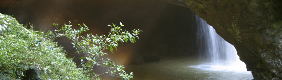
Natural Bridge
Located 37 km south of Nerang, off the Nerang-Murwillumbah road, is Natural Bridge. It is a particularly beautiful small valley and grotto in which an arch, formed 23 million years ago by lava from Mount Warning, has created a cavern. Erosion from a creek (which runs into the Nerang River) has created a hole in the lava and formed a waterfall through the roof of the cavern which, in muted light, cascades into a pool below. To appreciate the scale of the volcano it is worth noting that, at the time of the eruption, it was 80 km across (Tamborine Mountain is part of it as are the lava outcrops at Burleigh Head and Coolangatta and Mount Warning near Murwillumbah).
An excellent information board on the path to Natural Bridge explains, with diagrams, that "The basalt rock bridge we see today was once the lip of a waterfall. Beneath the hard basalt, a softer rock form called agglomerate was eroded by the waterfall, forming a cave beneath. Upstream from the fall, a deep pool was drilled in the creek bed by the swirling action of rocks. This pool eventually broke through the cave roof, allowing the water to plunge through the hole into the cave below."
The road leads to Natural Bridge leads through a shady subtropical rainforest grove full of birdlife (eastern yellow robins, whipbirds, catbirds, logrunners, wompoo pigeons and brush turkeys) and local fauna (pademelons, grey eastern water dragons, green tree frogs, brushtail possums, bent winged bats, sugar gliders, spotted tail quoll, bush rats, glowworms). There is a clearly signposted circuit walk which leads through the rainforest to a lookout overlooking the falls and the hole in the cavern roof. It crosses a creek, passes another elevated viewing area, then moves down to creek level, where it is possible to enter the cavern where forest light shafts down through the opening, illuminating the base of the falls. The path then crosses the creek again and climbs back up to the parking lot. The information board at the start of the walk suggests that the walk is easier if you head in a clockwise direction.
The 'Bridge' is located in Springbrook National Park, in an area once occupied by the Gombemberri Aboriginal people but settled, from the 1870s, by Europeans who came to the area to exploit the rainforest timber. A giant red cedar taken from a spot near the Natural Bridge in 1893 was displayed at the Paris World Fair. The remnant rainforest in the park, which grew from the rich volcanic soils, gives some idea of the environment which characterised the entire Numinbah Valley before colonisation. The circumstances were ideal. The annual rainfall is around 2500 mm. The Natural Bridge was first declared a Scenic and Recreation Reserve in 1922 by which time much of the valley had been cleared and dairy farms were being established. The most distinctive timber in the area are the hoop pines. There are vines and staghorns as well as huge trees rotting on the forest floor. At night the glow-worms, which can be seen in their thousands, cover the cavern roof. These insects are the larvae of a fungus fly and they glow to attract insects to their webs. The glow-worms are frail and torches must not be used. Candles and other flames, flash photographs, smoking and insect repellant are also forbidden.
Two Remarkable National Parks
Springbrook National Park and Lamington National Park are part of a 366,455 ha World Heritage area known as the Central Eastern Rainforest Reserve. They contain types of rainforest which are recognised as some of the best examples in the world and which are inhabited by a rich and diverse wildlife. It is remarkable to think they are located only a short distance from one of the most densely populated tourist areas in the country. Twenty million years of erosion have produced a range of rugged, rocky peaks and deep gorges with the skyline dominated by rhyolite cliffs at both Springbrook and Lamington National Parks.
Springbrook National Park
The easiest way to access Springbrook National Park is via Mudgeeraba on the Gold Coast-Springwood Road. There are seven great walking tracks along the route which terminates at the Best of All Lookout on the NSW-Queensland border.
The detailed http://www.nprsr.qld.gov.au/parks/springbrook/about.html#walking provides clear information on distance and degree of difficulty for three circuits, two tracks and two lookouts. It observes: "Several vantage points on the plateau provide extensive views of the surrounding ranges, foothills and the coastline. Constructed lookouts, providing safe viewing, are easily accessible via a short walk. Be aware that these lookouts are often shrouded by cloud, even when the weather is fine and sunny on the coast. For the best views, visit on clear, smoke-free days."
Wunburra Lookout
This is only 30 metres (it takes about five minutes) from the car park but has views over Purling Brook Valley, Mount Cougal and Little Nerang Dam. A good place to start and to observe the geological forces which have helped to shape this unique area.
Canyon Lookout
This is only 30 metres (it takes about five minutes) from the car park and has views over both the Twin and Rainbow Falls as well as the sheer cliffs of The Canyon. On a clear day it is possible to see the Pacific Ocean and the geology of the area - the landslides and erosion - is easily observable.
Coomoolahra Falls Lookout Track
A short, 200 metre walk which offers dramatic views of the 60 m high Goomoolahra Falls and, on a clear day, a panoramic view across Moreton Bay to Stradbroke and Moreton Islands.
Best of All Lookout Track
Located on the border between NSW and Queensland this amusingly named lookout (a great example of self praise) offers a "Walk through ancient Antarctic beech forest to a view of northern New South Wales dominated by Mount Warning, the lava plug at the centre of the erosion caldera of the extinct Tweed shield volcano. The small pocket of Antarctic beech forest Nothofagus moorei is one of our remaining links to the ancient forests of Gondwana that occurred here during a past cooler climate. Nothofagus forests were once widespread across the continent and provided a habitat for many animals that have long since disappeared from our landscape." The walk takes around 30 minutes.
Purling Brook Falls Circuit
This is one of the great walks in the area. It covers a total of 4 km return, takes about two hours and, as the National Parks website explains, it passes: "through open eucalypt forest of New England ash Eucalyptus campanulata, where fire-adapted species such as lepidozamias, hakeas and various wildflowers grow, before descending into the gorge to view the falls from below. After crossing the suspension bridge a steady climb through forest brings the walker back to the picnic area. Water flowing over Purling Brook Falls is high quality because its catchment is protected in the Gondwana Rainforests of Australia World Heritage Area." The walk to Warringa Pool is an additional two kilometres but well worth the effort - if you are fit enough.
Twin Falls Circuit
This walk is 4 km return and takes around two hours. If you head off in an anti-clockwise direction you will pass behind two waterfalls and discover palms, rock ferns and brush box eucalypts.
Warrie Circuit
This is a serious, full day walk (it is 17 km return and takes between 5-6 hours for experienced bushwalkers) and involves sheer cliffs, waterfalls and creek crossings. As the National Parks website explains it is: "The longest and most interesting track on the plateau follows the base of The Canyon cliffs to Goomoolahra Falls before descending into the mossy green depths of the rainforest. The track (named with the Aboriginal word 'Warrie', meaning 'rushing water') crosses several creeks and gullies. The track reaches the 'Meeting of the Waters', where all watercourses draining The Canyon meet, then climbs up the western side of the gorge. The moist and shady conditions at the base of Goomoolahra Falls provide an ideal habitat for the giant spear lilies Doryanthes palmeri. This succulent herb is one of only two members of the Doryanthiacea plant family, which is endemic to Australia." There are excellent detailed maps of both the general area of the park and the four specific walking areas in the park. Check out http://www.nprsr.qld.gov.au/parks/springbrook/pdf/springbrook-map-insets.pdf.
Lamington National Park
Lamington National Park, which was declared in 1915, covers 20,590 ha of subtropical rainforest just 50 minutes drive from Surfers Paradise and the Gold Coast. It is part of the Gondwana Rainforests of Australia World Heritage Area which incorporate the world's largest section of subtropical rainforest, most of its warm temperate rainforest and almost all of its Antarctic beech cool temperate rainforest. These trees are directly related to the trees which existed on Gondwana 55 million years ago. The park lies on the southern edge of the Mount Warning volcanic area. The crater of an 80 km wide, ancient and extinct volcano that first erupted between 20-23 million years ago. Consisting of thickly forested valleys and ranges rising to over 1100 metres, it features waterfalls, streams, caves, fern gullies, cliffs, outstanding views and many kilometres of bushwalking tracks.
The park is divided into two sections: Binna Burra in the north-east and Green Mountains in the south-west. Maps of both sections can be downloaded at http://www.nprsr.qld.gov.au/parks/lamington which is ideal for planning walks.
Binna Burra
The Binna Burra section is 35 km from Nerang. This section of the park has a total of 15 tracks ranging from a 1.2 km Rainforest Circuit through a Bellbird Lookout Track (2 km, 1 hour), Caves Circuit (5 km, 90 minutes), Tullawallal Circuit (5 km, 90 minutes), Gwongoorool Track (6 km, 2 hours), Lower Bellbird Circuit (12 km, 4 hours), Daves Creek Circuit (12 km, 4 hours), Coomera Circuit (17.4 km, 7 hours), Mount Hobwee Circuit (18.2 km, 8 hours), Araucaria Lookout Track (17.8 km, 7 hours), Wagawn Track (18 km, 8 hours), Ships Stern Circuit (21 km, 8 hours) and the Illinbah Circuit (16.6 km, 8 hours). Check out http://www.nprsr.qld.gov.au/parks/lamington/about.html#Half-day_walks_Binna_Burra for detailed information on all these walks.
Green Mountains
Walking tracks lead through rainforest to lookouts, waterfalls and gorges. This section of the park has a total of 9 tracks ranging from a 1.4 km Rainforest Circuit (30 minutes) through to the Python Rock Track (3.1 km, 1 hour), Morans Falls Track (4.4 km, 90 minutes), Box Forest Circuit (10.9 km, 4 hours), West Canungra Creek Circuit (13.9 km, 5.5 hours), Toolona Creek Circuit (17.4 km, 6 hours), Albert River Circuit (21.8 km, 7 hours), Border Track (21.4 km one way, 7 hours) and Mount Merino Track (21.6 km, 8 hours). Check out http://www.nprsr.qld.gov.au/parks/lamington/about.html#Half-day_walks_Green_Mountains for detailed information on all these walks.
Winter visitors (May to October) to the parks should note that temperatures can be quite cool in the day (12°C) and drop to freezing at night. In summer storms can strike suddenly, dramatically decreasing temperatures and making tracks slippery.
Hinze Dam and Advancetown Lake
Located 15 km south-west of Nerang, the Hinze Dam (named after the huge Russ Hinze who was a minister in the infamous Bjelke-Petersen government) was built in 1976, raised in 1989 and upgraded in 2011. The dam, which is now the main source of water from the huge Gold Coast region (now the sixth largest city in Australia) holds 310,730 megalitres. The dam, known as Advancetown Lake, is a popular recreation retreat for Gold Coast and Brisbane residents (see http://www.seqwater.com.au/sites/default/files/PDF%20Documents/Recreation/Hinze%20Dam%20Recreation%20Guide_web_two%20page%20spread.pdf for a downloadable brochure on the activities available) with two boat ramps where electric powered watercraft, sail craft and paddle craft can be launched. There are four designated picnic areas - Picnic Parkland, Pocket Park, Waterside Park and the Western Boat Ramp and a children's playground at Picnic Parkland. Swimming in the lake is not permitted but fishing is. Check out http://www.seqwater.com.au/water-supply/dam-operations/hinze-dam for up to date information on the dam.
History
* Prior to the arrival of Europeans the area had been occupied for tens of thousands of years by the Gombemberri Aboriginal people.
* The area around the Nerang River was first surveyed in 1842, after the land around Moreton Bay had been opened up for settlement.
* In 1860 the Queensland Native Mounted Police opened fire and killed some Gombemberri people on the banks of the Nerang River.
* Settlement of the area occurred quickly and from 1862-64 settlers attempted to grow cotton was grown.
* In 1863 Manchester Cotton Company acquires land in the area.
* By 1865 the dominant crop in the area was sugarcane
* The town was surveyed in 1865.
* The first town plots were sold in 1866.
* Cobb & Co commenced a daily service from Nerang to Brisbane in 1871.
* By 1871 the German Lutherans established the Aboriginal Industrial Mission Reserve on the banks of the Nerang River.
* Through the 1870s the town grew rapidly.
* The town's first hotel was built in 1872.
* A post office was built in 1874.
* By 1875 the town had its own public school, Nerang State School.
* The South Coast railway was extended to Nerang in 1889. Its arrival ensured that the town survived and prospered.
* In 1891 the population of the town was 268 people.
* The council chambers were completed in 1927.
* In 1949 the Shire of Nerang became part of the Shire of Albert.
* In 1995 the Shire of Albert was amalgamated into the City of the Gold Coast.
^ TOPVisitor Information
There are a number of Visitor Information Centres on the Gold Coast. The nearest to Nerang are Gold Coast Tourism Visitor Information Centre, 2 Cavill Avenue, Surfers Paradise, tel: 1300 309 440 and Gold Coast Airport Visitor Information and Booking Centre, Domestic Terminal, Bilinga, tel: (07) 5536 4709.
^ TOPUseful Websites
There is a useful history, with lots of historic photographs, at http://www.queenslandplaces.com.au/nerang-and-nerang-shire.
^ TOP