Town closest to the famous Twelve Apostles
Port Campbell would be little more than a windswept fishing village nestling on the eastern side a natural gorge at the mouth of Campbells Creek if it was not for its location as the main town on a stretch of Australian coastline which is regarded by many as the most beautiful in the country. Port Campbell is the natural starting point for travellers wanting to see the very best the Great Ocean Road can offer: Loch Ard Gorge, London Bridge (or the remnants of it) and, of course, the Twelve Apostles - all of which are being steadily reduced by the inexorable forces of the Great Southern Ocean and the vulnerability of soft limestone. Port Campbell is still the only sheltered refuge between Apollo Bay and Warrnambool. It is a popular holiday resort.
Location
Port Campbell is located 221 km south-west of Melbourne via Geelong and Colac and 283 km via the Great Ocean Road.
^ TOPOrigin of Name
Port Campbell was named after a Captain Alexander Campbell who was known as 'the last of the buccaneers'. He traded between Victoria and Van Diemen's Land and, being in charge of the whaling station at Port Fairy, began taking shelter in the bay, the only shelter along the coast, in the early 1840s when he was sailing between King Island and Port Fairy.
^ TOPThings to See and Do
In the Town
Beach and Jetty
The Port Campbell National Park has very few beaches that are safe for swimming. The beach in the town is relatively safe. It is only 200 metres wide and has a surf lifesaving club which operates in the summer months. The beach is protected by the narrow harbour/port entrance and so the waves are rarely more than 0.5 m high. Ocean swimming is not recommended anywhere in Port Campbell National Park. The Port Campbell Jetty is used by professional fishermen to launch their boats. See http://beachsafe.org.au/beach/vic451 for more information.
Port Campbell National Park
Port Campbell National Park is famous for its rock stacks and wave-sculptured limestone formations. It stretches for 65 km along the coastline (17 km eastward and 48 km westward from Port Campbell) and is edged by the Great Southern Ocean. It was proclaimed in 1964 and extended in 1981. Over the years it has grown from its original size of 700 ha to its current size of 1,830 ha. It features sheer cliffs offshore islets, towering rock stacks, gorges, arches, blowholes and other spectacular coastal scenery.
The Geology of the Park
The Port Campbell National Park and Bay of Islands Coastal Park Plan has an excellent description of the geology of the area:
"The geology of the Parks comprises marine limestones and marls of the Tertiary (Oligocene and Miocene) age overlain by Pleistocene dune limestones. The exposures in the coastal cliffs include the type sections of three major geological units of the Heytesbury Group (Clifton Formation, Gellibrand Marl and Port Campbell Limestone). Some of the Tertiary beds are richly fossiliferous, and fossil soils are preserved in the Pleistocene dune limestones.
Precipitous or undercut cliffs up to 60 m high are the dominant coastal landform and create some of the most spectacular coastal scenery in Australia. Strong wave action is very effective in eroding these relatively soft, horizontally-bedded rocks, which are fractured along intersecting joint planes. Where the joints are closely spaced, a deeply indented coastline with narrow, elongated bays and headlands has developed, as at Loch Ard Gorge, The Grotto and the Bay of Martyrs."
The coastline was formed around 10-20 million years ago when billions of tiny skeletal fragments accumulated beneath the sea gradually creating limestone formations. The sea then retreated leaving the soft limestone exposed above sea-level to the waves and wind of the Great Southern Ocean which has carved out arches, rocks stacks, blowholes and coastal gorges including London Bridge, The Arch, The Twelve Apostles, The Grotto and Loch Ard Gorge.
There are opportunities for sightseeing, surfing, snorkelling, walking, photography and surf fishing. As the Great Ocean Road passes right alongside most of the coastline it makes for some excellent scenic driving.
Flora in the Park
The park has fragile grasslands and heathlands which support six nationally significant plant species including the Metallic sun orchid, Swamp greenhood, Scented Spider-orchid, Clover Glycine, Square Raspwort and Lime Fern. In the protected areas of the coast it is possible to see sea box, coast beard heath, bower spinach, coast daisy bush, small daisies and cushion bush. In the wilder terrain there are she-oaks, dogwoods, correa, messmate, trailing guinea-flower, woolly tea-tree and scented paperbark.
Fauna in the Park
Between June and October the cliffs of the Park are ideal for viewing Southern Right Whales. Humpbacks can be seen in May, June, September, October and November. At both the Twelve Apostles and London Bridge lookouts it is possible to see little penguins returning to their nests at dusk. It has been estimated that there are around 800 birds at the Twelve Apostles. There are also dolphins, porpoises and seals in the waters.
The birdlife is richly diverse and includes Otway white goshawks, pied cormorants, honeyeaters, southern emu-wrens, superb fairy-wrens, swamp harriers and the rare rufous bristlebird which lives near the ground in areas of sword-grass tussocks and coast beard-heath. The rufous bristle bird can sometimes be seen around Loch Ard Gorge. Peregrine falcons can be seen flying above the cliff-tops. Pelicans, ducks, black swans and egrets inhabit the estuaries and wetlands. Penguins, terns and dotterels inhabit the shoreline and hooded plovers nest in exposed beach locations. Australasian gannets, wandering albatrosses, nankeen kestrels and short-tailed shearwaters (known as mutton birds) can be seen out to sea.
The terrestrial fauna includes Eastern grey kangaroos, swamp wallabies, red shouldered wallabies, southern brown bandicoots, spotted tail quoll, swamp antechinuses, potoroo, the rare eastern pygmy possum, echidnas and, of course, reptiles - copper heads and tiger snakes are common and the swamp skink and glossy grass skink are rare.
^ TOPOther Attractions in the Area
To the East of the Town
Loch Ard Gorge and Muttonbird Island
About 7 km east of Port Campbell is a clearly marked road which leads to Loch Ard Gorge, a natural gorge which was named after the three-masted iron clipper the Loch Ard which left England bound for Melbourne on 2 May, 1878 under the command of Captain Gibbs (he was only 29 at the time) and was shipwrecked on 1 June. At the time of the shipwreck it was carrying only 17 passengers and a crew of 37. As the ship travelled along the coast it entered a heavy fog near Port Campbell. Visibility, combined with huge waves and strong winds, drove the ship towards land. It struck a reef at Muttonbird Island so violently that a mast collapsed and the whole of the wooden top deck was torn from the hull. Being so exposed it needed only a single huge wave to sink the vessel. Of the 54 people aboard only two survived - Eva Carmichael and a ship's apprentice, Tom Pearce. Pearce managed to swim ashore and then managed to save Eva who had clung to part of the ship's spar for five hours. Eva was wearing only her night dress. Pearce managed to carry her to a cave where he covered her with grass before scouring the coast hoping to find other survivors. At daybreak he climbed the cliffs and found two men from Glenample Station. Pearce and Carmichael were taken to Glenample to recover. The bodies of Eva Carmichael’s young brother and sister Evory and Raby Carmichael were recovered and buried in a cemetery near the gorge.
Pearce's bravery and the story of the shipwreck quickly spread to Melbourne and Sydney. He became known as "the hero of Loch Ard" and was awarded a gold medal from the Humane Society in Melbourne, a gold watch and £1000 from the Victorian Government, a set of nautical instruments from the people of Sydney and some new clothes from the citizens of Warrnambool.
There is a good Park Notes from Parks Victoria (downloadable at http://parkweb.vic.gov.au/__data/assets/pdf_file/0009/315567/Park-note-Port-Campbell-NP-Loch-Ard-Gorge-walks.pdf) which outlines three walks from the Loch Ard Car Park.
(1) The Wreck of the Loch Ard - 1.4 km, 50 minutes. In the immediate area of the car park this walk is based around the wreck, takes in a plaque at the top of Loch Ard Gorge, the cave where Eva sheltered while Tom went looking for help, and the cemetery where the dead were buried.
(2) Living on the Edge - 3.2 km, 90 minutes. The second walk focuses on the geology of the area including the Island Archway, The Blowhole, Thunder Cave, Elephant Rock and Broken Head. It includes Muttonbird Island Lookout which looks across at Muttonbird Island, in the past known as 'The Sow' when the Twelve Apostles were known as 'The Piglets'. Muttonbird Island is only 60 metres from the mainland and is home in season to an estimated 200,000 short-tailed shearwaters which migrate 30,000 km every year passing summer in the northern Pacific Ocean and returning in the last week of September to nest in rookeries in Bass Strait. They fly in on summer evenings to their nests on the island. They can be seen from October to April but January and February are the best times.
(3) Geology - 900 m return. It takes around 40 minutes and focuses on the forces that shape the coastline.
Twelve Apostles and the Twelve Apostles Visitor Facility
Historically it was always a bit chaotic at the Twelve Apostles. People parked, viewed, wondered whether they could get down onto the beach, and there was no defined Visitor Information. Then the excellent new Visitor Facility was established with major interpretation displays highlighting the natural attractions of the area, the local Aboriginal culture, the European history (especially the shipwrecks) as well as a cafe and gift shop.
The Twelve Apostles are no longer twelve. There are eight 'stacks' which are vertically jointed and flat-bedded limestone with the largest stack reaching 65 metres above sea-level. It is argued that the best photographs are taken in the early morning but there are impressive examples of excellent images taken in the late afternoon.
The new visitor centre is located over the road from the Twelve Apostles. It has a large car park and walkways to the viewing areas.
For those who want a birds-eye view there are helicopter and small aeroplane flights over the coast which go as far west as Port Campbell and sweep across the Twelve Apostles.
Gibson Steps
Located about one kilometre east of the Twelve Apostles Visitor Facility are the Gibson Steps, a set of steps from a car park which lead down to Gibson Beach which provides access, at beach level, to the Twelve Apostles. The original steps were carved into the rock by Hugh Gibson, an early owner of Glenample Homestead. They have been improved over the years and offer a sea level view of the "stacks" that make up the Twelve Apostles. The two that are viewable from the beach are known as Gog and Magog. Fishing is possible from the beach but it is unwise to go swimming.
Glenample Homestead
Near the turnoff to the Gibson Steps is Glenample Homestead, the original homestead for the 2,000 acre (809 ha) property established by Hugh Gibson in 1869. The property is now a Parks Victoria museum although it has been closed since 2007.
Princetown
Princetown is 6 km east of the Twelve Apostles Visitor Facility. It lies at the mouth of the Gellibrand River, has a post office, a pub (Twelve Apostles Tavern), general store and the Apostles Camping Park and Cabins (tel: 03 5598 8119). There is the Princetown Recreation Reserve and Camping beside the Gellibrand River.
To the West of the Town
Town Lookout and Port Campbell Discovery Walk
You can drive or walk to the Town Lookout. Take the road west and there is a turnoff, the first to the right, or you can walk across Port Campbell Beach, cross the mouth of Campbells Creek and it is a pleasant walk around the cliffs. This trail, known as the Port Campbell Discovery Walk, offers excellent views over Port Campbell and winds around the coast to Two Mile Bay. It is an ideal introduction to the coastal heathland.
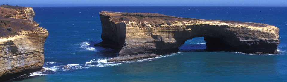
The Arch, London Bridge and the Grotto
There are some good maps available for download at http://www.gippslandinfo.com.au/images/gipps/Port-Campbell-NP-Visitor-Guide.pdf. They direct the visitor to The Arch and viewing platforms over London Bridge. London Bridge was a natural archway and tunnel in an offshore rock formation caused by waves eroding away a portion of softer rock. It collapsed on 15 January 1990. Two people were on the bridge at the time but no one was injured. Artificial burrows have been built to encourage the nesting of fairy penguins. There is no access to the beach. It is located 7 km south of Port Campbell and has good parking facilities and plenty of vantage points where visitors can inspect the formations and take photographs.
About another 2 km west, via the Great Ocean Road, is a turnoff on the left which leads to a lookout over 'The Grotto' - a geological formation created when sinkholes in the limestone cliffs met with a receding cliff line.
^ TOPHistory
* Prior to the arrival of Europeans the area was inhabited by people from the Girawurung Aboriginal language group. Shell middens along the coast have provided evidence of the presence.
* By the early 1800s sealers and whalers were moving along the coast.
* By the 1820s Bass Strait had become a major route for cargo ships.
* It was Captain Alexander Campbell in the 1840s who discovered that Port Campbell was the only safe shelter on the coast.
* Governor La Trobe travelled along the coast in 1845-46 and noted: "I think a boat might possibly land at Port Campbell in most weathers; but with this exception, I do not know a single spot on the whole coast from Hopkins to Cape Otway where a landing could be effected with any chance of certainty."
* Pastoralists moved into the area in the 1840s. Duncan Hoyle established Buckleys Creek Pastoral Run in 1846.
* By 1847 Charles Brown was leasing the Glenample Pastoral Run which was known as Kernan's Station. This year the coast around Port Campbell was surveyed.
* In 1869 the pastoralist Hugh Gibson built Glenample Homestead from locally quarried sandstone.
* A beacon was established on the headland in 1874.
* In 1875 that the town site was surveyed.
* The first land sales occurred 1878.
* In 1878 the Loch Ard was shipwrecked on Muttonbird Island at what is now known as Loch Ard Gorge.
* By 1880 a pier had been built near where the jetty now stands.
* In 1882 the town was the subject of one of Australia's most famous hoaxes when some trickster decided to fuel paranoia about Russia by informing The Age that a Russian fleet ready to attack Melbourne and the invasion was to begin at Port Campbell. Some Melbourne newspapers, eager to get an exclusive, actually reported massacres and thousands of Russian troops moving towards Melbourne.
* By the 1890s Port Campbell was opening up to tourism and there were plans for a railway line but it got no further than Timboon in 1892.
* In 1964 the Port Campbell National Park was officially reserved.
* The National Park was extended in 1981.
* Today Port Campbell's economy is driven by tourism. There is also a fishing and crayfish industry.
^ TOPVisitor Information
Twelve Apostles Visitor Information Centre, 26 Morris St, Port Campbell, tel: 1300 137 255. Next door is the Parks Victoria office, tel: (03) 5598 6382. At the Twelve Apostles is the Twelve Apostles - Visitor Facility, tel: 1300 137 255.
^ TOPUseful Websites
The website http://visit12apostles.com.au/ is remarkably useful and detailed. There is an excellent guide book on the entire coast. Check out http://www.rodneyhyett.com.au/great-ocean-road-guide-book.html for details.
^ TOP
Did you know that Julius Sinn, owner of the port Campbell Hotel around 1930s, beat Walter Lindrum, world champion at snooker. I have a paper cutting with the news article. My father Kevin Taggart sat on the pub’s steps as a 12 yo boy. His uncle was Julius Sinn. Dad was born in Hamilton on 6/7/1922.