Major holiday destination and site of a famous festival, located west of the Great Ocean Road
Port Fairy is a charming historic holiday town with an excess of attractions for visitors. There are museums, historic walks, charming stretches of coastline which are ideal for walking, a fascinating harbour, charming olde worlde cottages and the famous Port Fairy Folk Festival, which is held each March and is widely recognised as the best folk festival in the country.
Location
Port Fairy is located 288 km west of Melbourne on the eastern headland of Portland Bay.
^ TOPOrigin of Name
Around 1810 Captain James Wishart, a sealer working the southern coast, anchored his cutter, The Fairy, at the mouth of the Moyne River. He explored the Moyne River and revisited the area regularly. By the mid-1820s the 'harbour' was known as Port Fairy, probably after Wishart's cutter.
^ TOPThings to See and Do
Port Fairy Historic Walks
The Port Fairy Visitor Information Centre has copies of the Port Fairy Historic Walks brochure but it can also be downloaded at https://www.portfairyaustralia.com.au/assets-portfairy/Uploads/Port-Fairy-Historic-Walks-Map-.pdf.
In total it identifies 36 places of historic interest between the Princes Highway and the town's Historic Wharf Precinct. Most of the buildings are located between Gipps Street and William Street and the most significant include:
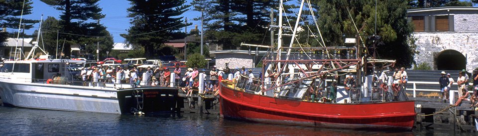
Port Fairy Wharves
Port Fairy is a town for mooching and wandering. Get down to the Moyne River and wander along Gipps Street. The walk along the wharves beside the river, heads into the town (if you head north) or towards Griffiths Island if you head south. The wharves are popular with anglers and are used by commercial fishermen who ply the waters of the Great Southern Ocean.
1. Moyne Mill
Located in Gipps Street near the wharf, the Old Moyne Mill dates from c.1866. It was built by Dr Alexander Russell and originally had five storeys. It was the Port Fairy Butter Factory and is sometimes referred to as Joseph Goble's Flour Mill.
3. John Mills Cottage
Known as Captain Mills Cottage this was the home of John Mills, one of the brothers who were the first settlers in Port Fairy. Located at 40 Gipps Street it is a fine example of a cottage dating from the early 1840s, probably 1843. From this house Mills started his importing business which saw him bringing shoes, rum and building materials to the district. The back section of the cottage is believed to be the oldest European building in Victoria.
4. Port Fairy History Centre - Court House
Located at 30 Gipps Street the Port Fairy History Centre has an extensive display of memorabilia and photographs from the late 19th and early 20th century. It is located at the old Court House which dates from 1859 and was built to a design by the Public Works Department. It was built out of local bluestone and, as the local historical society explains: "The Court House is classified by the National Trust as essential to the heritage of Australia ... It was built in 1859, with the portico added in 1869, and a further three rooms at the rear in 1874, to make the building as it is today. At the time of construction, it was the only Courthouse in the Western District of Victoria, and housed sittings of the Supreme Court and County Courts as well as General Sessions. It remained in use until 1988, when its last function, as a Licensing Court, was transferred to Warrnambool." It is open Wednesdays and Saturdays from 2.00 pm to 5.00 pm and Sundays from 10.30 am - 12.30 pm. Check out http://www.historicalsociety.port-fairy.com for more details.
5. Customs House
Located on the corner of Campbell and Gipps Streets, the Customs House is a modest building which is dwarfed by the large Court House next door. The Victorian Heritage Database notes of the building that: "Plans were made to construct a new customs house within the government allotment on the corner of Campbell and Gipps Streets. Designs were prepared by the Mr. Charles Maplestone, draftsman and Clerk of Works at the Public Works Department, for a utilitarian basalt structure. The building contact was awarded to Cox & Co., and during 1860-1861, the customs house was constructed, situated to the south of the courthouse, fronting Gipps Street."
6. The Merrijig Inn
Located on the corner of Campbell and Gipps Streets, the Merrijig Inn, originally known as 'The Royal Merrijig Inn', catered for the whalers and sealers in the early years of the Port Fairy settlement. At various times in its history this simple building has served as the meeting room for the local council and as a local court house. There was also a time when the authorities occupied the building and turned it into a Police Barracks housing horses as well as twelve policemen - six mounted and six foot soldiers. It now claims that it is Victoria's oldest inn and offers both accommodation and a restaurant. Check out https://www.merrijiginn.com.
8. Emoh
Located at 8 Cox Street this is a fine example of an elaborate merchant's home with the old Australian joke of a name which is simply "Home" backwards. It was built around 1847 by William Rutledge who, at the time, was known as the King of Port Fairy. The original style was that of a substantial Colonial Georgian style stone dwelling of ten rooms with enclosed veranda. According to the Victorian Heritage Database: "In 1885 the new owner, John Meagher, largely obliterated the original design, but the later facade with its stylised ornamentation is a distinctive and noteworthy composition." Check out https://vhd.heritagecouncil.vic.gov.au/places/69342 for more details. There was a time when it was one of the town's most famous residences. Rolf Boldrewood, who wrote Robbery Under Arms, recalled the wonderful hospitality that Rutledge offered before his firm crashed in 1862. After that it was a doctor's surgery.
13. Star of the West Hotel
Located on the corner of Sackville and Bank Streets, the Star of the West Hotel was completed in 1856 by John Taylor, a West Indian negro and entrepreneur. The Victorian Heritage Database explains that "it was, when completed in 1856, the largest and most commodious hotel in Western Victoria. The extensive balcony veranda was often used for public entertainment and political addresses." Check out https://vhd.heritagecouncil.vic.gov.au/places/69406 for more information. An impressive and solid basalt building, the Star was used as the town's Cobb & Co staging post and consequently was the centre of the town for many years.
18. ANZ Bank - Bank of Australasia
Located on the corner of Sackville and Cox Streets, and originally known as the Bank of Australasia, this simple and gracious building opened its doors to the public in 1857. It was designed by Nathaniel Billing - a classical Georgian design with a Georgian fanlight complementing the doorway, arched windows and iron railings around the outside. Constructed of dark bluestone and panelled inside with hardwood it was designed to serve the local farmers much more than the local whalers. Its most famous customer was the poet Adam Lindsay Gordon. The Victorian Heritage Database notes of the bank: "the structure is one of Billing's most important works and a fine building with regard to both detailing and design. The structure has an angled corner with projecting bluestone porch. There are round-headed windows framed by bluestone bands to the ground floor windows, whilst the windows above have segmental arches, with the exception of that in the angled corner, which repeats the round-headed motif used below. The main walls feature shallow courses of coursed bluestone masonry and the quoins, string course and window surrounds and the chimneys are the features of the various facades. In design terms, this building marks the transition between the Georgian style and the emergence of the Conservative Classical Revival style, in which most banks in Victoria were to be constructed. This building is one of the finest early banks in Victoria." For more information check out https://vhd.heritagecouncil.vic.gov.au/places/69412.
20. Seacombe House
Located on the corner of Sackville and Cox Streets, Seacombe House was completed in 1847 by Captain John Sanders. It was originally known as Stag Hotel and in the 1850s became the centre of the town's social life with an upstairs ballroom being used for dinners and dances. It boasted a dining room, a commercial room, five parlours, twenty bedrooms, eight second-class bedrooms, a bar and billiard room as well as private apartments. There were stables for twenty horses and a 6000 gallon underground water tank for fresh drinking water. It continued as a hotel until 1873 and then became a guest house and later a boy's boarding school. There is an excellent detailed history of the building at https://www.seacombehouse.com.au/about/our-history. The site also provides information about the accommodation and facilities. Tel: (03) 5568 1082.
22. Mott's Cottage
Located at 5 Sackville Street, Mott's Cottage was built some time in the 1840s. The only piece of that original cottage which is left is the timber and stone rubble section with the stone section being built by a local stonemason, John Hooper. The second storey was added in the 1860s and the back section in the 1880s. The cottage has been restored as an example of a typical Port Fairy working man's cottage. The Victorian Heritage Database describes the building as "The present form of Mott's Cottage comprises three distinctive parts. The front section is a small weatherboard structure with a hipped shingle roof. There is a central doorway and twelve pane sash windows to either side. At the rear of this structure is a double-storied stone wing with gabled roof and finials. There is a timber lean-to section at the rear." It is currently owned by the National Trust. Check out https://www.nationaltrust.org.au/places/motts-cottage or tel: (03) 9656 9889 for detailed information about opening times.
25. St John's Anglican Church
Located at 25 Regent Street, St John's Anglican Church was originally planned to be the main Anglican cathedral in Western Victoria. It was built from 1854-1857 of local bluestone to a design by the local architect, Nathaniel Billing. The Victorian Heritage Database explains that the building was "in a design described as early English. An article in the Illustrated London News in 1859 described the church as the purest specimen of that style in the colony. The nave is lit by eight double lancet windows four on either side and each of the transepts by four single lancet windows." For more detail check https://vhd.heritagecouncil.vic.gov.au/places/4154. The carvings were done by local stonemason, Walter McGill, and the tower can be seen from around the town.
26. Wesleyan Methodist Church
Located at 44 James Street, the Wesleyan Methodist Church was built in 1855 with Walter McGill, a local sculptor, completing the ornamental carvings on the facade and the entrance portal. The Victorian Heritage Database notes that the "Stone work to the main facade, with its round-headed windows, wreaths, parapet cappings, pediment and acroteria and the door surround are all most notable" and invites visitors to note that "The building is a rare surviving example and a particularly fine example of the non-conformist religious buildings which were erected mostly in England during the first half of the 19th century and of which very few examples survive in Australia. The basic form of this building reflects traditional Georgian design, whilst the detailing of the parapet pediment and the classical motifs such as the wreaths and acroteria all are reminiscent of the Greek Revival movement of the early 1800s." See https://vhd.heritagecouncil.vic.gov.au/places/69376 for more details.
28. Caledonian Hotel
Located at 41-43 Bank Street, the Caledonian Hotel is a single storey building which first occupied the corner of Bank and James Streets as early as 1844. The first licensee was a Scot named David McLaws. The McLaws held the license from 1844-1887. During this time it became a local venue for horse sales and "was used for functions as varied as inquest hearings, commercial auctions and entertainment such as the Tradesmen and Farmer's Ball in 1855". The Victorian Heritage Database notes that "The original section of the Caledonian Inn is constructed of rubble stone with a steep pitched hip roof enclosing attic bedrooms lit by dormer windows. The angled corner door, the Georgian window sashes and plain internal joinery are all characteristic of early colonial architecture in Victoria. The form of the hotel, with its several doors onto the street frontages and the unfinished state of the attic storey, indicates that the building may have been constructed in stages prior to 1861 ... The Caledonian Inn is of historical significance as probably the oldest continuously licensed hotel in the State having operated without interruption since 1844." For more detailed information check out https://vhd.heritagecouncil.vic.gov.au/places/2607.
36. St Patrick's Church
Located on the Princes Highway, St Patrick's Church. was completed in 1858 at a cost of £6,500 to a design by English architect, Charles Hansom, with the construction being supervised by the notable local architect, Nathaniel Billing. The church was built of basalt and Hobart stone in an Early English Gothic Revival Style. Hansom designed a number of churches in Victoria including St Patrick's Cathedral, Ballarat and parish Churches in Kyneton and Kilmore. For more information check out https://vhd.heritagecouncil.vic.gov.au/places/69394.
Battery Hill and Fort
The guns at Battery Hill, comprise bluestone and concrete fortifications built by the Public Works Department in 1886-87; two guns, installed in 1877 and 1887 respectively, and associated machinery; concrete bunkers; and compartments with timber doors labelled "cartridge recess" and "lamp recess". The fort is strategically sited on a coastal dune overlooking the Southern Ocean and the mouth of the Moyne River. The guns are evidence of the concern about a Russian invasion which swept along this stretch of the coastline. The guns have been rarely fired. On one occasion the vibration from the firing was so great that it broke some windows in the Moyne Mill over the river. You have to cross the Moyne to get to Battery Hill. For more details check out https://vhd.heritagecouncil.vic.gov.au/places/125263/download-report.
Port Fairy Maritime and Shipwreck Walk
The Maritime and Shipwreck Walk is a 2.1 km walk which starts at the local Surf Club and runs to the mouth of the Moyne River. The walk (an excellent brochure with a map can be downloaded at https://www.portfairyaustralia.com.au/assets-portfairy/Uploads/Port-Fairy-Shipwreck-Heritage-Walk-Map.pdf) comprises a number of places of interest:
* the port
* River Warehouse and Mill
* Casino Memorial
* the swinging basin
* historic lifeboat station
* Battery Hill
* the powder magazine
* Griffiths Island lighthouse
And six shipwrecks (there were a total of 17 shipwrecks in the surrounding waters) along a short stretch of coastline including (from north to south) the brig Sarah Louise which was lost during a storm on 6 July, 1849; the 94 ton schooner Eliza which was blown ashore in December, 1866; the Barque Socrates which was battered and finally destroyed by huge seas in 1843; the Barque Lydia which was wrecked off the coast in 1847; the schooner Thistle which broke her anchor chain and was wrecked on the coast in 1837 and the brig Essington which sank while moored at Port Fairy in May, 1852.
Botanical Gardens
Located off Griffiths Street just across the Moyne River, the Port Fairy Botanical Gardens were created when the police paddocks became gardens in 1858. The ground was swampy and reclamation work was carried out. Baron Ferdinand von Mueller, the curator of the Melbourne Botanical Gardens acted as an advisor regarding the initial plantings and it is thought he supplied the aleppo and stone pines which are still growing in the Gardens today. In 1871 the Gardens were enlarged and 100 Norfolk pines planted.
Other Attractions in the Area
Griffiths Island
The Victorian Heritage Database explains that "Griffiths Island, Port Fairy, is an unusual geological landform, consisting of an isolated basalt outcrop, overlain with calcareous sand, and partly bounded by possible collapsed lava tunnels. It lies to the south east of the town of Port Fairy, at the mouth of the Moyne River, and at the extremity of the Mount Rouse lava flow. At the time of European settlement, the island consisted of three separate islands (Griffiths, Rabbit and Goat Island), but these have now been joined into one as a result of altered environmental conditions, effected to improve the quality of the bay anchorage and navigability of the Moyne River." See https://vhd.heritagecouncil.vic.gov.au/places/2711/download-report for greater details.
The walk around Griffiths Island starts at the causeway just off Ocean Drive. There is a circular path around the island through shearwater nesting sites (there is a viewing point), along sandy beaches and past the lighthouse on the island's eastern extremity. If it is high tide the beach route is not available on the eastern side of the island.
The island was known as 'mallin' or 'mallone' by the local Aborigines. By 1836 there was a whaling station on the island and one of the partners running it was John Griffiths after whom the island is named. By around 1850 a Mrs Dunlop had established a mission to Aborigines on the island. This lasted until about 1853. In 1859 the lighthouse was built out of bluestone by Scottish masons. The current appearance of the island is partly due to the construction of a breakwater which silted up. The island is home to a large colony of muttonbirds (short-tailed shearwaters). The birds arrive within three days of the 22 September each year, settle in last year's burrow, mate in early November, the eggs are laid around 25 November and take around a month to hatch which means that the young start to appear in mid-January. In mid-April the birds head off on their annual migration around the Pacific. They travel an estimated 15,000 km in two months. Viewing the birds from the platform on Griffiths Island is best at dusk between September and April. There is a map and additional information at https://walkingmaps.com.au/walk/306.
Port Fairy Lighthouse
The Victorian Heritage Database notes that "The Port Fairy lighthouse was erected on a one acre site on Rabbit Island in 1859 to mark the entrance to the Moyne River and Port Fairy Harbour, at a time when the town was a thriving trading port for western Victoria. The Public Works Department designed a circular basalt lighthouse with machicolated capital and domed metal lantern, and the local firm of McKenzie and McGowan were responsible for its construction. Erected unusually at sea level, the lighthouse stands almost eleven metres above high water level and contains a notable spiral stone staircase, with each step inserted in a course of stonework in the outside wall." It goes on to point out that "The lighthouse, one of four harbour lights constructed by the Public Works Department in 1859, is of historical significance as the only one to remain in its original location. The lighthouse is also significant for its unusual location at sea level." See https://vhd.heritagecouncil.vic.gov.au/places/2711/download-report for greater details.
Lady Julia Percy Island
Located 22 km south-west from Port Fairy, Lady Julia Percy Island is Australia's only off-shore volcanic outcrop. The basalt island, which was formed 7 million years ago, is two kilometres long and one kilometre wide and covers an area of 133 ha. It is edged by almost vertical cliffs which range in height from 32 metres to 46 metres. It supports a colony of 10-12,000 the Australian fur seals and provides a breeding habitat for two seabird species - the common diving-petrel and fairy prion. The shore spleenwort is also found on the island as well as Australian sea lions and southern elephant seals. The little penguin and short-tailed shearwater breed on the island. Other birds include the sooty oystercatcher and crested tern; the stubble quail, swamp harrier, peregrine falcon, nankeen kestrel, white-fronted chat, Richard's pipit, welcome swallow, and little grassbird. The seals which live on the ledges around the shoreline and eat squid and crabs. If the weather is suitable there are trips to the island. Southern Coast Charters offer tours for a minimum of eight (see http://www.southerncoastcharters.com.au/index.php/sightseeing-charters/lady-julia-percy-island for details) and Salty Dog Charters offer 3-4 hour trips with a minimum of four people. Check out the details at https://www.saltydogcharters.com.au/eco-tours.
Diving Around Port Fairy
It is recognised that there are a number of good diving spots around Port Fairy. Check out Daktari Sport (https://daktarisport.com.au/diving) which offers diving experiences and learn to dive courses.
Woodbine
Located 7.7 km north-east of Port Fairy at 146 Woodbine Road (and clearly visible from the Princes Highway) is Woodbine which was the home of Charles Mills, one of the original settlers at Port Fairy. The two-storey, five room house with stables was constructed out of limestone rubble in 1845-46 and is an excellent example of Georgian rural architecture. It is one of the oldest farm houses in Victoria. The Victorian Heritage Database (see https://vhd.heritagecouncil.vic.gov.au/places/927) argues that the home is significant "as a rare example of a house of the 1840s which is illustrative of a vernacular mode of building in the coastal region from Warrnambool through to Robe in South Australia. Stylistically, the house reflects the persistence of Tasmanian building vernacular building construction practices through its close eaves, sawn ashlar limestone construction and particular forms of chimney and fireplace construction."
Mahogany Ship Walk
The 22 km beach walk from Warrnambool to Port Fairy is named after the elusive Mahogany Ship, thought to be a Portuguese caravel which vanished under drifting sands in the 1890s. The area is home to echidnas, rare hooded plovers, mutton birds and crested terns. In winter or spring, you might even glimpse a southern right whale. We Are Explorers has an excellent website which explains the beauty of the walk "The walk weaves through different sections, each with different thrills. From Thunder Point in Warrnambool, majestic cliffs arc over the sea, and gradually morph into towering sand dunes. There is little road access between Warrnambool and Killarney, making for a particularly isolated and wild frontier, devoid of humans and filled to the brim with myriad sea birds. Here you will find yourself hemmed in by wild dunes and bushland on one side, and rolling oceans on the other." For more information check out https://weareexplorers.co/long-walks-beach-mahogany-walk-vic.
Port Fairy to Warrnambool Rail Track
Officially opened on 31 May, 2012 this rail track runs for 37 km from Port Fairy to Warrnambool. The trail from Port Fairy to Illowa follows the path of a former branch line which ran from Port Fairy to Warrnambool and from Illowa to Warrnambool it follows the old alignment of the Princes Highway on a dedicated bicycle lane beside the roadway. From the end of Millers Lane, the trail continues south off-road across Kelly's Swamp, then east parallel to the coast to Levy's Point. From there, the trail largely follows the cutting of the Merri River virtually all the way to the end of the trail at the Warrnambool Breakwater.
The brochure on the rail track suggests three shorter rides:
1. Port Fairy-Koriot - 17.7 km (90 minutes to ride, 3 hours to walk) passes through "open farming land with small areas of remnant bushland. There is a slight uphill gradient from the Moyne River to Koroit."
2. Koriot - Levys Point Car Park - 14.3 km (90 minutes ride, 2.5 hours walk) the trail "meanders through open farming land with views of Warrnambool and the sea in the distance. The gradient is down hill to the Princes Highway. The trail goes under the highway and along the old Illowa Road. It then crosses the extensive Kellys Swamp wet lands, where you will see many types of water birds and frogs; then to the Levys Point track. The trail splits near the car park with one branch going onto the top of the dunes with extensive views of the sea."
3. Levys Point Car Park - Warrnambook Break Water - 5.7 km (45 minutes ride, 75 minutes walk) "the trail runs along last of the Kellys Swamp Wetlands to the Merri River and then parallels the river to the Warrnambool Breakwater Precinct. This area also has a rich variety of bird life." The useful brochure with a detailed map can be downloaded at https://www.warrnambool.vic.gov.au/sites/warrnambool.vic.gov.au/files/documents/discover/explore/Port_Fairy_Warrnambool_Rail_Trail.pdf.
^ TOPHistory
* The district was inhabited by the Gunditjmara Aborigines before the arrival of Europeans. There are numerous middens which bear witness to the success of their fishing.
* In the earliest years of the nineteenth century whalers and sealers worked along this stretch of rugged coastline. Seals were used for their leather and oil and whales were vital parts of the corset, perfume and soap industries.
* As early as 1810 Captain James Wishart, a sealer working the southern coast, anchored at Port Fairy. He explored the Moyne River and revisited the area regularly. * By 1828 the 'harbour' was known as Port Fairy, probably after Wishart's cutter 'The Fairy'.
* By 1835 a whaling station had been established on the island at the mouth of the Moyne River. It was purchased by John Griffiths who has given his name to the island.
* By 1839 John Cox, who has sailed across Bass Strait from Launceston, opened a store on the site which is now the corner of Cox and Gipps Streets.
* It was around this time that two sealers, John and Charles Mills, built simple huts on Griffiths Island which stands at the mouth of the Moyne River.
* As the seals in the area were killed off the Mills brothers moved over to whaling and they were active in the area until whaling ceased in 1843.
* The town began to grow in the early 1840s.
* In 1842 the local Europeans complained to the government that they were being harassed by the Gunditjmara people.
* A post office opened in 1843.
* In 1843 a Sydney solicitor James Atkinson purchased 5120 acres (2072 hectares) and converted the sealing community into a port by draining the swamps, subdividing and selling/leasing the land and building the harbour on the Moyne River.
* Atkinson renamed the town Belfast, after his home town in Ireland. Belfast became the largest privately-owned town in Australia.
* In 1847 the vessel The Brothers was built on Griffiths Island
* As a result agriculture in the area developed rapidly and there were years when up to 20 vessels came to Port Fairy just to load the onions and potatoes for sale in Melbourne.
* In 1854 Port Fairy was changed to Belfast
* By 1857 there were 2190 people living in Belfast.
* It wasn't until 1887 that the town was renamed Port Fairy, this was as a result of a special act of parliament.
* The Port Fairy lighthouse was erected on Rabbit Island in 1859.
* A railway from Warrnambool reached the town in 1890.
* In 1956 the lighthouse keeper's quarters were demolished.
* The railway closed down in 1977.
* Today Port Fairy is driven by tourism and fishing. It still boasts one of Victoria's largest fishing fleets. The seas provide good catches of shark (it is a deep sea angler's delight), crayfish and abalone.
^ TOPVisitor Information
Port Fairy Visitor Information Centre, Railway Place, Bank Street, tel: (03) 5568 2682.
^ TOPUseful Websites
There is a useful local website - check out https://www.portfairyaustralia.com.au.
^ TOP