Chic and upmarket holiday destination on the Mornington Peninsula
Portsea, the westernmost town on the Mornington Peninsula, is a popular, rather exclusive, seaside holiday resort. Located on the narrowest section of the peninsula it faces both north and south with the northern section facing the calm waters of Port Phillip Bay and the southern side facing the waves coming across Bass Strait. The Port Phillip Bay side is characterised by gently sloping, quiet beaches. The small sandy surf beaches on the ocean side are turbulent, often wild and windy, and popular with surfers. They are broken up by rugged headlands and backed by cliffs, steep dunes and, most significantly, the impressive London Bridge formation. The cliffs and headlands facing Port Phillip Bay are noted for their impressive 19th century mansions and gardens. Portsea's reputation as a long-standing and on-going resort destination for the wealthy of Melbourne is still in evidence. Visitors primarily enjoy the beach walks in the area and the unspoilt peacefulness of Point Nepean National Park.
Location
Portsea is located 115 km south of Melbourne via the M1 and M11.
^ TOPOrigin of Name
In 1840 James Sandle Ford took up a parcel of land in the area which he named Portsea in Portsmouth, it had been his home town in England.
^ TOPThings to See and Do
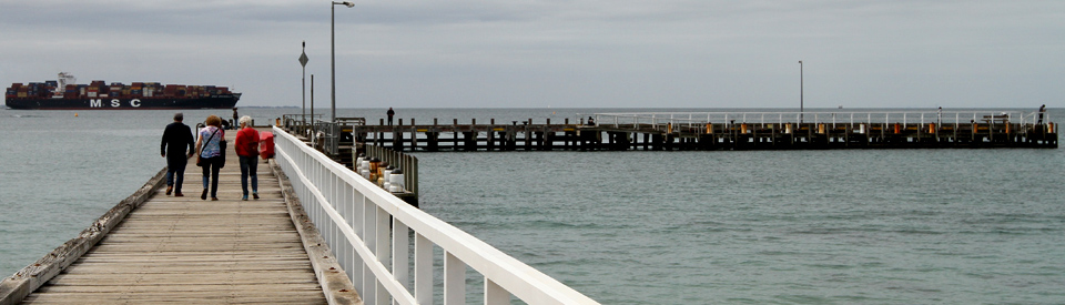
Portsea Beach and Jetty
The Port Phillip Bay side of Portsea is characterised by calm waters and gently sloping crescent-shaped beaches. The long wooden pier is popular with anglers and bathers. There is an excellent walk along the cliffs in both directions from the jetty.
Shelley Beach Walk
This 2.5 km walk starts from the car park on the cliff at Hemston Avenue and proceeds down to Shelley Beach then up the clifftop track to Franklin Road. Return via Franklin Road and the track along Point Nepean Road. It is a very exclusive beach which is characterised by private jetties, boat sheds and a number of colourful bathing boxes.
Millionaire's Walk
Located at the Port Phillip end of Lentell Avenue, Sorrento and extending along the cliffs towards Point King Foreshore Reserve, Millionaire's Walk (it is one kilometre long and takes about an hour) offers views across the bay which are usually reserved for the wealthy who have built their houses on the cliff. The panorama includes views across to the Bellarine Peninsula to the Melbourne CBD and Mount Dandenong. It was also a location where the artists Sir Arthur Streeton, Arthur Boyd and Ray Hodgkinson painted the view and it is part of the Sorrento-Portsea Artists' Trail. The excellent website ( https://www.visitmorningtonpeninsula.org/PlacesToGo/Walks/AllWalks/tabid/399/View/5b59369ba5449ddb7533aeae/Millionaires-Walk/Default.aspx) also notes that: "Located not far from Point King Road is a white rig station and stone monument - this is the place where on the 9th March 1802, Acting Lieutenant John Murray, commander of the 'HMAS Lady Nelson' took possession of Point King, later to be renamed Port Phillip Bay, in the name of His Sacred Majesty George III of Great Britain and Ireland. It was the first time the Union Jack was used in Australia for this purpose."
Sorrento Portsea Artists' Trail
Starting at Sorrento Front Beach (near Bowen Road) with Albert Tucker's Sorrento, 1942 and continuing along the coast to Police Point (Penleigh Boyd's Portsea 1921) and then across the peninsula to Portsea and Sorrento's surf beaches, the Sorrento Portsea Artists Trail was created in 2004 "to bring the artists work to life by positioning images of the paintings as close as possible to the scene viewed by the artist."
The works are:
1. Albert Tucker - Sorrento 1942
2. Roland Clark - Koonya, Continental and Sorrento Hotels 1904
3. Roland Clark - Sorrento Foreshore with Buildings 1904
4. Ray Hodgkinson - View from Munstead Wood c 1947
5. Sir Arthur Streeton - Point King 1920
6. Arthur Boyd - Laycock’s Jetty 1957
7. Sir Arthur Streeton - Sorrento from Point King 1921
8. Sir Arthur Streeton View from Barrett’s Point, Portsea 1921
9. Penleigh Boyd – Portsea 1922
10. Penleigh Boyd – Portsea 1921
11. John Perceval - Quarantine Boundary, Portsea 1957
12. Isaac Whitehead Ocean Beach Sorrento 1871
13. Emanuel Phillips Fox At Sorrento 1915
14. John Perceval Ocean Beach Sorrento 1957
There is a map and detailed information about each of the artworks which can be downloaded at http://www.virtualsorrento.com.au/files/Sorrento-Portsea-Artists-Trail.pdf.
London Bridge
Located to the west of Portsea Surf Beach (reached via London Bridge Road) is the rock formation known as London Bridge. It is a rock arch which has been formed by wave action on a sea stack. It is only accessible at low tide with the beaches on either side being awash at high tide and the cliffs behind the formation being 30-40 metres high. For more information check out https://beachsafe.org.au/beach/vic/mornington-peninsula/portsea/london-bridge-1.
Other Attractions in the Area
Point Nepean National Park
Point Nepean is part of the Mornington Peninsula National Park. It is an ideal place for easy walking (most of the area is flat) and there is an impressive Visitor Centre at the end of Point Nepean Road. The Visitor Centre is part of the old Quarantine Station.
The Park is open from 8.00 am - 5.00 pm and the Visitor Centre is open from 10.00 am - 5.00 pm. There is a useful Visitor Guide which can be downloaded from the "Port Nepean Visitor Guide" button at https://www.parks.vic.gov.au/places-to-see/parks/point-nepean-national-park. The most sensible way to access the park is to drive to the Quarantine Station car park and either walk or take the shuttle bus (it is a hop on, hop off facility) which travels along Defence Road to Gunners Cottage Car Park and Fort Nepean.
Walking at Point Nepean
Quarantine Station to Fort Nepean
There is a 4.5 km walk from the Quarantine Station to Fort Nepean. It can be done through bushland on the Coles Track or on a sealed road via Defence Road. It takes around 90 minutes and offers opportunities to inspect the historic cemetery, the buildings at the Quarantine Station, the ruins of the jetty at Observatory Point, the Harold Holt Memorial, Fort Pearce and Fort Nepean.
There are a number of interpretative walks which branch off the main track to Fort Nepean.
Walter Pisterman Walk
Departing from the Gunners Cottage Car Park, the Walter Pisterman Walk first passes the Point Nepean Cemetery - a strange, isolated cemetery with a number of human silhouettes. The signage at the cemetery explains: "The people buried in this cemetery form part of the fascinating history of Point Nepean. Some of the earliest graves belong to victims of typhus fever from the clipper ship Ticonderoga which arrived from England in 1852 with 350 of its 814 passengers infected. The McRae family were hit hard by this tragedy - a headstone records the deaths of four McRae children and their mother within two months. In 1887 the steamship SS Cheviot was wrecked on the ocean coast at the area now known as Cheviot Beach. Thirty five people died and eight recovered bodies are buried at the cemetery, although only three were identified - Robert Saunders, James Kelly and William Foster."
The walk continues beyond the cemetery to Observatory Point where there are remnants of the Cattle Jetty. The sign at the site notes: "These remains are from the cattle jetty built here in 1879. Late in the 19th century, migrants were arriving in Australia from many different parts of the world. These new settlers brought their own cattle, sheep, horses and other livestock to help establish a new life in Australia. Procedures were needed to check the health of incoming animals as they arrived at the colony as there was a threat to local livestock from diseases such as Rinderpest and Foot and Mouth disease. A holding yard for animals with four stables and two small cottages was located nearby. Animal quarantine facilities were later moved to the Melbourne Zoo, Coode Island and eventually Spotswood."
Cheviot Hill and Harold Holt Memorial
For those on the shuttle bus the stop to access the memorial is Cheviot Hill. The walk is 750 m and it takes around 30 minutes. Cheviot Hill overlooks Cheviot Beach, where former Australian Prime Minister Harold Holt disappeared in December,1967. The offshore waters are now known as the Harold Holt Marine Reserve. The hill is the highest point in the park and has World War II fortifications.
Fort Pearce Heritage Walk
For those on the shuttle bus the stop is titled Fort Pearce. The walk is 800 m and it takes around 45 minutes. Fort Pearce was established in 1911 to use the 6-inch Mark VII guns which had been introduced to coastal defence. The Pearce Barracks were where the army personnel stationed at Point Nepean lived. Eagles Nest was the site of Australia’s largest Disappearing Gun (a disappearing gun is defined by Wikipedia as "a gun mounted on a disappearing carriage, is an obsolete type of artillery which enabled a gun to hide from direct fire and observation.") The lookouts provide panoramic views over Bass Strait and Port Phillip.
Fort Nepean Walk
For those on the shuttle bus the stop is named Fort Nepean. The walk is 1 km and it takes between 1-2 hours. There is a circular track which covers all aspects of the defensive network (the fort, a parade ground, barracks, seven gun emplacements and subterranean passages) that was first established at Point Nepean in 1882. It was designed to guard the entrance to Port Phillip Bay from a possible Russian invasion. Local limestone was used for the construction of underground passages and, by 1900, the fort was allegedly the most heavily armoured outpost in the Southern Hemisphere.
The fort's two cannons allegedly fired the first shot on Britain's side in both World Wars. On August 5, 1914, when Australia received word of Britain's declaration of hostilities, a German freighter happened to be in Port Phillip Bay. A shot was fired from Gun Emplacement 6 across the bow of the freighter and the crew were captured and detained as POWs. A volley from the cannons was fired at the declaration of war in 1939. Unfortunately the target was a Tasmanian freighter which had failed to fly its colours.
Quarantine Station
There are 50 heritage listed buildings in the historical precinct known as the Quarantine Station. It was established in 1852 and is recognised as the second-oldest Quarantine Station in the country. It was built as a result of a ship - the Ticonderoga - entering Port Phillip carrying passengers stricken with typhus. The ship was carrying 795 passengers and 48 crew. Early buildings which are still on the site include five two-storey rendered limestone buildings and a single-storey structure of crudely coursed limestone blocks with a massive limestone chimney. The local Nepean Historical Society has produced a very detailed website on the Quarantine Station which can be accessed at https://nepeanhistoricalsociety.asn.au/history/quarantine-station.
The Coastal Walk
There is a superb 30 km coastal walk along the southern side of Mornington Peninsula from London Bridge in the Point Nepean National Park to Cape Schanck. The route is clearly marked by orange markers and blue signs to indicate departure points for circuit tracks to interesting sites. The total walk takes around eight hours but there are about 30 access points to the coast, mostly from roads which run off Point Nepean Road, consequently it is possible to explore shorter sections. The journey takes in dramatic cliffs, unusual rock formations, tidal rock pools, sand dunes, panoramic views, dense coastal scrub and rugged beaches including Blairgowrie, Rye, St Andrews and Gunnamatta. There is a very detailed guide to the entire walk (which is divided into suitably modest sections) at https://www.visitmorningtonpeninsula.org/PlacesToGo/Walks/AllWalks/tabid/399/View/5b109e2ba142139e1593d118/The-Coastal-Walk/Default.aspx.
History
* Prior to the arrival of Europeans Portsea was home to the Boonwurrung Aboriginal people.
* In January, 1798 George Bass entered Western Port. He named it Western Port as it was, at the time, the most westerly known harbour on the coast.
* Bass returned in October, 1798 with Matthew Flinders. They anchored off Phillip Island.
* Lieutenant James Grant made the first known passage through Bass Strait from the west in 1800.
* Grant returned in 1801 at the instruction of Governor King.
* Nicolas Baudin explored Western Port in April, 1802.
* In 1802 Lieutenant Murray spent over three weeks exploring the area. He named Point Nepean and, at Point King, just to the east of Portsea, he raised the Union Jack. A cairn now marks the spot.
* In 1803, a Lieutenant Collins was placed in charge of a convict settlement at Sullivans Bay (now Sorrento). It was abandoned the following year.
* The first pastoral run at the western end of the peninsula was taken up in 1837.
* Other graziers followed, including James Sandle Ford who, in 1840, took up a parcel of land which he named Portsea after his home town in England. He had been transported to Van Dieman's Land in 1830 for 'machine-breaking' in the agricultural unrest that accompanied the industrial revolution in England.
* As Melbourne grew in the late 1830s there was a growing demand for lime which was used as a mortar in building. Limestone was plentiful on the Mornington Peninsula and a number of kilns were established.
* In the early 1850s a ship entered Port Philip carrying passengers stricken with typhus.
* A quarantine station was established in 1852, just west of the present town of Portsea.
* The first Portsea pier was built in the 1860s.
* A hotel was established in the 1870s.
* A fort with barracks was built at Point Nepean in 1882 to defend the headlands of Port Phillip Bay during a period when there was a fear of a Russian invasion. By the end of the 19th century, the fort was allegedly the most heavily armoured outpost in the Southern Hemisphere.
* The Delgany mansion was built for the Armytage family in 1927.
* The Portsea golf club was opened in the 1920s.
* The Portsea Hotel was opened in 1927.
* In 1967 at Point Nepean Australian prime minister Harold Holt went missing while spear fishing off Cheviot Beach. His body was never recovered. The offshore waters are now known as the Harold Holt Marine Reserve.
* In 1999 a beach bathing box on Fishermans Beach was sold for $185,000.
* Today Portsea is a an up-market holiday spot. In 2011 the median age of residents was 65.
^ TOPVisitor Information
Visitor information for Portsea is available at the Mornington Peninsula Visitor Information Centre, 359B Point Nepean Road, Dromana, tel: 1800 804 009.
^ TOPUseful Websites
There is a useful official website. Check out https://www.visitmorningtonpeninsula.org/PlacesToGo/TownsVillages/Portsea.aspx.
^ TOP