Modern mining town dubbed 'Top Town in Western Australia'.
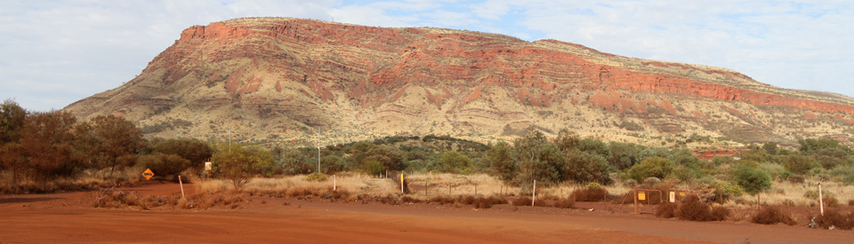
Tom Price is the most attractive purpose-built town in the Inland Pilbara with tree-lined streets, modern facilities, an impressive Visitor Centre and a relaxed country-town atmosphere. Once owned by the Rio Tinto mining company it is now owned and run by the Shire of Ashburton. Located below the impressive Mount Nameless, Tom Price has been described as the 'Top Town in Western Australia' because it is the highest town in Western Australia. It is nestled in the Hamersley Range, a flat-topped mass of Precambrian sediment which was deposited on the sea bed more than 500 million years ago. It is recognised as one of the oldest weathered surfaces on earth. The combination of millions of years of wind, rain and ice (during the Permian Ice Age) has eroded the whole area into a series of spectacular gorges. The end result is some of the most beautiful and dramatic landscapes in Australia. The gorges are notable for their distinctive horizontal bedding where layers of red, black and brown iron form bands of colour with conglomerates and sandstone. The area has been denuded by the harshness of the summers with ghost gums, red river gums and wildflowers (including the Sturt Desert Pea) giving the landscape a special beauty.
Location
Tom Price is located 1469 km north of Perth via Newman or 1546 km via Geraldton and Carnarvon. Dubbed 'Top Town in Western Australia' because it is 747 m above sea level, and thus the highest town in the state.
^ TOPOrigin of Name
Tom Price (both the town, the mine and the mountain) was named after Thomas Moore Price, the vice-president of the giant United States steel company Kaiser Steel. Price was one of the main initiators and supporters of the opening up of the Pilbara region to iron ore mining.
^ TOPThings to See and Do
Rio Tinto Iron Ore Mine
The Mount Tom Price iron ore mine, which is only observable if you take a tour, is fully owned by the international mining company Rio Tinto and is part of Rio Tinto's Hamersley iron ore operations. The mine began mining operations in 1966. The actual Mount Tom Price open cut mine is located in the mineral rich Hamersley Range. The range is so rich that it is estimated to contain up to 80 percent of all known reserves of iron ore in Australia.
Mount Tom Price was the first mining operation in the Pilbara Region by Rio Tinto. Today the operation has expanded so that there are now a total of 14 mines, three shipping terminals (Dampier, Port Hedland and Cape Lambert) and the largest private railway network in Australia.
Iron ore mining began at Mount Tom Price in 1965 and the ore was railed 260 kilometres to the port at Dampier where most of it was loaded on ships bound for Japan.
The Mount Tom Price iron ore deposit is around 1.6 kilometres wide at its widest point and is 7.5 kilometres long. It extends to a depth of 250 metres. The Mining Link website (http://mininglink.com.au/site/mt-tom-price) offers a detailed history of mining in the area and notes that: "Iron ore mined at the Mount Tom Price Mine is subjected to the world's first commercial direct smelting procedure through a process known as high-intensity smelting, or HIsmelt. This process produces iron straight from the ore. This is achieved by injecting non-coking coal and fine iron ore directly into a molten iron bath that is constructed within a SRV (smelt reduction vessel). This procedure produces a high quality molten pig iron. HIsmelt has the potential to eventually replace the blast furnace as it is far cheaper and produces ideal units for steelmakers."
Rio Tinto Iron Ore Mine Site Tours
There are 90 minute tours of the Rio Tinto Iron Ore Mine Site run by Lestok Tours (minimum numbers apply). The tours depart daily and can be booked at the Tom Price Visitor Centre, tel: (08) 9188 1112. Each tour includes a visit to the Haul Truck workshop, a visit to the lookout over the main pit area, the crushing and screening plants, the world's largest mining equipment and the train load-out area. The tour has a detailed commentary. The giant 200 tonne capacity haul trucks carry ore to the primary crushers where low grade ore is concentrated for export. It is necessary to wear covered footwear. For specific details check out http://www.lestoktours.com.au/pilbaramine.html or tel: (08) 9188 1112.
Mount Nameless (Jarndunmunha)
The road which leads south from the town to the mine (ie Mine Road) passes the turnoff to Mount Nameless, which, at 1128 metres above sea-level, is the highest mountain in Western Australia that has a summit accessible by vehicle. It is about 4 km from town via Mine Road. Access is via both walking trail (it is about 2.5 hours return) and 4WD vehicle. The panoramic view takes in the town site and mine site. The walking trail starts near Tom Price Tourist Park. There is a useful, detailed description for 4WD drivers at http://www.4wdingaustralia.com/4x4/wa-locations/a-drive-up-mount-nameless. The drive to the top is difficult and complex. Don't attempt it unless you are a confident 4WD driver.
Kings Lake
Located 5 km west of the town on Nameless Valley Road is Kings Lake, an artificial lake (no swimming allowed) with pleasant grassed areas which are ideal for picnics and barbecues. The lake is covered in green plants which makes it unsuitable for swimming but quite striking when first seen.
Other Attractions in the Area
Mt Sheila Lookout and Hamersley Gorge
Located 41 km to the north of Tom Price is Mt Sheila Lookout which offers panoramic views of the area, although access is 4WD only. The usual route is along Tom Price Railway Road which requires that you obtain a permit from the Visitor Office. The road passes Hamersley Station, the former home of iron ore magnate, Lang Hancock. The spectacular Hamersley Gorge is some 45 km east of Mt Sheila on the road to Wittenoom. The gorge is a pleasant place for a picnic and a swim. Tel: Tom Price Visitor Centre on (08) 9188 1112 for additional details or check out https://parks.dpaw.wa.gov.au/site/hamersley-gorge.
Karijini National Park
Located 45 km north east of Tom Price is Karijini National Park, in the Hamersley Ranges, which is home to the Banyjima, Yinhawangka and Kurrama Aboriginal people. The Park, the second largest in Western Australia, covers 627,442 ha and incorporates two billion year old gorges where rain has cut 45 metre ravines forming dramatic outcrops and tiered rock formations. There are a number of worthwhile experiences in the National Park. The following are regarded as capturing the essence of the park. There is a very detailed brochure which can be downloaded at https://parks.dpaw.wa.gov.au/sites/default/files/downloads/parks/20130200%20Karijini%20National%20Park%20broch6.pdf and extensive information can be obtained at the Visitor Centres in Newman, Tom Price and Karratha.
The road from Tom Price to both entrances to the park is now sealed. It is a modern, good quality road and you can happily zip along at 110km/hr.
The Western Entrance to the Park
The Western Entrance to the park is located 45 km from Tom Price. The road, Karijini Drive, is sealed. Before drivers turn off to the Western Entrance there is Mount Bruce looming over the flat landscape.
Climbing Mount Bruce (Punurrunha)
At the western entrance to the Park there is a road which leads to Mt Bruce (at 1235 metres the second-highest peak in the state). It is possible to climb Mount Bruce but the track is 9.2 km up hill (it will take around 3 hours return) with the reward being that (a) you have climbed the second highest peak in Western Australia and you will experience a superb, panoramic view over the spinifex-covered plains and the rugged Hamersley Range (b) there is a 500 metre (30 minutes return) Marandoo View walk which provides an excellent view over the Marandoo Mine site.
There is a route into the park, past an Entry Station, which lies north along Banjima Drive. In 2017 it was partly sealed and a section was a difficult 4WD road. Continue 28 km north from the entry gate. If you continue straight ahead you will reach Karijini Eco Retreat which provides access to the Joffre lookout over the Joffre Falls.
Karijini Eco Retreat and Lookouts
Karijini Eco Lodge is located within walking distance of Joffre Gorge. Owned by the local Gumala Aboriginal Corporation, it has accommodation options ranging from camping sites to deluxe eco tents. There is also a very good open air restaurant. It is an idyllic location. The eco tents mimic those in African safari locations - simple and with no modern conveniences. You shower under the stars and are protected by zippers from insects eager to get to the lights.
Weano Day Use and Hancock Gorge
Located 13 km north of the Eco Retreat are the lookouts over the Hancock and Weano Gorges. The Oxer and Junction Pool lookouts are 800 metres from the car park and provide impressive views over the Hancock Gorge. The Oxer Lookout has views over the junction of four gorges: Weano, Red, Hancock and Joffre. Many consider the view from Oxer Lookout to be one of the most spectacular sights in Western Australia. The vantage point offers a unique perspective of the area's enormity and grandeur.
Joffre and Knox Gorges
From the Eco Lodge it is possible to inspect the Joffre and Knox Gorges by driving 3 km east on the Banjima Drive North and turning north. There are two short walks to lookouts - it is 100 metres from the car park to Joffre Lookout and the steps which go down to a lookout where the Joffre Falls, a spectacular curved waterfall which forms a natural amphitheatre, can be viewed. The Knox Lookout is 300 metres from the car park and offers a panoramic view which is particularly impressive in the early morning or late afternoon.
The Eastern Entrance to the Park
The Park's Visitor Centre
From the Western Entrance to the Park, it is possible to drive along the sealed Karijini Drive to the eastern entrance station on Bunjima Drive. 10 km north of the junction with Karijini Drive is the Visitor Centre. The centre is designed to represent a goanna moving through the country. The centre is an ideal introduction to the park. It has interactive displays highlighting the geology, plants, animals and Aboriginal culture of the Park. The Visitor Centre can be contacted on (08) 9189 8121.
Dales Day Use Area
Drive 12 km east from the Visitor Centre (10 km from the turnoff to the Visitor Centre) and you will reach Dales Day Use and Camping Area. There are two highlights: Fortescue Falls and the Circular Pool. There is a swimming hole at Fortescue Falls. From the car park there is a one hour walk down a modern, iron staircase and along paths to the falls. There is also the refreshing, spring-fed Fern Pool or enthusiastic visitors can take the two-hour return walk to the mysterious and beautiful Circular Pool, at the other end of the gorge. This is the essential experience of the park. The walk down to the pool is easy (for every step down you will have to take a step back) and the large pool below the falls is a delightful way to wash off the red dust and cool down on a hot day.
Kalamina Falls
Return 12 km to the Visitor Centre and continue westward on the Bunjima Drive for 17 km (this road can be variable - in August, 2017 it was so badly corrugated that we were advised that it would be quicker to return to Karijini Drive and drive along to the western entrance to the park - that advice was freely available at both the Newman and Tom Price Visitor Centres) and you will reach a northern turn to the Kalamina Falls. The gorge is another 8 km and it recognised as one of the prettiest gorges in the park with an easy trail and a pleasant picnic area. There is a 3 km (3 hours return) walk into the gorge.
Fauna and Flora in the Park
Karijini’s rugged red gorges boast abundant native vegetation such as spinifex, mulga, ghost gums and fig trees. Between June and September, colourful wildflowers such as wattles, lemongrass and northern bluebells bloom across the landscape. You may also spot rock wallabies, dingoes and the abundant birdlife.
Tours of the Park
Lestok Tours run full day tours to the Park which can be booked at the Tom Price Visitor Centre, tel: (08) 9188 1112. Check out http://www.lestoktours.com.au/karijinipark.html for details. The tour includes a visit to Oxers Lookout and Circular Pool Lookout, a walk through Weano Gorge and a visit to Handrail Pool, exploration of Joffre Falls and Knox Lookout and a swim at Fern Pool. It departs from Tom Price between 7.15 am and 7.30 am.
History
* Prior to the arrival of Europeans the area had been home to the Banjima people for over 30,000 years.
* As early as 1952 Lang Hancock, the iron magnate, carried out aerial surveys over the Tom Price area and detected large iron ore deposits. His discoveries were of little value at the time because the Australian Government had an embargo on all iron and steel exports. This was a result of World War II.
* After the lifting of the embargo in 1961 the area began to open up.
* The whole operation came into existence after two geologists, Bill Burns and Ian Whitcher, landed on Mount Tom Price in 1962 and discovered that it was almost pure iron ore.
* In the 1960s Hamersley Iron Pty Ltd (now a wholly owned subsidiary of Rio Tinto) built the railway from the town to the port of Dampier, and opened the mine.
* The town was constructed as a service centre and residential area for the miners.
* Today Tom Price is a modern town catering for miners and their predominantly young families. The town is currently owned and administered by the Ashburton Shire Council.
^ TOPVisitor Information
Tom Price Visitor Centre, Central Road, (08) 9188 5488. It is open between May and November from 8.30 am - 5.00 pm Monday to Friday and 8.30 am - 12.30 pm on Saturdays and Sundays.
^ TOPUseful Websites
There is an official website. Check out http://www.tomprice.org.au.
^ TOP
The first shipments of ore in 1966 were to Japan not China. The economics of the mine were based on an initial contract to supply three million tons per year to Japan. Due to increased demand there was a rapid increase in mining capacity and by 1971 the capacity had been increased to 22.5 million tons per year.
How far is the Albert Toglioni Rest Area from Tom Price and is it bitumen from the inland road into Tom Price?
I found NO mention of the town and inhabitants. Is it safe during cyclones? My niece is teaching there and I am concerned for her safety.
My name is Harry Westcott, who along with my wife Doreen &5 children, was the first Christian Minister of any denomination to reside in Tom Price. I was a Methodist minister, sent to represent the Lord Jesus Christ for the soon to be Uniting protestant denominations.
I have a wonderful story to share of Tom Price, if you are interested? 1969-1972
In His Grip
Bishop Harry Westcott
Hi Harry Westcott
I too a Methodist in Gippsland Vic and the dating back to the first free settlers 1850’s- the church closed due to lack of faith in the 60/70s – so sad as their faith was so equal to all human and other creatures